Mount Everts Viewpoint
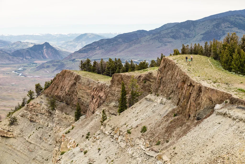 Photo: NPS / public domain
- Jul–Sep
- best months
Is Mount Everts Viewpoint open right now?
Closure in the area
There's a closure order in Yellowstone National Park. It doesn't name Mount Everts Viewpoint, so check the source for the area it covers (2 listed).
Most Park Roads Closed to All Vehicles
Park closure covering Yellowstone National Park · NPS · Yellowstone National Park
Biscuit Basin Closed Due to Hydrothermal Explosion
Park closure covering Yellowstone National Park · NPS · Yellowstone National Park
As of · Source: NPS · Yellowstone National Park. Agencies don't list every closure — check before you go.
Mount Everts is a 7,846-foot peak in Yellowstone National Park near Mammoth Hot Springs. The peak was named for Truman C. Everts, a member of the Washburn-Langford-Doane surveying expedition of 1870. Just days into the journey, Everts became separated from the group, and his horse, carrying all his supplies, disappeared into the wilderness. Alone and unprepared, he faced a harrowing fight for survival. Everts had no food, no shelter, and no tools to start a fire. For 37 days, he wandered through the vast, uncharted Yellowstone landscape, battling hunger, cold, and exhaustion. He lived on little more than thistle roots, which he boiled when geothermal heat allowed or ate raw. His hands and feet were burned from the scalding ground as he tried to warm himself. Nights brought freezing temperatures, and he huddled under scant cover, shivering against the cold. At one point, he hallucinated that a mountain lion was following him, a reflection of his deteriorating mental and physical state. Despite the odds, Everts survived. Near starvation and weighing only 50 pounds, he was found by hunters and brought back to civilization. His story, published in vivid detail, captivated the nation, showcasing both the dangers and the beauty of the Yellowstone region. It became one of the many tales that spurred the push to preserve this wilderness, culminating in the creation of Yellowstone National Park in 1872. Rising steeply from the landscape, Mount Everts is a striking feature of Yellowstone’s northern region, and its geology tells an even older story than Everts’ misadventure. Mount Everts is made up of two distinct layers of rock, separated by a geologic feature known as an unconformity. Near the base of the mountain are gray strata of Cretaceous sedimentary rock, over 65 million years old, formed when this area was the margin of a shallow inland sea. Imagine a landscape similar to today’s Mississippi River delta—mud and sand settling at the edge of the sea, compacted over millions of years into sandstone and shale. These layers were later uplifted by tectonic forces, exposing them to erosion. The light red rock at the top of Mount Everts is Huckleberry Ridge Tuff, formed around 2.1 million years ago during Yellowstone’s first caldera-forming volcanic eruption. This eruption was catastrophic, covering much of the surrounding region with superheated ash flows. The interface between these two rock layers tells a fascinating story. The eruption’s initial ashfall formed a thin white layer, representing the opening phase of the event. Above it is a thin black layer of ash that “quenched,” or cooled instantly, against the older ground surface. The reddish color in the sedimentary rock just below the tuff is a result of the intense heat, which “baked” the older layers as the ash settled on top. This unconformity—where rocks of vastly different ages are in direct contact—represents millions of years of missing geologic history. Layers that might have once existed between the sedimentary rock and the tuff were eroded away, leaving this dramatic boundary for modern geologists to study.
- Osprey Falls TrailHiking1.1 mi
- YCC TrailHiking1.2 mi
 Mammoth Terraces TrailHikingPhoto: Greg Willis from Denver, CO, usa, CC BY-SA 2.0 (via Wikimedia Commons)1.5 mi
- Cavalry Barracks (1891)Hiking1.5 mi
 The HoodoosRock climbingPhoto: Ken Lund, CC BY-SA 2.0 (via Flickr)2.1 mi
 Gardner RiverCanoeingPhoto: Jo Suderman, Public domain (via Wikimedia Commons)4.1 mi
- Gardiner DistrictLake fishing5.6 mi
- Eagle CreekCamping5.9 mi
Source: Roamze catalog (indexable pages within 10 miles, PostGIS distance)
- Mammoth Terraces TrailHiking · ~3 min drivePhoto: Greg Willis from Denver, CO, usa, CC BY-SA 2.0 (via Wikimedia Commons)
- Minerva TerraceHiking · ~3 min drive
- Bunsen Peak OverlookHiking · ~3 min drive
 Lava Creek TrailHiking · ~4 min drivePhoto: R. Sieben, CC BY 3.0 (via Wikimedia Commons)
 Sportsman Lake TrailHiking · ~6 min drivePhoto: cchadek, CC BY 3.0 (via Wikimedia Commons)
- Lava Creek Trailhead (1N3)Hiking · ~3 min drive
- Liberty CapHiking · ~3 min drive
 Bunsen Peak TrailHiking · ~5 min drivePhoto: cchadek, CC BY 3.0 (via Wikimedia Commons)
 Blacktail Deer Creek TrailHiking · ~7 min drivePhoto: cchadek, CC BY 3.0 (via Wikimedia Commons)
 Yellowstone River TrailHiking · ~9 min drivePhoto: Forest Service - Northern Region, Public Domain Mark (via Flickr)
Also worth it near here
 Mammoth CampgroundCamping · ~3 min drivePhoto: Yellowstone National Park from Yellowstone NP, USA, Public domain (via Wikimedia Commons)
- The HoodoosRock climbing · ~4 min drivePhoto: Ken Lund, CC BY-SA 2.0 (via Flickr)
 Bunsen PeakSummit · ~4 min drivePhoto: Mike, Public domain (via Wikimedia Commons)
 Rustic FallsWaterfall · ~5 min drivePhoto: James St. John, CC BY 2.0 (via Wikimedia Commons)
Best time to visit Mount Everts Viewpoint
Best months: July–September. Best months have typical highs of 55–85 °F, lows of 30 °F or warmer (32 °F where the station doesn't record snow), at most one snowy day and no more than 12 wet days.
Jan
31° / 12°
11 wet · 9 snow
Feb
34° / 12°
11 wet · 9 snow
Mar
42° / 19°
11 wet · 7 snow
Apr
50° / 26°
11 wet · 5 snow
May
60° / 35°
13 wet · 2 snow
Jun
69° / 42°
13 wet
Jul
81° / 48°
10 wet
Aug
80° / 47°
9 wet
Sep
69° / 39°
9 wet · 1 snow
Oct
54° / 29°
9 wet · 3 snow
Nov
39° / 19°
10 wet · 7 snow
Dec
30° / 12°
12 wet · 10 snow
Typical high / low (°F) and days with rain or snow, 1991–2020. Measured at Yellowstone Park Mammoth, WY, 1.5 mi away at 6,195 ft. Source: NOAA NCEI U.S. Climate Normals 1991–2020.
