Montana · Summit
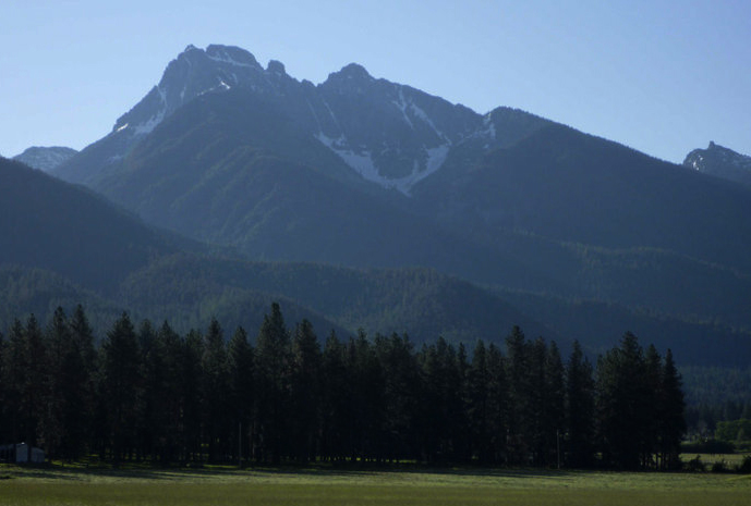
Gray Wolf Peak
 Photo: Thad Lowary, US Forest Service, Public domain (via Wikimedia Commons)
- 8,998 ft
- summit
Loading this week's forecast
Gray Wolf Peak is a summit in Lake County, Montana, at about 8,998 feet.
Conditions and forecast
Daily highs and lows, wind and the chance of precipitation at the summit for the next 7 days, from the Open-Meteo model.
- Summit elevation
- 8,998 ft
Elevation from USGS 3D Elevation Program terrain data (about 10 m resolution).
We don't know of a mapped trail or route to the summit of Gray Wolf Peak. Plan the approach with local maps, a guidebook or a local guide, and check conditions before you go.
Questions about Gray Wolf Peak
How tall is Gray Wolf Peak?
8,998 ft (2,743 m).
Is there a trail to the top of Gray Wolf Peak?
We don't know of a mapped trail or route to the summit. Plan the approach with local maps, a guidebook or a local guide.
- Riddell LakesHiking3.3 mi
- LindberghHiking5.2 mi
- Lucifer Lake TrailHiking5.5 mi
- Crystal LakeHiking5.6 mi
- Turquoise LakeHiking6.6 mi
- Glacier Lake FeederHiking6.7 mi
- JockoHiking6.9 mi
- Mission CreekCanoeing9.6 mi
Source: Roamze catalog (indexable pages within 10 miles, PostGIS distance)
 Mount CalowahcanSummit · ~21 min drivePhoto: Run shane run Shane Thomas McMillan, CC BY-SA 3.0 (via Wikimedia Commons)
- Hemlock PointSummit · ~20 min drive
- Triangle PeakSummit · ~23 min drive
- Boles PointSummit · ~26 min drive
- Red Sleep MountainSummit · ~27 min drive
- Richmond PeakSummit · ~30 min drive
- Shaw MountainSummit · ~38 min drive
- Tango PointSummit · ~39 min drive
- Sheep MountainSummit · ~41 min drive
- Lena PeakSummit · ~41 min drive
