North Peaks Trail
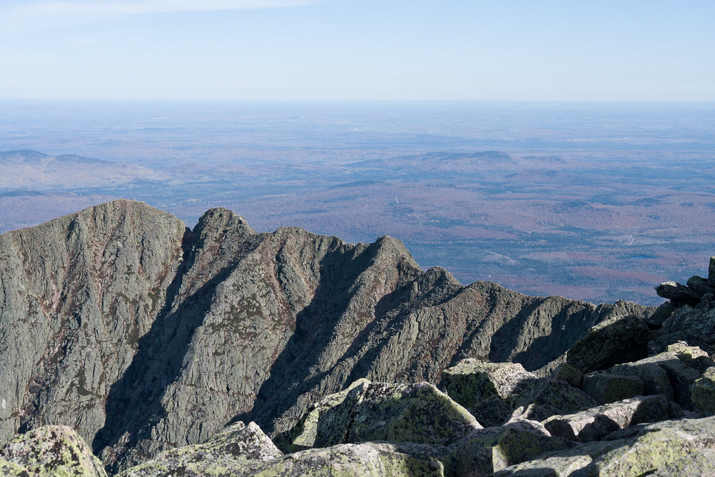 Photo: Pat Spinney, CC BY 2.0 (via Flickr)
- 5.2 mi
- one way
- 3,247 ft
- climb
- 4,743 ft
- high point
- Point to point
- route
North Peaks Trail is a hard hike in Baxter State Park in Maine, managed by State Park and Recreation. It is a point-to-point route of about 5 miles, with a total elevation gain of 3,247 feet. The trail starts at about 4,618 feet and climbs to a high point of 4,743 feet, then descends to a low of 1,489 feet, with the steepest stretch at about 3.3 miles in. The route is not for the faint of heart. It is a long, steep climb, and the trail is not open to bikes or horses. Plan on about 3.5 hours for the trip. Several other trails sit close by. Northwest Basin Trail is about 0.1 mile away, and Hamlin Peak Cut-Off and Hamlin Ridge Trail are each about 0.2 mile away. Climbers can find North Basin about 1.2 miles off.
- Northwest Basin TrailHiking0.1 mi
- Hamlin Peak Cut-OffHiking0.2 mi
- Hamlin Ridge TrailHiking0.2 mi
 North Basin TrailHikingPhoto: davidwilson1949, CC BY 2.0 (via Flickr)1.1 mi
 North BasinRock climbingPhoto: Famartin, CC BY-SA 4.0 (via Wikimedia Commons)1.2 mi
- Chimney Pond ("South") Basin - Summer Rock RoutesRock climbing1.2 mi
- KatahdinRock climbing4.2 mi
- West Branch Penobscot RiverRiver fishing6.4 mi
Source: Roamze catalog (indexable pages within 10 miles, PostGIS distance)
- North Basin TrailHiking · ~2 min drivePhoto: davidwilson1949, CC BY 2.0 (via Flickr)
- North Basin Cut-OffHiking · ~2 min drivePhoto: Pat Spinney, CC BY 2.0 (via Flickr)
 Abol Slide TrailHiking · ~3 min drivePhoto: barry.pousman, CC BY 2.0 (via Flickr)
- Chimney Pond TrailHiking · ~2 min drivePhoto: Pat Spinney, CC BY 2.0 (via Flickr)
- Baxter Peak Cutoff TrailHiking · ~3 min drivePhoto: barry.pousman, CC BY 2.0 (via Flickr)
 Hunt TrailHiking · ~7 min drivePhoto: barry.pousman, CC BY 2.0 (via Flickr)
 Dudley TrailHiking · ~2 min drivePhoto: davidwilson1949, CC BY 2.0 (via Flickr)
- Appalachian TrailHiking · ~9 min drivePhoto: barry.pousman, CC BY 2.0 (via Flickr)
- Helon Taylor TrailHiking · ~6 min drive
- Owl TrailHiking · ~6 min drivePhoto: barry.pousman, CC BY 2.0 (via Flickr)
Route details
- Distance
- 5.2 mi
- Climbing
- About 3,247 ft
- Summit
- 4,743 ft
- Difficulty
- Hard
- Time
- About 2 hours
Questions about this route
How long is the North Peaks Trail on Howe Peaks?
About 5.2 mi.
How much elevation gain is on the North Peaks Trail?
About 3,247 ft of climbing round trip.
How hard is the North Peaks Trail?
It is rated hard.
How long does the North Peaks Trail take?
About 2 hours round trip.
Conditions and forecast on Howe Peaks
Daily highs and lows, wind and the chance of precipitation at the summit and route start for the next 7 days, from the Open-Meteo model.
Map and trail data © OpenStreetMap contributors
