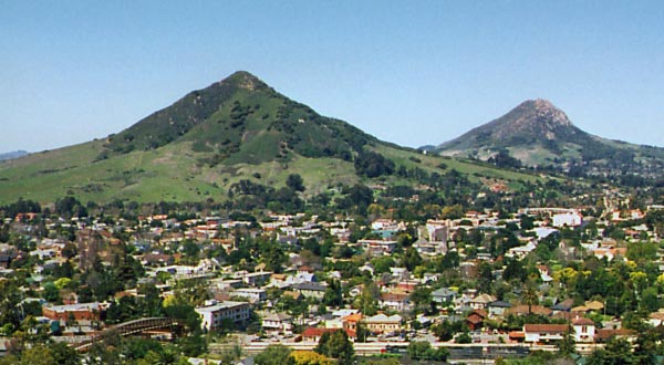
Cerro San Luis Obispo
Cerro San Luis Obispo is a California climbing area with 1 traditional route.
- 1 route
- 5.7
- Trad
Best time to visit Cerro San Luis Obispo
Best months: Year-round. Best months have typical highs of 55–85 °F, lows of 30 °F or warmer (32 °F where the station doesn't record snow), at most one snowy day and no more than 12 wet days.
Jan
65° / 44°
9 wet
Feb
65° / 44°
9 wet
Mar
67° / 46°
8 wet
Apr
69° / 47°
4 wet
May
72° / 49°
2 wet
Jun
76° / 52°
1 wet
Jul
78° / 54°
0 wet
Aug
80° / 55°
0 wet
Sep
80° / 54°
1 wet
Oct
78° / 52°
3 wet
Nov
71° / 47°
5 wet
Dec
64° / 44°
8 wet
Typical high / low (°F) and days with rain or snow, 1991–2020. Measured at San Luis Obispo Poly, CA, 1.8 mi away at 308 ft. The station sits about 600 ft lower than this place, so expect it a little cooler here. Source: NOAA NCEI U.S. Climate Normals 1991–2020.
Cerro San Luis Obispo is a climbing area in California, about a mile from the town of San Luis Obispo. It sits close to several hiking trails and other climbing spots, making it an easy addition to a day spent exploring the area. The most comfortable months for a visit are typically late spring and early fall. Typical averages from a nearby weather station in San Luis Obispo show May highs around 72°F and September highs around 80°F, with almost no wet days in July and August. That station sits a few hundred feet lower than the climbing area, so temperatures up high run a little cooler. The area has one route, Leapin' Lizards, a trad climb rated 5.7 on the YDS scale. It pairs well with the Perimeter Trail, which starts just 0.2 miles away, and the M Trail and the Cerro San Luis Connector Trail, both within about a third of a mile.
Routes (1)
Trail Boulder(1)
Keep exploring — more climbs worth the drive
 Photo: hakkun, CC BY-SA 3.0 (via Wikimedia Commons)
Chlorissa
~3 min drive
Chlorissa is a California climbing area with 10 routes on 7 difficulty grades.
Photo: hakkun, CC BY-SA 3.0 (via Wikimedia Commons)P-Wall
~3 min drive
P-Wall in California has 39 climbing routes across 16 difficulty grades.
Photo: hakkun, CC BY-SA 3.0 (via Wikimedia Commons)Hidden Gully
~3 min drive
Hidden Gully in California has 6 routes across 6 grades, offering mixed, sport, and trad climbing.
 Photo: Sergei Gussev, CC BY 3.0 (via Wikimedia Commons)
Grime Dog Wall
~15 min drive
Grime Dog Wall in California has 6 routes with 5 difficulty grades, offering bouldering and sport climbing.
 Photo: Mike Baird from Morro Bay, USA, CC BY 2.0 (via Wikimedia Commons)
Cabrillo Peak
~16 min drive
Cabrillo Peak in California has 12 climbing routes with 11 difficulty grades.
Photo: Mike Baird from Morro Bay, USA, CC BY 2.0 (via Wikimedia Commons)Rock Land
~16 min drive
Rock Land in California has 13 routes across 9 grades with mixed, sport, and trad climbing.
 Photo: Ken Lund, CC BY-SA 2.0 (via Flickr)
Morro Bay Harbor
~21 min drive
Morro Bay Harbor, California climbing area with 2 routes.
 Photo: vonguard, CC BY-SA 2.0 (via Flickr)
Breakwater Boulder
~21 min drive
Breakwater Boulder in California has 6 bouldering routes across 5 grades.
Toprope Boulder
~1 min drive
Toprope Boulder in California has 4 routes across 3 grades, offering bouldering and sport climbing.
Boulder In The Woods
~2 min drive
Boulder In The Woods is a 12-route bouldering area in California with 8 difficulty grades.