Quercus Trail
- 0.4 mi
- round trip
- 98 ft
- climb
- Singletrack
- surface
- Out and back
- route
- Jan–Dec
- best months
Clear at last check
Weather is good · OpenWeather · checked 16 h ago
Quercus Trail is a short mountain biking route in California, about 1.4 miles from the town of Thyle. It is an out-and-back ride of roughly 0.74 miles, with a low point of 919 feet and a high of 1,036 feet, so the climb is only about 98 feet one way. Late spring and early fall are the most comfortable times to ride. Typical averages from a nearby weather station show May highs around 72°F and October highs around 78°F, with almost no wet days in July and August. That station sits well below the trail, so temperatures on the route run cooler. The Roller Coaster/Tunnel 10 Truck Trail starts just 0.1 mile away, and the Panorama Trail is about 0.4 mile off. Climbers can head to Artificial/Man-made Walls, about 0.7 mile away, and anglers will find Santa Margarita Lake Recreation Area roughly 8 miles away.
 Roller Coaster/Tunnel 10 Truck TrailHikingPhoto: SDASM Archives, Public domain (via Wikimedia Commons)0.1 mi
- Panorama TrailHikingPhoto: SDASM Archives, Public domain (via Wikimedia Commons)0.4 mi
 Roller Coaster / Truck TrailHikingPhoto: MattCC716, CC BY-SA 2.0 (via Flickr)0.4 mi
- Artificial/Man-made WallsRock climbing0.7 mi
- Toprope BoulderRock climbing3.3 mi
- SummitRock climbing3.3 mi
- Santa Margarita Lake Recreation AreaLake fishing8.1 mi
- Cerro AltoCamping9.4 mi
Source: Roamze catalog (indexable pages within 10 miles, PostGIS distance)
- Panorama TrailMountain biking · Next door
- Morning GloryMountain biking · ~5 min drive
- Pick And ShovelMountain biking · ~7 min drive
- Rocky TrailMountain biking · ~13 min drive
- Red DogMountain biking · ~2 min drive
- One Shot: Brandon Semenuk's unReal SegmentMountain biking · ~43 min drive
- Rocky TrailMountain biking · ~13 min drive
- Lower Red DogMountain biking · ~2 min drive
- Rocky TrailMountain biking · ~14 min drive
- Shooters TrailMountain biking · ~3 min drive
Also worth it near here
- Roller Coaster/Tunnel 10 Truck TrailHiking · Next doorPhoto: SDASM Archives, Public domain (via Wikimedia Commons)
- Route 1 - San Luis Obispo North Coast BywayScenic drive · ~5 min drive
 ChlorissaRock climbing · ~6 min drivePhoto: hakkun, CC BY-SA 3.0 (via Wikimedia Commons)
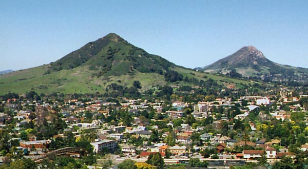 Cerro San Luis ObispoSummit · ~6 min drivePhoto: Ken Broomfield, CC BY-SA 3.0 (via Wikimedia Commons)
Best time to visit Quercus Trail
Best months: Year-round. Best months have typical highs of 55–85 °F, lows of 30 °F or warmer (32 °F where the station doesn't record snow), at most one snowy day and no more than 12 wet days.
Jan
65° / 44°
9 wet
Feb
65° / 44°
9 wet
Mar
67° / 46°
8 wet
Apr
69° / 47°
4 wet
May
72° / 49°
2 wet
Jun
76° / 52°
1 wet
Jul
78° / 54°
0 wet
Aug
80° / 55°
0 wet
Sep
80° / 54°
1 wet
Oct
78° / 52°
3 wet
Nov
71° / 47°
5 wet
Dec
64° / 44°
8 wet
Typical high / low (°F) and days with rain or snow, 1991–2020. Measured at San Luis Obispo Poly, CA, 1.9 mi away at 308 ft. The station sits about 700 ft lower than this place, so expect it a little cooler here. Source: NOAA NCEI U.S. Climate Normals 1991–2020.
Map and trail data © OpenStreetMap contributors
