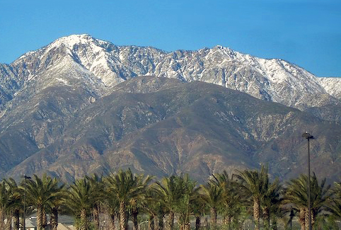
Timber Mountain
 Photo: Mitch Barrie (simonov), CC BY-SA 2.0 (via Wikimedia Commons)
At a glance
Timber Mountain is a summit of about 8,300 feet in San Bernardino County, California, inside the Cucamonga Wilderness. The peak lies within the Front Country Ranger District of San Bernardino National Forest, which the Forest Service manages, and the nearest town is Lytle Creek, about 5 miles away. Several trails start close to the summit. Ontario Peak Trail and Bighorn Peak Trail are each about 0.4 miles away, and the Cucamonga Pk-Icehouse Saddle route is a similar distance. Icehouse Canyon, a climbing area, sits about 1.5 miles off. Manker Flat campground is about 2.5 miles away, and Lytle Creek - Cajon Pass Recreation Area offers river fishing about 6.5 miles away.
- summit
- 8,300 ft
- managed by
- Forest Service
Where it is: Cucamonga Wilderness · Front Country Ranger District
Near: Rancho Cucamonga
Been here? Tell people how it was.
We don't know of a mapped trail or route to the summit of Timber Mountain. Plan the approach with local maps, a guidebook or a local guide, and check conditions before you go.
- Bighorn Peak8,441 ft · California1 route0.8 mi away
- Telegraph Peak8,980 ft · California2 routes1.2 mi away
- Thunder Mountain8,565 ft · California1 route1.6 mi away
 Cucamonga Peak8,859 ft · California1 route1.6 mi awayPhoto: Cliff Hutson; later cropping and color editing by Daniel Case., CC BY 2.0 (via Wikimedia Commons)
- Ontario Peak8,694 ft · California1 route2.1 mi away
- Mount San Antonio10,067 ft · California4 routes4.3 mi away
- Ontario Peak TrailHiking0.4 mi
 BIGHORN PEAK TRAILHikingPhoto: Mitch from Costa Mesa, CA, USA, CC BY-SA 2.0 (via Wikimedia Commons)0.4 mi
- Cucamonga Pk- Icehouse SaddleHikingPhoto: Mitch from Costa Mesa, CA, USA, CC BY-SA 2.0 (via Wikimedia Commons)0.4 mi
- Icehouse CanyonRock climbing1.5 mi
- Mount Baldy RoadRock climbing2.4 mi
- Manker FlatCamping2.5 mi
- Lytle Creek - Cajon Pass Recreation AreaRiver fishing6.5 mi
- LupineCamping7.2 mi
- Cucamonga PeakSummitPhoto: Cliff Hutson; later cropping and color editing by Daniel Case., CC BY 2.0 (via Wikimedia Commons)~3 min drive
 Iron MountainSummitPhoto: Self, CC BY 3.0 (via Wikimedia Commons)~13 min drive
 Mount Baden-PowellSummitPhoto: The original uploader was Jakerome at English Wikipedia./ Simonov, CC BY-SA 2.0 (via Wikimedia Commons)~21 min drive
 Mount IslipSummitPhoto: Eeekster, CC BY 3.0 (via Wikimedia Commons)~27 min drive
 Mount JurupaSummitPhoto: Scottthezombie, CC BY-SA 4.0 (via Wikimedia Commons)~29 min drive
 Mount RubidouxSummitPhoto: No machine-readable author provided. Takwish assumed (based on copyright claims)., CC BY-SA 2.5 (via Wikimedia Commons)~37 min drive
 Mount BurnhamSummitPhoto: Ctatkinson, Public domain (via Wikimedia Commons)~23 min drive
 Throop PeakSummitPhoto: Eeekster, CC BY 3.0 (via Wikimedia Commons)~24 min drive
 Slover MountainSummitPhoto: Unknown authorUnknown author, Public domain (via Wikimedia Commons)~33 min drive
- Bighorn PeakSummit~1 min drive
Conditions and forecast
Caution todayAgency alerts are in effect for this areaUSFS · checked 1 min agoDaily highs and lows, wind and the chance of precipitation at the summit for the next 7 days, from the Open-Meteo model.
Questions about Timber Mountain
How tall is Timber Mountain?
8,300 ft (2,530 m).
Is there a trail to the top of Timber Mountain?
We don't know of a mapped trail or route to the summit. Plan the approach with local maps, a guidebook or a local guide.

Ask about this place
Questions about Timber Mountain: conditions, access, timing. Answers say when something isn't known.
