Mountain · 2 routes
Telegraph Peak
8,980 ft · California
- Summit
- 8,980 ft
- Routes
- 2 ways up
- Season
- Year-round
Routes up Telegraph Peak
- Telegraph Peak TrailEasyabout 95 ft of climbing0.5 mi round tripSee the route
- Three T'sHardabout 1,833 ft of climbing6.3 mi round tripSee the route
| Telegraph Peak Trail | Three T's | |
|---|---|---|
| Climbing | About 95 ft | About 1,833 ft |
| Round trip | 0.5 mi | 6.3 mi |
| Difficulty | Easy | Hard |
| Terrain | Hike | Hike |
| Season | Year-round | Year-round |
About Telegraph Peak
Telegraph Peak is a summit in the Cucamonga Wilderness, part of the San Gabriel Mountains National Monument Ranger District of Angeles National Forest in California. The nearest town is Lytle Creek, about 5.4 miles away. Several trails sit close to the summit. The Telegraph Peak Trail is about 0.2 miles from the peak, and the Three T's route is about half a mile off. Both make obvious starting points for planning an ascent. Close by, the Telegraph Peak Trail and Three Ts Trail lead into the area. Icehouse Canyon, a climbing area about 1.5 miles away, and Manker Flat campground, about 1.9 miles away, round out the closest options for a trip here.
Forecast on Telegraph Peak
Daily highs and lows, wind and the chance of precipitation at the summit and route start for the next 7 days, from the Open-Meteo model.
Questions about Telegraph Peak
How tall is Telegraph Peak?
8,980 ft (2,737 m).
How many routes go to the summit of Telegraph Peak?
2: Telegraph Peak Trail and Three T's.
What is the shortest route up Telegraph Peak?
Telegraph Peak Trail, about 0.5 mi round trip.
When is the best time to climb Telegraph Peak?
Year-round.
Mountains nearby
- Thunder Mountain8,565 ft · California1 route0.5 mi away
- Bighorn Peak8,441 ft · California1 route1.9 mi away
- Ontario Peak8,694 ft · California1 route2.7 mi away
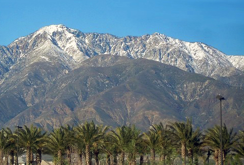 Cucamonga Peak8,859 ft · California1 route2.8 mi awayPhoto: Cliff Hutson; later cropping and color editing by Daniel Case., CC BY 2.0 (via Wikimedia Commons)
- Mount San Antonio10,067 ft · California4 routes3.3 mi away
- Stoddard Peak4,611 ft · California1 route5.9 mi away
Facts about this place
Where it is
- Cucamonga Wilderness · Wilderness
- San Gabriel Mountains National Monument Ranger District · Ranger district
- Angeles National Forest · National forest
- Nearest town
- Lytle Creek, California · 5.4 mi
Source: Wilderness.net boundaries; USFS EDW boundaries; USGS GNIS populated places
Conditions
Active alerts for Angeles National Forest as of Oct 9, 2026:
Planning to Camp? (Stay Limits/Dispersed Camping Restrictions) until Dec. 15, 2026
information · posted Aug 24, 2026
Williamson Rock Area and Trail Closure
caution · posted Aug 24, 2026
Office & Visitor Center Updates - Need Info or Passes?
information · posted Aug 24, 2026
caution · posted Aug 24, 2026
caution · posted Aug 24, 2026
San Gabriel Canyon OHV Area Prohibitions
caution · posted Aug 24, 2026
San Dimas Experimental Forest Closure
caution · posted Aug 24, 2026
Fire Danger Level Elevated to "Very High"
fire-restriction · posted Aug 24, 2026
Rincon-Redbox Road (2N24) Closure
caution · posted Aug 24, 2026
Source: USFS forest alerts
Nearby
 Telegraph Peak TrailHikingPhoto: Moo.The.Cow, CC BY 2.0 (via Flickr)0.2 mi
 Three T'sHikingPhoto: inkknife_2000 (7.5 million views +), CC BY-SA 2.0 (via Wikimedia Commons)0.5 mi
 Three Ts TrailHikingPhoto: inkknife_2000 (7.5 million views +), CC BY-SA 2.0 (via Wikimedia Commons)0.6 mi
- Icehouse CanyonRock climbing1.5 mi
- Manker FlatCamping1.9 mi
- Mount Baldy RoadRock climbing2 mi
- LupineCamping6.1 mi
- Lytle Creek - Cajon Pass Recreation AreaRiver fishing7 mi
Source: Roamze catalog (indexable pages within 10 miles, PostGIS distance)
Is Telegraph Peak open right now?
Alert in the area
The Forest Service lists 7 alerts for Angeles National Forest.
Rincon-Redbox Road (2N24) Closure
Agency alert covering Angeles National Forest · Order 05-01-26-13 · USFS · Angeles National Forest
Fire Danger Level Elevated to "Very High"
Agency alert covering Angeles National Forest · USFS · Angeles National Forest
San Gabriel Canyon OHV Area Prohibitions
Agency alert covering Angeles National Forest · Order 05-01-26-09 · USFS · Angeles National Forest
San Dimas Experimental Forest Closure
Agency alert covering Angeles National Forest · USFS · Angeles National Forest
Eaton Fire Area Closure
Agency alert covering Angeles National Forest · Order 05-01-26-04 · USFS · Angeles National Forest
As of · Source: USFS · Angeles National Forest. Agencies don't list every closure — check before you go.
