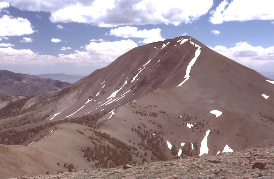
Peavine Canyon
- 15.7 mi
- round trip
- 1,856 ft
- climb
- 8,639 ft
- high point
- Out and back
- route
Is Peavine Canyon open right now?
Closure in the area
There's a closure order in Humboldt-Toiyabe National Forest. It doesn't name Peavine Canyon, so check the source for the area it covers.
Elephant Fire Closure
Agency closure covering Humboldt-Toiyabe National Forest · Order 04-17-26-01-04 · USFS · Humboldt-Toiyabe National Forest
Area, Road, and Trail Closures (Spring Mountains National Recreation Area)
Agency alert covering Humboldt-Toiyabe National Forest · Order 04-17-25-04 · USFS · Humboldt-Toiyabe National Forest
Year-Round Fire Restrictions (Spring Mountains National Recreation Area)
Agency alert covering Humboldt-Toiyabe National Forest · Order 04-17-24-01 · USFS · Humboldt-Toiyabe National Forest
Vehicle Snow Chain Requirements during Inclement Weather (Spring Mountains National Recreation Area)
Agency alert covering Humboldt-Toiyabe National Forest · Order 04-17-23-01 · USFS · Humboldt-Toiyabe National Forest
Rainbow Canyon Flood Diversion Structure Closure (Spring Mountains National Recreation Area)
Agency alert covering Humboldt-Toiyabe National Forest · Order 04-17-15-01 · USFS · Humboldt-Toiyabe National Forest
As of · Source: USFS · Humboldt-Toiyabe National Forest. Agencies don't list every closure — check before you go.
Peavine Canyon is a hard hike in Nevada's Arc Dome Wilderness, part of the Austin-Tonopah Ranger District of the Humboldt-Toiyabe National Forest. The route is an out-and-back that climbs from about 7,000 feet to roughly 8,600 feet, with a total elevation gain of 1,856 feet over a distance of about 15.7 miles. The trail is on natural surface, and horses are allowed, while bikes are not. The trail is open from June 15 through October 30, and the parking area is at the Tom's Canyon Trailhead. That makes it a late-summer and early-fall destination, when the weather is most comfortable. Tom's Canyon Trail lies about 1.7 miles away, and Peavine Summit is about 3.3 miles off. Pablo Canyon and Weeks Canyon are both within about 5 miles. For an overnight base, Peavine Creek Campground is about 6.1 miles away.
Keep exploring — more trails worth the drive
 Photo: Seth Tisue, CC BY-SA 2.0 (via Flickr)
Arc Dome Trail
~19 min drive
9.60-mile out-and-back hike in Nevada with 198 ft gain.
 Photo: Ken Lund from Las Vegas, Nevada, USA, CC BY-SA 2.0 (via Wikimedia Commons)
Adt - Nevada - S - Seg 5
~21 min drive
0.37-mile out-and-back trail in Nevada with 15 ft of elevation gain.
 Photo: Seth Tisue, CC BY-SA 2.0 (via Flickr)
Stewart Creek
~23 min drive
5.20-mile out-and-back trail in Nevada with 1,544 ft elevation gain.
HIKE
Toiyabe Crest Trail
~14 min drive
16.18-mile out-and-back trail in Nevada with 4,596 ft elevation gain and loss.
 Photo: Seth Tisue, CC BY-SA 2.0 (via Flickr)
North Twin River Cutoff
~21 min drive
5.95-mile loop in Nevada with 2,781 ft elevation gain and loss.
Photo: Ken Lund from Las Vegas, Nevada, USA, CC BY-SA 2.0 (via Wikimedia Commons)Fishers Hayfarm Road
~21 min drive
1.94-mile out-and-back trail in Nevada with 144 ft elevation gain.
 Photo: Seth Tisue, CC BY-SA 2.0 (via Flickr)
Columbine
~24 min drive
Columbine is a 4.58-mile out-and-back trail in Nevada with 1,759 feet of elevation gain.
HIKE
Toiyabe Crest Trail
~24 min drive
16.23-mile out-and-back hike on Nevada's Toiyabe Crest Trail with 3,321 ft gain.
HIKE
Tom's Canyon Trail
~3 min drive
14.20-mile out-and-back hike in Nevada with 2,468 ft elevation gain.
HIKE
Peavine Summit
~6 min drive
2.20-mile out-and-back trail to Peavine Summit in Nevada with 456 ft of elevation gain.