Home Valley Campground
Campground
Campground · 4.3 mi from the trail
Augspurger Mountain is a summit of 3,674 feet in Washington's Gifford Pinchot National Forest, about 6 miles from the town of Carson. It sits within the national forest's jurisdiction, and the Augspurger Trail lies about 2 miles away, making it the natural route for reaching the top. Summer is the most comfortable time to go. Typical averages from a nearby weather station at Snowden, which sits roughly 1,260 feet lower, show July and August highs around 79°F with lows near 49°F. That station's figures are not adjusted for the summit's higher elevation, so temperatures on top run cooler. The Augspurger Trail is the closest neighbor, and the Grassy Knoll hike is about 2.5 miles off. Climbers can head to Inca Boulder, about 2.6 miles away, and paddlers will find the Little Wind River about 2.2 miles from the summit.
Home Valley Campground
Campground
 If it rainsJmasterson, CC BY-SA 3.0 · Wikimedia Commons
Western Antique Aeroplane & Automobile Museum
Museum
Aviation and automobile museum in Oregon, United States
Places © OpenStreetMap contributors · Photos: Jmasterson, CC BY-SA 3.0 (commons)
More in Trout LakeDaily highs and lows, wind and the chance of precipitation at the summit and route start for the next 7 days, from the Open-Meteo model.
Elevation from USGS 3D Elevation Program terrain data (about 10 m resolution).
3,674 ft (1,120 m).
One: Augspurger Trail.

 Moss Creek campgroundCampingPhoto: Recreation.gov (RIDB) / public domain4.6 mi
Source: Roamze catalog (indexable pages within 10 miles, PostGIS distance)
Mount DefianceSummit · ~12 min drivePhoto: Mehmet Emre Yavuz Meyavuz, CC BY-SA 3.0 (via Wikimedia Commons) Greenleaf PeakSummit · ~22 min drivePhoto: Walter Siegmund (talk), CC BY-SA 3.0 (via Wikimedia Commons)
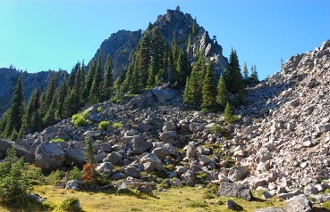 Lemei RockSummit · ~32 min drivePhoto: FizzyUnicorn, CC BY-SA 3.0 (via Wikimedia Commons)
 Table MountainSummit · ~24 min drivePhoto: Walter Siegmund (talk), CC BY-SA 3.0 (via Wikimedia Commons)
Best months: April–October. Best months have typical highs of 55–85 °F, lows of 30 °F or warmer (32 °F where the station doesn't record snow), at most one snowy day and no more than 12 wet days.
Jan
38° / 25°
Feb
42° / 26°
Mar
48° / 30°
Apr
55° / 35°
May
63° / 40°
Jun
68° / 44°
Jul
79° / 49°
Aug
79° / 49°
Sep
72° / 45°
Oct
58° / 37°
Nov
45° / 31°
Dec
36° / 25°
Typical high / low (°F) and days with rain or snow, 1991–2020. Measured at Snowden, WA, 17.8 mi away at 2,415 ft. The station sits about 1,300 ft lower than this place, so expect it a little cooler here. This station doesn't record snowfall. Source: NOAA NCEI U.S. Climate Normals 1991–2020.

