Lake Wapiki Camping Area
Campground
Campground · 0.5 mi from the trail
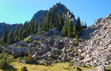 Photo: FizzyUnicorn, CC BY-SA 3.0 (via Wikimedia Commons)
Alert in the area
The Forest Service lists 6 alerts for Gifford Pinchot National Forest.
Fire Restrictions
Agency alert covering Gifford Pinchot National Forest · USFS · Gifford Pinchot National Forest
Seasonal Road Closures
Agency alert covering Gifford Pinchot National Forest · USFS · Gifford Pinchot National Forest
Road Repairs & Road Closures in 2026
Agency alert covering Gifford Pinchot National Forest · USFS · Gifford Pinchot National Forest
Washout on Forest Road 93
Agency alert covering Gifford Pinchot National Forest · USFS · Gifford Pinchot National Forest
Upper State Route 504 closed at milepost 45.2 due to large slide
Agency alert covering Gifford Pinchot National Forest · USFS · Gifford Pinchot National Forest
As of · Source: USFS · Gifford Pinchot National Forest. Agencies don't list every closure — check before you go.
Lemei Rock is a summit in Skamania County, Washington, inside the Indian Heaven Wilderness on the Mt. Adams Ranger District of the Gifford Pinchot National Forest. The nearest town is Trout Lake, 11.2 miles away. The Forest Service manages the land. Trails and camping sit close by. Wapiki Lake Trail #34A is 0.5 miles away, Lemei Trail #34 is 0.8 miles, and Lemei Lake is 1 mile off. Cultus Creek Campground, 2 miles away, is the closest campground.
Lake Wapiki Camping Area
Campground
Trout Lake Hall
Restaurant
Carson Art Garage
Gallery
Places © OpenStreetMap contributors
More in Trout LakeDaily highs and lows, wind and the chance of precipitation at the summit for the next 7 days, from the Open-Meteo model.
Elevation from USGS 3D Elevation Program terrain data (about 10 m resolution).
We don't know of a mapped trail or route to the summit of Lemei Rock. Plan the approach with local maps, a guidebook or a local guide, and check conditions before you go.
5,924 ft (1,806 m).
We don't know of a mapped trail or route to the summit. Plan the approach with local maps, a guidebook or a local guide.
 Lemei LakeHikingPhoto: U.S. Forest Service- Pacific Northwest Region, Public domain (via Wikimedia Commons)1 mi
Source: Roamze catalog (indexable pages within 10 miles, PostGIS distance)
 Mount AdamsSummit · ~31 min drivePhoto: USGS Photo by R. Iverson, USGS/CVO, Public domain (via Wikimedia Commons)
 Greenleaf PeakSummit · ~40 min drivePhoto: Walter Siegmund (talk), CC BY-SA 3.0 (via Wikimedia Commons)
 Mount Saint HelensSummit · ~41 min drivePhoto: U.S. Forest Service- Pacific Northwest Region, Public domain (via Wikimedia Commons)
 Mount DefianceSummit · ~44 min drivePhoto: Mehmet Emre Yavuz Meyavuz, CC BY-SA 3.0 (via Wikimedia Commons)
 Table MountainSummit · ~43 min drivePhoto: Walter Siegmund (talk), CC BY-SA 3.0 (via Wikimedia Commons)

