Mineral Basin Dispersed Area
Campground
Campground · 1.4 mi from the trail
No closures listed
The Forest Service lists no closures for Uinta-Wasatch-Cache National Forest.
As of · Source: USFS · Uinta-Wasatch-Cache National Forest. Agencies don't list every closure — check before you go.
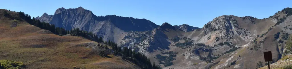
Ant Knolls is a summit of 9,878 feet in the Pleasant Grove Ranger District of Uinta-Wasatch-Cache National Forest in Utah, about 3.4 miles from the town of Alta. Summer is the most comfortable time to go. Typical July averages from a nearby weather station at Silver Lake run to a high of 72°F and a low of 47°F, and the summit sits higher than that station, so expect it to run a little cooler. The Ant Knolls Trail starts just 0.4 miles away, and the Big Flat Springs Trail is 0.8 miles off. Within about 3 miles you'll also find Lake Catherine and the Devil's Castle climbing area.
Mineral Basin Dispersed Area
Campground
 If it rainsSaalebaer, CC0 · Wikimedia Commons
Park City Museum
Museum
Places © OpenStreetMap contributors · Photos: Saalebaer, CC0 (commons)
More in HeberDaily highs and lows, wind and the chance of precipitation at the summit and route start for the next 7 days, from the Open-Meteo model.
Elevation from USGS 3D Elevation Program terrain data (about 10 m resolution).
9,878 ft (3,011 m).
One: Ridge Trail.


 Devil's CastleRock climbingPhoto: Curtis Abert, CC BY 2.0 (via Flickr)2.5 mi
 Tacos Diablos BoulderRock climbingPhoto: paulinkenbrandt, CC BY-SA 2.0 (via Flickr)2.7 mi
 Albion BasinCampingPhoto: Recreation.gov (RIDB) / public domain2.8 mi
Source: Roamze catalog (indexable pages within 10 miles, PostGIS distance)
Sunset PeakSummit · ~4 min drivePhoto: Andrey Zharkikh, CC BY 2.0 (via Wikimedia Commons)Mount TuscaroraSummit · ~5 min drivePhoto: Brian Lauer, CC BY 2.0 (via Wikimedia Commons)Clayton PeakSummit · ~5 min drivePhoto: drdanielweir, CC BY 3.0 (via Wikimedia Commons) Mount BaldySummit · ~6 min drivePhoto: michaelwm25, CC BY 3.0 (via Wikimedia Commons)
 Hidden PeakSummit · ~7 min drivePhoto: VeggieGarden, CC BY-SA 4.0 (via Wikimedia Commons)
 Superior PeakSummit · ~10 min drivePhoto: Derrellwilliams, CC BY-SA 4.0 (via Wikimedia Commons)
 The PfeifferhornSummit · ~12 min drivePhoto: Itineranttrader, Public domain (via Wikimedia Commons)
 Kesler PeakSummit · ~12 min drivePhoto: Derrellwilliams, CC BY-SA 4.0 (via Wikimedia Commons)
 Lone PeakSummit · ~17 min drivePhoto: Climbjm at English Wikipedia, Public domain (via Wikimedia Commons)
 Mount RaymondSummit · ~17 min drivePhoto: Derrellwilliams, CC BY-SA 4.0 (via Wikimedia Commons)
Also worth it near here
Best months: June–September. Best months have typical highs of 55–85 °F, lows of 30 °F or warmer (32 °F where the station doesn't record snow), at most one snowy day and no more than 12 wet days.
Jan
31° / 11°
Feb
31° / 12°
Mar
37° / 17°
Apr
43° / 22°
May
52° / 30°
Jun
64° / 39°
Jul
72° / 47°
Aug
71° / 46°
Sep
62° / 38°
Oct
49° / 28°
Nov
37° / 18°
Dec
30° / 11°
Typical high / low (°F) and days with rain or snow, 1991–2020. Measured at Silver Lake Brighton, UT, 3.5 mi away at 8,740 ft. The station sits about 1,100 ft lower than this place, so expect it a little cooler here. This station doesn't record snowfall. Source: NOAA NCEI U.S. Climate Normals 1991–2020.

