Ptarmigan Peak
 Photo: Thomson200, CC0 (via Wikimedia Commons)
- 12,496 ft
- summit
- 3
- ways up
- Forest Service
- managed by
Ptarmigan Peak is a summit of 12,496 feet in Colorado's Arapaho National Forest, about 4 miles from the town of Silverthorne. The Forest Service manages the land. Summer is the most comfortable time to go. Typical averages from the nearby Climax weather station, which sits about 1,150 feet lower, show July highs around 67°F with lows near 40°F and no snow days. Winter is cold and snowy, with highs in the upper 20s and snow on about half the days from December through February. Ute Peak lies just 0.1 mile away, and Ptarmigan Pass is about 1.2 miles off. For an overnight stay, Windy Point Group Campground is roughly 5.8 miles away, and the Blue River offers fishing about 4.9 miles from the peak.
Conditions and forecast
Daily highs and lows, wind and the chance of precipitation at the summit and route start for the next 7 days, from the Open-Meteo model.
- Summit elevation
- 12,496 ft
- Land manager
- Forest Service
Elevation from USGS 3D Elevation Program terrain data (about 10 m resolution).
- Ptarmigan PeakEasyabout 564 ft of climbing2.2 mi round trip
- Ute PeakHardFrom UTE PASS (about 12,470 ft) · about 361 ft of climbing25.0 mi round trip
- Ute PeakHardFrom Ute Peak Trailhead (about 8,880 ft) · about 4,131 ft of climbing27.2 mi round trip
Compare the routes Ptarmigan Peak Ute Peak Ute Peak Starts at — UTE PASS Ute Peak Trailhead Climbing About 564 ft About 361 ft About 4,131 ft Round trip 2.2 mi 25.0 mi 27.2 mi Difficulty Easy Hard Hard Terrain Hike Hike Hike Season Year-round Year-round June 1 – November 15 Map © Mapbox © OpenStreetMap contributors Questions about Ptarmigan Peak
How tall is Ptarmigan Peak?
12,496 ft (3,809 m).
How many routes go to the summit of Ptarmigan Peak?
3: Ptarmigan Peak, Ute Peak and Ute Peak.
What is the shortest route up Ptarmigan Peak?
Ptarmigan Peak, about 2.2 mi round trip.
Where do the routes up Ptarmigan Peak start?
Ute Peak starts at UTE PASS (about 12,470 ft). Ute Peak starts at Ute Peak Trailhead (about 8,880 ft).
When is the best time to climb Ptarmigan Peak?
Year-round.
 Tenderfoot Mountain11,439 ft · Colorado1 route4.0 mi awayPhoto: Runningonbrains, CC BY-SA 3.0 (via Wikimedia Commons)
 Lake Hill9,359 ft · Colorado3 routes5.8 mi awayPhoto: Clyde Charles Brown, CC BY-SA 4.0 (via Wikimedia Commons)
- Hagar Mountain13,193 ft · Colorado1 route5.8 mi away
 Pettingell Peak13,552 ft · Colorado1 route7.0 mi awayPhoto: Kylie Stewart, CC BY 2.0 (via Wikimedia Commons)
 Buffalo Mountain12,779 ft · Colorado1 route8.1 mi awayPhoto: kelley.tara, CC BY 2.0 (via Wikimedia Commons)
- Red Peak13,184 ft · Colorado1 route8.6 mi away
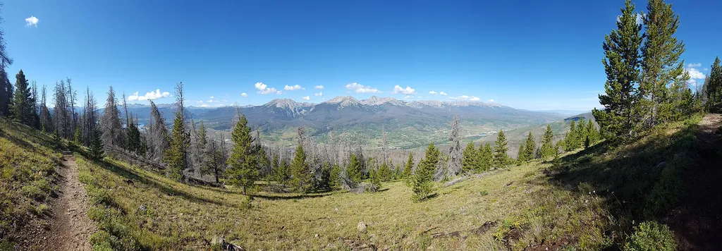 Ute PeakHikingPhoto: Mcphail492 — Wikimedia Commons (CC BY-SA 4.0)0.1 mi
- Ptarmigan PassHiking1.2 mi
- Blue RiverRiver fishing4.9 mi
- Windy Point Group CampgroundCamping5.8 mi
- Blue River CampgroundCamping6.1 mi
- Swan Mountain RoadRock climbing6.3 mi
- Old Dillon Reservoir #87Lake fishing6.4 mi
- Keystone a.k.a. MontezumaRock climbing6.8 mi
Source: Roamze catalog (indexable pages within 10 miles, PostGIS distance)
- Tenderfoot MountainSummit · ~7 min drivePhoto: Runningonbrains, CC BY-SA 3.0 (via Wikimedia Commons)
- Lake HillSummit · ~10 min drivePhoto: Clyde Charles Brown, CC BY-SA 4.0 (via Wikimedia Commons)
- Pettingell PeakSummit · ~12 min drivePhoto: Kylie Stewart, CC BY 2.0 (via Wikimedia Commons)
 Mount BethelSummit · ~14 min drivePhoto: Joanna Lee Osborn, CC BY 2.0 (via Wikimedia Commons)
 Mount SniktauSummit · ~16 min drivePhoto: Xnatedawgx, CC BY-SA 3.0 (via Wikimedia Commons)
 Royal MountainSummit · ~16 min drivePhoto: Clyde Charles Brown, CC BY-SA 4.0 (via Wikimedia Commons)
 Grizzly PeakSummit · ~17 min drivePhoto: Ben Mason from Denver, CC BY 2.0 (via Wikimedia Commons)
 Mount ParnassusSummit · ~19 min drivePhoto: Xnatedawgx, CC BY-SA 3.0 (via Wikimedia Commons)
 Peak OneSummit · ~19 min drivePhoto: Kahunapule Michael Johnson, CC BY-SA 2.0 (via Wikimedia Commons)
 Torreys PeakSummit · ~20 min drivePhoto: Pimlico27, CC BY-SA 4.0 (via Wikimedia Commons)
Best time to visit Ptarmigan Peak
No month here meets our mild-weather rule. Best months have typical highs of 55–85 °F, lows of 30 °F or warmer (32 °F where the station doesn't record snow), at most one snowy day and no more than 12 wet days.
Jan
27° / 3°
15 wet · 15 snow
Feb
29° / 3°
15 wet · 15 snow
Mar
35° / 8°
14 wet · 14 snow
Apr
40° / 15°
13 wet · 13 snow
May
49° / 25°
10 wet · 8 snow
Jun
61° / 34°
8 wet · 2 snow
Jul
67° / 40°
13 wet
Aug
64° / 39°
15 wet
Sep
58° / 32°
11 wet · 2 snow
Oct
47° / 21°
9 wet · 7 snow
Nov
35° / 11°
12 wet · 12 snow
Dec
27° / 3°
15 wet · 15 snow
Typical high / low (°F) and days with rain or snow, 1991–2020. Measured at Climax, CO, 24 mi away at 11,344 ft. The station sits about 1,200 ft lower than this place, so expect it a little cooler here. Source: NOAA NCEI U.S. Climate Normals 1991–2020.

