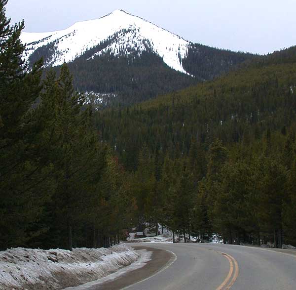
Baker Mountain
 Photo: Bob Denaro, CC BY 2.0 (via Wikimedia Commons)
- 9,824 ft
- summit
- Forest Service
- managed by
- Jun–Sep
- best months
Is Baker Mountain open right now?
Alert in the area
The Forest Service lists 3 alerts for Medicine Bow-Routt National Forest.
Access Impact: Big Creek Lakes Dam Project
Agency alert covering Medicine Bow-Routt National Forest · USFS · Medicine Bow-Routt National Forest
Trail & Access Impact: Stillwater Reservoir Project
Agency alert covering Medicine Bow-Routt National Forest · USFS · Medicine Bow-Routt National Forest
Snowy Range - 2026 Active Vegetation Operations
Agency alert covering Medicine Bow-Routt National Forest · USFS · Medicine Bow-Routt National Forest
As of · Source: USFS · Medicine Bow-Routt National Forest. Agencies don't list every closure — check before you go.
Baker Mountain is a summit of 9,824 feet in the Yampa Ranger District of the Medicine Bow-Routt National Forest in Colorado, managed by the Forest Service. The nearest town is Steamboat Springs, about 14 miles away. Summer is the most comfortable time to visit. Typical averages from a nearby weather station in Spicer show July highs around 77°F and lows near 42°F. That station sits well below the summit, so temperatures up high run cooler. Winters there are severe, with January highs averaging about 28°F. Rabbit Ears Pass Camp and Dumont Lake Campground are both about 2 miles away. The Routt Divide hike is roughly 5 miles off, and the Lost Lake hike is about 6 miles away.
Conditions and forecast
Daily highs and lows, wind and the chance of precipitation at the summit for the next 7 days, from the Open-Meteo model.
- Summit elevation
- 9,824 ft
- Land manager
- Forest Service
Elevation from USGS 3D Elevation Program terrain data (about 10 m resolution).
We don't know of a mapped trail or route to the summit of Baker Mountain. Plan the approach with local maps, a guidebook or a local guide, and check conditions before you go.
Questions about Baker Mountain
How tall is Baker Mountain?
9,824 ft (2,994 m).
Is there a trail to the top of Baker Mountain?
We don't know of a mapped trail or route to the summit. Plan the approach with local maps, a guidebook or a local guide.
 Mount Werner10,573 ft · Colorado1 route9.2 mi awayPhoto: Jeffrey Beall, CC BY 4.0 (via Wikimedia Commons)
- Buffalo Mountain10,390 ft · Colorado1 route12 mi away
- Soda Mountain10,811 ft · Colorado1 route14 mi away
- Howelsen Hill7,173 ft · Colorado2 routes15 mi away
- Searight Mountain10,746 ft · Colorado1 route27 mi away
- Farview Mountain12,237 ft · Colorado1 route34 mi away
- Rabbit Ears Pass CampCamping2 mi
- Dumont Lake CampgroundCamping2.2 mi
- Muddy CreekRock climbing2.2 mi
- Routt DivideHiking4.7 mi
- Other Rose DomeRock climbing5.8 mi
 Lost LakeHikingPhoto: threeagoutdoors, CC BY 4.0 (via Wikimedia Commons)6 mi
- Colorado CreekCanoeing6.2 mi
- Harrison CreekCanoeing7.2 mi
Source: Roamze catalog (indexable pages within 10 miles, PostGIS distance)
 Whiteley PeakSummit · ~12 min drivePhoto: Jeffrey Beall, CC BY 4.0 (via Wikimedia Commons)
- Mount WernerSummit · ~16 min drivePhoto: Jeffrey Beall, CC BY 4.0 (via Wikimedia Commons)
 Elk MountainSummit · ~40 min drivePhoto: Jeffrey Beall, CC BY 4.0 (via Wikimedia Commons)
 Parkview MountainSummit · ~42 min drivePhoto: Matthew Trump, CC BY-SA 3.0 (via Wikimedia Commons)
 Radial MountainSummit · ~50 min drivePhoto: Trellbailey, CC BY-SA 4.0 (via Wikimedia Commons)
 Mount ZirkelSummit · ~54 min drivePhoto: TomKonrad, CC BY-SA 4.0 (via Wikimedia Commons)
 Flat Top MountainSummit · ~1h 1m drivePhoto: John Holm from Leadville, CO, USA, CC BY 2.0 (via Wikimedia Commons)
 Mount CumulusSummit · ~1h 3m drivePhoto: mark byzewski, CC BY 2.0 (via Wikimedia Commons)
 Green KnollSummit · ~1h 4m drivePhoto: mark byzewski, CC BY 2.0 (via Wikimedia Commons)
 Howard MountainSummit · ~1h 4m drivePhoto: KimonBerlin, CC BY-SA 2.5 (via Wikimedia Commons)
Best time to visit Baker Mountain
Best months: June–September. Best months have typical highs of 55–85 °F, lows of 30 °F or warmer (32 °F where the station doesn't record snow), at most one snowy day and no more than 12 wet days.
Jan
28° / 7°
8 wet
Feb
31° / 9°
8 wet
Mar
40° / 15°
8 wet
Apr
49° / 23°
9 wet
May
59° / 30°
10 wet
Jun
71° / 36°
8 wet
Jul
77° / 42°
9 wet
Aug
76° / 40°
11 wet
Sep
68° / 34°
8 wet
Oct
55° / 25°
7 wet
Nov
39° / 16°
8 wet
Dec
29° / 9°
8 wet
Typical high / low (°F) and days with rain or snow, 1991–2020. Measured at Spicer, CO, 10.5 mi away at 8,385 ft. The station sits about 1,400 ft lower than this place, so expect it a little cooler here. This station doesn't record snowfall. Source: NOAA NCEI U.S. Climate Normals 1991–2020.
