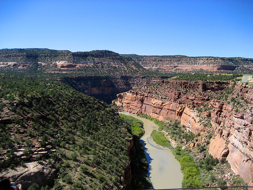
 Photo: Argyleist. Original uploader was Argyleist at en.wikipedia, CC BY 3.0 (via Wikimedia Commons)
Paddling · 7 spots
Featured spots
Photo: Argyleist. Original uploader was Argyleist at en.wikipedia, CC BY 3.0 (via Wikimedia Commons)Canoeing
Dolores River
Norwood, Colorado
 Photo: Cawright2007, CC BY-SA 3.0 (via Wikimedia Commons)
Canoeing
San Miguel River
Norwood, Colorado

Canoeing
Beaver Creek
Norwood, Colorado

Canoeing
Disappointment Creek
Norwood, Colorado
Canoeing
Horsefly Creek
Norwood, Colorado
All spots · 7 spots


Keep exploring — more water worth the drive
Photo: Cawright2007, CC BY-SA 3.0 (via Wikimedia Commons)San Miguel River
~16 min drive
San Miguel River is a 2.3-mile paddling stretch near Norwood, Colorado. It flows year-round. USGS models an average flow of about 309 cfs and a gradient of about 138.1 feet per mile.
House Creek Boating Site
~1h 6m drive
A worthwhile stop near Colorado.
Photo: Argyleist. Original uploader was Argyleist at en.wikipedia, CC BY 3.0 (via Wikimedia Commons)Dolores River
~19 min drive
Dolores River is a 13-mile paddling stretch near Norwood, Colorado. It flows year-round. USGS models an average flow of about 626 cfs and a gradient of about 163.6 feet per mile. Land along it is managed by the U.S. Forest Service.
Mcphee Boating Site
~1h 8m drive
A worthwhile stop near Colorado.
 Photo: Jeffrey Beall, CC BY 4.0 (via Wikimedia Commons)
Leopard Creek
~31 min drive
Leopard Creek is a 14-mile paddling stretch near Placerville, Colorado. It flows year-round. USGS models an average flow of about 56 cfs and a gradient of about 146.0 feet per mile.
Silver Jack Fishing Access
~1h 16m drive
A worthwhile stop near Colorado.
 Photo: Jeffrey Beall, CC BY 4.0 (via Wikimedia Commons)
West Dolores River
~37 min drive
West Dolores River is a 12-mile paddling stretch near Dolores, Colorado. It flows year-round. USGS models an average flow of about 64 cfs and a gradient of about 241.8 feet per mile. Land along it is managed by the U.S. Forest Service.
Haviland Lake Boating Site
~1h 17m drive
A worthwhile stop near Colorado.
 Photo: Boyd Norton, Public domain (via Wikimedia Commons)
East Fork Dallas Creek
~47 min drive
East Fork Dallas Creek is a 11-mile paddling stretch near Ridgway, Colorado. It is intermittent and may run dry in some seasons. USGS models an average flow of about 34 cfs and a gradient of about 318.4 feet per mile.
Escalante Bridge
~1h 25m drive
Escalante Bridge is a boat launch in Colorado.
 Photo: Sally Pearce, Colorado Department of Transportation; brightened and color-corrected by Howcheng, Public domain (via Wikimedia Commons)
Uncompahgre River
~55 min drive
Uncompahgre River is a 13-mile paddling stretch near Montrose, Colorado. It flows year-round. USGS models an average flow of about 281 cfs and a gradient of about 280.1 feet per mile. Land along it is managed by the Bureau of Land Management.
 Photo: Jeffrey Beall, CC BY 4.0 (via Wikimedia Commons)
Hermosa Creek
~1h 10m drive
Hermosa Creek is a 29-mile paddling stretch near Durango, Colorado. It flows year-round. USGS models an average flow of about 270 cfs and a gradient of about 134.6 feet per mile. Land along it is managed by the U.S. Forest Service.
