Lone Cone Cabin
Campground
Campground · 2.7 mi from the trail
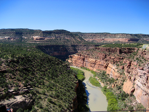 Photo: Argyleist. Original uploader was Argyleist at en.wikipedia, CC BY 3.0 (via Wikimedia Commons)
Dolores River (Gateway, CO to Dewey Bridge, UT) · river launch
Reserve on Recreation.govClosure in the area
There's a closure order in Grand Mesa, Uncompahgre and Gunnison National Forests. It doesn't name Dolores River, so check the source for the area it covers (2 listed).
Gold Mountain Wildfire Roads and Trails Closure Order v 4.0
Agency closure covering Grand Mesa, Uncompahgre and Gunnison National Forests · USFS · Grand Mesa, Uncompahgre and Gunnison National Forests
Ophir Pass Road Closure
Agency closure covering Grand Mesa, Uncompahgre and Gunnison National Forests · USFS · Grand Mesa, Uncompahgre and Gunnison National Forests
Potter Basin Road Closure Order
Agency alert covering Grand Mesa, Uncompahgre and Gunnison National Forests · USFS · Grand Mesa, Uncompahgre and Gunnison National Forests
Beaver Park Road Closure Order
Agency alert covering Grand Mesa, Uncompahgre and Gunnison National Forests · USFS · Grand Mesa, Uncompahgre and Gunnison National Forests
TERMINATION OF ORDER - FIRE RESTRICTIONS
Agency alert covering Grand Mesa, Uncompahgre and Gunnison National Forests · USFS · Grand Mesa, Uncompahgre and Gunnison National Forests
As of · Source: USFS · Grand Mesa, Uncompahgre and Gunnison National Forests. Agencies don't list every closure — check before you go.
Dolores River is a 13-mile paddling stretch near Norwood, Colorado. It flows year-round. USGS models an average flow of about 626 cfs and a gradient of about 163.6 feet per mile. Land along it is managed by the U.S. Forest Service.
Lone Cone Cabin
Campground
Telluride Arts District
Gallery
Places © OpenStreetMap contributors, Places © Overture Maps Foundation
More in TellurideNot on Roamze yet. Their page has how to reach them.
Source: Roamze catalog (indexable pages within 10 miles, PostGIS distance)
 West Dolores RiverCanoeing · ~18 min drivePhoto: Jeffrey Beall, CC BY 4.0 (via Wikimedia Commons)
 Leopard CreekCanoeing · ~28 min drivePhoto: Jeffrey Beall, CC BY 4.0 (via Wikimedia Commons)
 San Miguel RiverCanoeing · ~34 min drivePhoto: Cawright2007, CC BY-SA 3.0 (via Wikimedia Commons)
 East Fork Dallas CreekCanoeing · ~40 min drivePhoto: Boyd Norton, Public domain (via Wikimedia Commons)
 Hermosa CreekCanoeing · ~52 min drivePhoto: Jeffrey Beall, CC BY 4.0 (via Wikimedia Commons)

