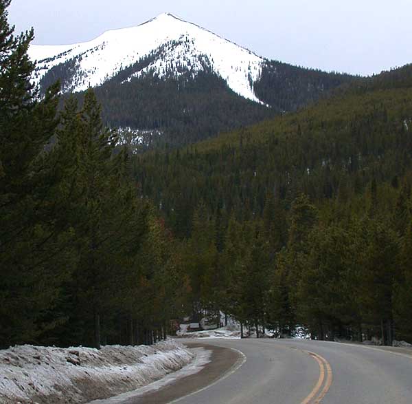
Parkview
 Photo: cogdogblog, CC BY 2.0 (via Wikimedia Commons)
- 3.6 mi
- round trip
- 624 ft
- climb
- 10,361 ft
- high point
- Out and back
- route
- Jun–Aug
- best months
Is Parkview open right now?
Alert in the area
The Forest Service lists 3 alerts for Arapaho and Roosevelt National Forests.
Fire Restrictions
Agency alert covering Arapaho and Roosevelt National Forests · USFS · Arapaho and Roosevelt National Forests
Fire Restrictions
Agency alert covering Sulphur Ranger District · USFS · Sulphur Ranger District
Permanent Recreational Shooting Order
Agency alert covering Sulphur Ranger District · Order 02-10-00-25-02 · USFS · Sulphur Ranger District
As of · Source: USFS · Arapaho and Roosevelt National Forests. Agencies don't list every closure — check before you go.
Parkview is an easy out-and-back hike on the Forest Service trails of the Sulphur Ranger District in Colorado's Arapaho and Roosevelt National Forests. The trail runs about 3.6 miles round trip, with a one-way climb of 624 feet from the low point at 9,550 feet to the high point at 10,361 feet. The route is a natural-surface trail, and it works for hikers, riders and horseback travelers. That makes it a flexible choice for a day on foot, on a bike or on horseback, and the trailhead is named Parkview Trailhead. Summer and early fall are the most comfortable times to go. Typical averages from a nearby weather station run to highs around 73°F in July and 64°F in September, and the trail is open from about June 1 to November 15. Other outings sit close by. Parkview Creek and Willow Pass Trail are both within a mile. Denver Creek Campground is about 6.7 miles away, and the Trail Creek mountain biking area is about 4.6 miles away.
Local outfitters
- Alpine Lodge at Red Feather Lakes41 mi away
- Rancho Del Rio41 mi away
Not on Roamze yet. Their page has how to reach them.
Best time to go · Jun–Aug
Best time to visit Parkview
Best months: June–August. Best months have typical highs of 55–85 °F, lows of 30 °F or warmer (32 °F where the station doesn't record snow), at most one snowy day and no more than 12 wet days.
Jan
29° / 3°
11 wet
Feb
30° / 5°
11 wet
Mar
38° / 12°
10 wet
Apr
45° / 20°
10 wet
May
55° / 27°
9 wet
Jun
67° / 33°
8 wet
Jul
73° / 40°
10 wet
Aug
72° / 38°
11 wet
Sep
64° / 31°
9 wet
Oct
51° / 22°
8 wet
Nov
38° / 12°
10 wet
Dec
30° / 4°
12 wet
Typical high / low (°F) and days with rain or snow, 1991–2020. Measured at Gould 4se Sfsp, CO, 11.9 mi away at 9,000 ft. The station sits about 1,400 ft lower than this place, so expect it a little cooler here. This station doesn't record snowfall. Source: NOAA NCEI U.S. Climate Normals 1991–2020.
Keep exploring — more trails worth the drive
Photo: cogdogblog, CC BY 2.0 (via Wikimedia Commons)PARKVIEW CREEK
Next door
14.4-mile out-and-back trail at 9,839 ft elevation in Colorado
Photo: cogdogblog, CC BY 2.0 (via Wikimedia Commons)Willow Pass Trail
~1 min drive
1.84-mile out-and-back trail in Colorado with 373 ft elevation gain and loss.
HIKE
West Stillwater Trail
~8 min drive
9.22-mile hike in Colorado with 1,800 ft elevation gain and 9,200 ft max elevation.
HIKE
SNYDER CREEK LOOP
~11 min drive
49.02-mile out-and-back trail in Colorado with 7,448 ft elevation gain
HIKE
Trail Creek
~8 min drive
7.3 mi · Hard
 Photo: Thomas — CC BY-SA 2.0 (via Flickr)
Gilsonite Trail
~14 min drive
3.65-mile trail in Colorado with 800 ft of elevation gain.
HIKE
KAUFFMAN CREEK SPUR
~9 min drive
3.48-mile out-and-back trail in Colorado with 1,074 ft elevation gain.
HIKE
LITTLE GRAVEL MOUNTAIN SPUR
~11 min drive
23.78-mile out-and-back trail in Colorado with 3,568 ft gain/loss.
HIKE
Buffalo Creek
~11 min drive
11.12-mile out-and-back trail in Colorado with 951 ft elevation gain.
HIKE
South Trail Creek
~8 min drive
2.20-mile out-and-back trail in Colorado with 296 ft elevation gain.