Zion Glamping Adventures
Campground
Campground · 4.9 mi from the trail
Canaan Mountain Trail is a 5.2-mile out-and-back hike in the Canaan Mountain Wilderness, part of the Bureau of Land Management's St. George Field Office in southern Utah. The trail starts at about 5,770 feet and climbs steadily to a high point of 6,090 feet, with a total elevation gain of 1,184 feet for the round trip. The steepest stretch comes at about 2.3 miles, where the grade reaches 17%, and the route is rated moderate. Spring and fall are the most comfortable times to go. Typical averages from a nearby weather station in Colorado City, Arizona, show October highs around 72°F with lows near 42°F, while July averages a high of 95°F. That station sits about 1,100 feet lower than the trail, so temperatures on the mountain run cooler. The hike takes about 2.5 hours. Within a few miles are Squirrel Canyon Trail and Trail to Water Canyon Arch, and the Colorado City Area climbing area lies about 6 miles away. Watchman Campground, roughly 9 miles off, offers a place to stay.
Zion Glamping Adventures
Campground
 If it rainsDon Graham from Redlands, CA, USA - God bless it!, CC BY-SA 2.0 · Wikimedia Commons
Places © OpenStreetMap contributors · Photos: Don Graham from Redlands, CA, USA - God bless it!, CC BY-SA 2.0 (commons)
More in HurricaneNot on Roamze yet. Their page has how to reach them.
 Squirrel Canyon TrailHikingPhoto: BLMUtah, Public domain (via Wikimedia Commons)2.4 mi
 Trail to Water Canyon ArchHikingPhoto: BLMUtah, Public domain (via Wikimedia Commons)3 miWater Canyon TrailHikingPhoto: BLMUtah, Public domain (via Wikimedia Commons)3.5 mi
 Colorado City AreaRock climbingPhoto: Rodrigo Paredes from Ciudad Autónoma de Buenos Aires, Argentina, CC BY 2.0 (via Wikimedia Commons)5.8 mi
 Rock WorshipRock climbingPhoto: Ken Lund from Reno, Nevada, USA, CC BY-SA 2.0 (via Wikimedia Commons)5.9 mi
 The WatchmanRock climbingPhoto: Christopher Michel, CC BY 2.0 (via Wikimedia Commons)8 mi
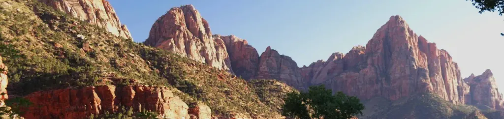 Watchman CampgroundCampingPhoto: Recreation.gov (RIDB) / public domain9 mi
Source: Roamze catalog (indexable pages within 10 miles, PostGIS distance)
Squirrel Canyon TrailHiking · ~4 min drivePhoto: BLMUtah, Public domain (via Wikimedia Commons)Trail to Water Canyon ArchHiking · ~5 min drivePhoto: BLMUtah, Public domain (via Wikimedia Commons)Water Canyon TrailHiking · ~6 min drivePhoto: BLMUtah, Public domain (via Wikimedia Commons) Wire Mesa Loop TrailHiking · ~16 min drivePhoto: Don Graham from Redlands, CA, USA - God bless it!, CC BY-SA 2.0 (via Wikimedia Commons)
 Nung’wu Poa (Paiute) Trail - Phase 2Hiking · ~14 min drivePhoto: Ken Lund, CC BY-SA 2.0 (via Wikimedia Commons)
 Scoggins Wash TrailHiking · ~20 min drivePhoto: Fredlyfish4, CC BY-SA 4.0 (via Wikimedia Commons)
 Many Pools HikeHiking · ~17 min drivePhoto: Ken Lund from Reno, Nevada, USA, CC BY-SA 2.0 (via Wikimedia Commons)
Also worth it near here
 South MountainSummit · ~4 min drivePhoto: George A. Grant, Public domain (via Wikimedia Commons)Colorado City AreaRock climbing · ~10 min drivePhoto: Rodrigo Paredes from Ciudad Autónoma de Buenos Aires, Argentina, CC BY 2.0 (via Wikimedia Commons)
Best months: March–May and September–October. Best months have typical highs of 55–85 °F, lows of 30 °F or warmer (32 °F where the station doesn't record snow), at most one snowy day and no more than 12 wet days.
Jan
49° / 24°
6 wet
Feb
53° / 28°
7 wet
Mar
61° / 33°
7 wet
Apr
68° / 38°
5 wet
May
78° / 46°
3 wet
Jun
89° / 54°
3 wet
Jul
95° / 62°
5 wet
Aug
92° / 62°
6 wet
Sep
84° / 54°
4 wet
Oct
72° / 42°
4 wet
Nov
59° / 31°
4 wet
Dec
48° / 24°
5 wet
Typical high / low (°F) and days with rain or snow, 1991–2020. Measured at Colorado City, AZ, 6.7 mi away at 5,001 ft. The station sits about 1,100 ft lower than this place, so expect it a little cooler here. This station doesn't record snowfall. Source: NOAA NCEI U.S. Climate Normals 1991–2020.
Map and trail data © OpenStreetMap contributors
