Bears Ears Loop
- 5.0 mi
- round trip
- 320 ft
- climb
- 8,099 ft
- high point
- Out and back
- route
- Apr–Jun, Aug–Oct
- best months
Is Bears Ears Loop open right now?
Alert in the area
The Forest Service lists an alert for Monticello Ranger District.
Hazardous Road Conditions – Moab Monticello Ranger Districts 11.4.2026
Agency alert covering Monticello Ranger District · USFS · Monticello Ranger District
As of · Source: USFS · Monticello Ranger District. Agencies don't list every closure — check before you go.
Bears Ears Loop is a 5-mile out-and-back hike in Utah's Manti-La Sal National Forest, within the Monticello Ranger District. The trail rises about 320 feet from its low point of 7,825 feet to a high of 8,099 feet, and it stays open year-round. Late spring and early fall are the most comfortable times to go. Typical averages from a nearby weather station at Natural Bridges run to highs around 71°F in May and 77°F in September, while July highs reach about 89°F. That station sits roughly 1,600 feet below the trail, so temperatures on the loop tend to run cooler. The trail is natural-surfaced and allows bikes, which makes it a good option for both hikers and mountain bikers. Short Point Trail starts about half a mile away, and Lyman Canyon and Hole-in-the-Rock are within 3 miles.
Local outfitters
- Coral Sands RV Park29 mi away
- Sacred Monument Tours45 mi away
Not on Roamze yet. Their page has how to reach them.
- Short Point TrailHiking0.5 mi
 Lyman Canyon OverlookMountain bikingPhoto: brewbooks from near Seattle, USA, CC BY-SA 2.0 (via Wikimedia Commons)1.9 mi
- Lyman CanyonHiking2.5 mi
- Hole-in-the-RockHiking2.8 mi
- Woodenshoe RoadHiking2.9 mi
- West Rim Texas CanyonMountain biking3.2 mi
- East Texas RimHiking3.6 mi
 Salvation Knoll Trail (475)HikingPhoto: Ken Lund from Reno, Nevada, USA, CC BY-SA 2.0 (via Wikimedia Commons)3.8 mi
Source: Roamze catalog (indexable pages within 10 miles, PostGIS distance)
- Salvation Knoll Trail (475)Hiking · ~6 min drivePhoto: Ken Lund from Reno, Nevada, USA, CC BY-SA 2.0 (via Wikimedia Commons)
- West Rim Texas CanyonHiking · ~8 min drivePhoto: Ken Lund from Reno, Nevada, USA, CC BY-SA 2.0 (via Wikimedia Commons)
 Sipapu TrailHiking · ~12 min drivePhoto: Klaus Eltrop, CC BY-SA 3.0 (via Wikimedia Commons)
 Grand Gulch TrailHiking · ~16 min drivePhoto: Greg Willis, CC BY-SA 3.0 (via Wikimedia Commons)
 Amphitheater TrailHiking · ~9 min drivePhoto: Klaus Eltrop, CC BY-SA 3.0 (via Wikimedia Commons)
- Texas TrailHiking · ~8 min drivePhoto: Ken Lund from Reno, Nevada, USA, CC BY-SA 2.0 (via Wikimedia Commons)
 Canyon TrailHiking · ~13 min drivePhoto: SkybirdForever, CC BY-SA 3.0 (via Wikimedia Commons)
- Woodenshoe RoadHiking · ~5 min drive
 Grand Gulch TrailHiking · ~12 min drivePhoto: Greg Willis, CC BY-SA 3.0 (via Wikimedia Commons)
- East Texas RimHiking · ~6 min drive
Also worth it near here
 Bears Ears LoopMountain biking · ~1 min drivePhoto: brewbooks from near Seattle, USA, CC BY-SA 2.0 (via Wikimedia Commons)
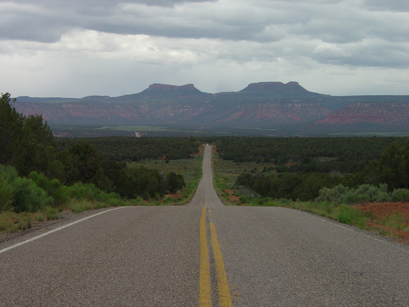 Bears EarsSummit · ~3 min drivePhoto: U.S. Geological Surey, Public domain (via Wikimedia Commons)
- Grand Gulch overflow campgroundCamping · ~5 min drive
 Arch CanyonRock climbing · ~12 min drivePhoto: BLMUtah, Public domain (via Wikimedia Commons)
Best time to visit Bears Ears Loop
Best months: April–June and August–October. Best months have typical highs of 55–85 °F, lows of 30 °F or warmer (32 °F where the station doesn't record snow), at most one snowy day and no more than 12 wet days.
Jan
39° / 20°
6 wet · 4 snow
Feb
43° / 24°
6 wet · 3 snow
Mar
53° / 30°
5 wet · 2 snow
Apr
60° / 35°
5 wet · 1 snow
May
71° / 44°
5 wet
Jun
83° / 54°
3 wet
Jul
89° / 60°
7 wet
Aug
85° / 58°
8 wet
Sep
77° / 51°
6 wet
Oct
63° / 39°
5 wet
Nov
50° / 29°
4 wet · 2 snow
Dec
39° / 20°
6 wet · 4 snow
Typical high / low (°F) and days with rain or snow, 1991–2020. Measured at Natural Bridges Nm, UT, 5.3 mi away at 6,508 ft. The station sits about 1,600 ft lower than this place, so expect it a little cooler here. Source: NOAA NCEI U.S. Climate Normals 1991–2020.
