Bears Ears
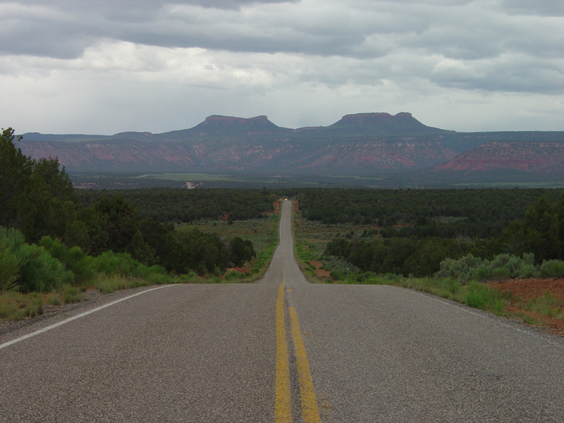 Photo: U.S. Geological Surey, Public domain (via Wikimedia Commons)
- 9,061 ft
- summit
- Forest Service
- managed by
Is Bears Ears open right now?
Alert in the area
The Forest Service lists an alert for Monticello Ranger District.
Hazardous Road Conditions – Moab Monticello Ranger Districts 11.4.2026
Agency alert covering Monticello Ranger District · USFS · Monticello Ranger District
As of · Source: USFS · Monticello Ranger District. Agencies don't list every closure — check before you go.
Bears Ears is a summit in San Juan County, Utah, on the Monticello Ranger District of the Manti-La Sal National Forest. The Forest Service manages the land, and the nearest town is Blanding, about 19 miles away. The peak sits within a cluster of trails and rides, so it can anchor a broader day on the district rather than serve as a single destination. Several routes start close by. Lyman Canyon Overlook is under a mile away, and Short Point Trail is about a mile off. Mountain bikers can pick up the Bears Ears Loop roughly 1.5 miles from the summit, and the Arch Canyon Overlook Trail lies about 2.7 miles away.
Conditions and forecast
Daily highs and lows, wind and the chance of precipitation at the summit for the next 7 days, from the Open-Meteo model.
- Summit elevation
- 9,061 ft
- Land manager
- Forest Service
Elevation from USGS 3D Elevation Program terrain data (about 10 m resolution).
We don't know of a mapped trail or route to the summit of Bears Ears. Plan the approach with local maps, a guidebook or a local guide, and check conditions before you go.
Questions about Bears Ears
How tall is Bears Ears?
9,061 ft (2,762 m).
Is there a trail to the top of Bears Ears?
We don't know of a mapped trail or route to the summit. Plan the approach with local maps, a guidebook or a local guide.
- Salvation Knoll7,241 ft · Utah1 route4.8 mi away
- Mulley Point6,316 ft · Utah1 route28 mi away
 Aztec Butte6,310 ft · Utah1 route53 mi awayPhoto: G. Edward Johnson, CC BY 4.0 (via Wikimedia Commons)
 Upheaval Dome5,927 ft · Utah1 route55 mi awayPhoto: Jim Stuby (user Jstuby), Public domain (via Wikimedia Commons)
- Dead Horse Point6,022 ft · Utah1 route59 mi away
 Mount Tukuhnikivatz12,480 ft · Utah1 route65 mi awayPhoto: Erik Wilde, CC BY-SA 2.0 (via Wikimedia Commons)
- Lyman Canyon OverlookHiking0.7 mi
- Short Point TrailHiking1.1 mi
 Bears Ears LoopMountain bikingPhoto: brewbooks from near Seattle, USA, CC BY-SA 2.0 (via Wikimedia Commons)1.5 mi
- Woodenshoe RoadHiking1.5 mi
- West Rim Texas CanyonMountain biking2 mi
- East Texas RimHiking2 mi
- Arch Canyon Overlook TrailHiking2.7 mi
- Peavine CanyonHiking3 mi
Source: Roamze catalog (indexable pages within 10 miles, PostGIS distance)
 Pinenut KnollSummit · ~35 min drivePhoto: Steven Baltakatei Sandoval, CC BY-SA 4.0 (via Wikimedia Commons)
 Castle ButteSummit · ~37 min drivePhoto: The Greater Southwestern Exploration Company from Claremont, California, United States, CC BY 2.0 (via Wikimedia Commons)
 Rooster ButteSummit · ~42 min drivePhoto: mark byzewski, CC BY 2.0 (via Wikimedia Commons)
 Setting Hen ButteSummit · ~42 min drivePhoto: The Greater Southwestern Exploration Company from Claremont, California, United States, CC BY 2.0 (via Wikimedia Commons)
 SugarloafSummit · ~49 min drivePhoto: Famartin, CC BY-SA 3.0 (via Wikimedia Commons)
 South Sixshooter PeakSummit · ~1h 1m drivePhoto: dfbphotos, CC BY 2.0 (via Wikimedia Commons)
 North Sixshooter PeakSummit · ~1h 3m drivePhoto: Bureau of Land Management, CC BY 2.0 (via Wikimedia Commons)
 Mount HolmesSummit · ~1h 11m drivePhoto: Murray Foubister, CC BY-SA 2.0 (via Wikimedia Commons)
 Brighams TombSummit · ~1h 12m drivePhoto: MARELBU, CC BY 3.0 (via Wikimedia Commons)
 Setting HenSummit · ~1h 12m drivePhoto: Frank Kovalchek from Anchorage, Alaska, USA, CC BY 2.0 (via Wikimedia Commons)
Also worth it near here
 Lyman Canyon OverlookMountain biking · ~2 min drivePhoto: brewbooks from near Seattle, USA, CC BY-SA 2.0 (via Wikimedia Commons)
 Texas TrailHiking · ~6 min drivePhoto: Ken Lund from Reno, Nevada, USA, CC BY-SA 2.0 (via Wikimedia Commons)
- Grand Gulch overflow campgroundCamping · ~7 min drive
 Arch CanyonRock climbing · ~10 min drivePhoto: BLMUtah, Public domain (via Wikimedia Commons)
