Wesser Bald
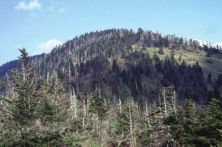
 Photo: Chuck Williams, CC BY 3.0 (via Wikimedia Commons)
- 4,625 ft
- summit
Is Wesser Bald open right now?
Closure in the area
There's a closure order in National Forests in North Carolina. It doesn't name Wesser Bald, so check the source for the area it covers (3 listed).
Maple Sally Road Closure
Agency closure covering National Forests in North Carolina · USFS · National Forests in North Carolina
Table Rock Road construction starts Nov. 2, 2026
Agency closure covering National Forests in North Carolina · USFS · National Forests in North Carolina
List of trail closures post-Hurricane Helene
Park closure covering Appalachian National Scenic Trail · NPS · Appalachian National Scenic Trail
Temporary Closure - The Elk Falls Trail
Agency alert covering National Forests in North Carolina · USFS · National Forests in North Carolina
Rainbow Springs Road closed for reconstruction
Agency alert covering National Forests in North Carolina · USFS · National Forests in North Carolina
As of · Source: USFS · National Forests in North Carolina. Agencies don't list every closure — check before you go.
Wesser Bald is a summit of about 4,625 feet in Macon County, North Carolina, within the Nantahala Ranger District of the National Forests in North Carolina. It lies along the Appalachian National Scenic Trail, and the nearest town is Bryson City, about 13 miles away. Wesser Creek is the closest neighbor, about 2 miles away. The Nantahala River offers fishing about 5 miles off, and the Nantahala River Bike Trail is a little farther. For an overnight base, Tsali Campground sits about 9 miles away.
Conditions and forecast
Daily highs and lows, wind and the chance of precipitation at the summit for the next 7 days, from the Open-Meteo model.
- Summit elevation
- 4,625 ft
Elevation from USGS 3D Elevation Program terrain data (about 10 m resolution).
We don't know of a mapped trail or route to the summit of Wesser Bald. Plan the approach with local maps, a guidebook or a local guide, and check conditions before you go.
Questions about Wesser Bald
How tall is Wesser Bald?
4,625 ft (1,410 m).
Is there a trail to the top of Wesser Bald?
We don't know of a mapped trail or route to the summit. Plan the approach with local maps, a guidebook or a local guide.
- Goat Bald4,913 ft · North Carolina1 route6.9 mi away
- Piercy Bald4,440 ft · North Carolina1 route7.1 mi away
- Teyahalee Bald4,716 ft · North Carolina1 route12 mi away
- Signal Bald5,279 ft · North Carolina1 route12 mi away
- Tusquitee Bald5,266 ft · North Carolina1 route13 mi away
- Sassafras Knob4,678 ft · North Carolina2 routes13 mi away
- Wesser CreekHiking1.9 mi
- Nantahala RiverRiver fishing4.7 mi
 Nantahala River Bike TrailHikingPhoto: gary_leavens, CC BY-SA 2.0 (via Wikimedia Commons)5.7 mi
- AppletreeHiking5.8 mi
- Nantahala National ForestRiver fishing6.6 mi
- Tsali CampgroundCamping9 mi
- Nantahala Lake Dispersed Camping Site - Lake AccesCamping9.1 mi
- Fontana LakeLake fishing9.1 mi
Source: Roamze catalog (indexable pages within 10 miles, PostGIS distance)
 Albert MountainSummit · ~28 min drivePhoto: Thomson200, CC0 (via Wikimedia Commons)
 KuwohiSummit · ~35 min drivePhoto: C. Kenneth Dodd, Jr., Public domain (via Wikimedia Commons)
 Dicks KnobSummit · ~35 min drivePhoto: Thomson200, CC0 (via Wikimedia Commons)
 Thunderhead MountainSummit · ~37 min drivePhoto: Notneb82, CC BY-SA 3.0 (via Wikimedia Commons)
- Goat BaldSummit · ~12 min drive
- Little BaldSummit · ~19 min drive
- Teyahalee BaldSummit · ~21 min drive
- Weatherman BaldSummit · ~21 min drive
- Tusquitee BaldSummit · ~22 min drive
- Sassafras KnobSummit · ~22 min drive
Also worth it near here
- Nantahala River, Silver Mine Take-Out #3 Boating SiteBoat launch · ~7 min drive
- Queens FallsWaterfall · ~8 min drive
- Nantahala RiverRiver fishing · ~8 min drive
- Nantahala River Bike TrailMountain biking · ~10 min drive
 A.T. Wayah Bald ShelterCamping · ~10 min drivePhoto: Juggar, CC BY-SA 4.0 (via Wikimedia Commons)
