Fahnestock Group Campsite 1 and 2
Campground
Campground · 6.0 mi from the trail
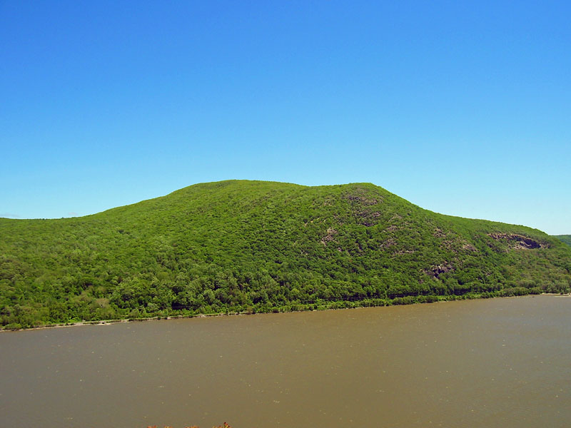
 Photo: Daniel Case, CC BY-SA 3.0 (via Wikimedia Commons)
Sugarloaf Mountain is a summit in Dutchess County, New York, rising to about 882 feet. The nearest town is Nelsonville, about 2.4 miles away. Late spring and early fall tend to be the most comfortable times to go. Typical averages from the nearby West Point weather station show highs around 72°F in May and 76°F in September, and temperatures on the summit run cooler than those figures. Summer is warmer, with July highs averaging about 85°F. Several trails start close by. The Breakneck Bypass Trail (Red) is about 0.4 miles away, and the Cornish Trail, Notch Trail (Blue) and Undercliff Trail are all within a mile. Storm King Mountain, a climbing area about 2.1 miles off, adds more to the mix.
Fahnestock Group Campsite 1 and 2
Campground
 If it rainsThe original uploader was Daniel Case at English Wikipedia ., CC BY-SA 3.0 · Wikimedia Commons
Places © OpenStreetMap contributors · Photos: The original uploader was Daniel Case at English Wikipedia ., CC BY-SA 3.0 (commons)
More in New WindsorDaily highs and lows, wind and the chance of precipitation at the summit for the next 7 days, from the Open-Meteo model.
Elevation from USGS 3D Elevation Program terrain data (about 10 m resolution).
We don't know of a mapped trail or route to the summit of Sugarloaf Mountain. Plan the approach with local maps, a guidebook or a local guide, and check conditions before you go.
882 ft (269 m).
We don't know of a mapped trail or route to the summit. Plan the approach with local maps, a guidebook or a local guide.

 Breakneck Bypass Trail (Red)HikingPhoto: alecperkins, CC BY 2.0 (via Flickr)0.4 mi
 Cornish TrailHikingPhoto: New York Public Library, No restrictions (via Wikimedia Commons)0.7 mi
 Notch Trail (Blue)HikingPhoto: alecperkins, CC BY 2.0 (via Flickr)0.8 mi
 Undercliff TrailHikingPhoto: Jeffrey Pang from Berkeley, CA, USA, CC BY 2.0 (via Wikimedia Commons)0.9 miBreakneck Ridge Trail (White)HikingPhoto: Jeffrey Pang from Berkeley, CA, USA, CC BY 2.0 (via Wikimedia Commons)1.1 miNimham TrailHikingPhoto: Jeffrey Pang from Berkeley, CA, USA, CC BY 2.0 (via Wikimedia Commons)1.1 mi
 Storm King MountainRock climbingPhoto: Steven-L-Johnson, CC BY 2.0 (via Flickr)2.1 mi
 Moodna CreekCanoeingPhoto: Daniel Case, CC BY-SA 3.0 (via Wikimedia Commons)7.2 mi
Source: Roamze catalog (indexable pages within 10 miles, PostGIS distance)
Bull HillSummit · ~3 min drivePhoto: Daniel Case, CC BY-SA 3.0 (via Wikimedia Commons)Storm King MountainSummit · ~4 min drivePhoto: The original uploader was Daniel Case at English Wikipedia., CC BY-SA 3.0 (via Wikimedia Commons) Crows NestSummit · ~6 min drivePhoto: Ahodges7, CC BY-SA 3.0 (via Wikimedia Commons)
 Sugarloaf HillSummit · ~12 min drivePhoto: Juliancolton, CC0 (via Wikimedia Commons)
 Schunnemunk MountainSummit · ~17 min drivePhoto: The original uploader was Daniel Case at English Wikipedia., CC BY-SA 3.0 (via Wikimedia Commons)
 Bear MountainSummit · ~17 min drivePhoto: The original uploader was Daniel Case at English Wikipedia., CC BY-SA 3.0 (via Wikimedia Commons)
Best months: April–October. Best months have typical highs of 55–85 °F, lows of 30 °F or warmer (32 °F where the station doesn't record snow), at most one snowy day and no more than 12 wet days.
Jan
36° / 21°
10 wet · 3 snow
Feb
39° / 22°
8 wet · 3 snow
Mar
47° / 30°
10 wet · 2 snow
Apr
60° / 41°
10 wet
May
72° / 51°
12 wet
Jun
80° / 60°
11 wet
Jul
85° / 65°
10 wet
Aug
83° / 64°
9 wet
Sep
76° / 57°
8 wet
Oct
63° / 46°
10 wet
Nov
51° / 36°
9 wet
Dec
41° / 27°
10 wet · 2 snow
Typical high / low (°F) and days with rain or snow, 1991–2020. Measured at West Point, NY, 4.7 mi away at 320 ft. The station sits about 600 ft lower than this place, so expect it a little cooler here. Source: NOAA NCEI U.S. Climate Normals 1991–2020.
