Slick Rock
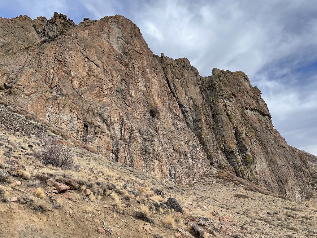 Photo: Seth Tisue, CC BY-SA 2.0 (via Flickr)
- 6.9 mi
- round trip
- 758 ft
- climb
- 8,549 ft
- high point
- Out and back
- route
Is Slick Rock open right now?
Closure in the area
There's a closure order in Humboldt-Toiyabe National Forest. It doesn't name Slick Rock, so check the source for the area it covers.
Elephant Fire Closure
Agency closure covering Humboldt-Toiyabe National Forest · Order 04-17-26-01-04 · USFS · Humboldt-Toiyabe National Forest
Area, Road, and Trail Closures (Spring Mountains National Recreation Area)
Agency alert covering Humboldt-Toiyabe National Forest · Order 04-17-25-04 · USFS · Humboldt-Toiyabe National Forest
Year-Round Fire Restrictions (Spring Mountains National Recreation Area)
Agency alert covering Humboldt-Toiyabe National Forest · Order 04-17-24-01 · USFS · Humboldt-Toiyabe National Forest
Vehicle Snow Chain Requirements during Inclement Weather (Spring Mountains National Recreation Area)
Agency alert covering Humboldt-Toiyabe National Forest · Order 04-17-23-01 · USFS · Humboldt-Toiyabe National Forest
Rainbow Canyon Flood Diversion Structure Closure (Spring Mountains National Recreation Area)
Agency alert covering Humboldt-Toiyabe National Forest · Order 04-17-15-01 · USFS · Humboldt-Toiyabe National Forest
As of · Source: USFS · Humboldt-Toiyabe National Forest. Agencies don't list every closure — check before you go.
Slick Rock is a hard hike in the Santa Rosa Ranger District of Humboldt-Toiyabe National Forest in Nevada, about 6.9 miles long with a one-way elevation gain of 758 feet. The trail is an out-and-back, starting at a low point of about 7,494 feet and reaching a high of about 8,549 feet. The trail is natural-surface and allows bikes, and it is not an accessible route. The Forest Service manages the land. Paradise Valley, a climbing area, sits about 0.6 miles away, and Lye Creek Campground is about 1.4 miles off. The Slick Rock Trail and the Deep Creek to Box Canyon hike are also within a few miles.
Keep exploring — more trails worth the drive
 Photo: Matt Lavin, CC BY-SA 2.0 (via Flickr)
Pole Line Trail
~1h 21m drive
1.64-mile out-and-back trail in Nevada with 1,711 ft elevation gain
 Photo: Matt Lavin, CC BY-SA 2.0 (via Flickr)
Lower Loop
~1h 22m drive
3.26-mile loop in Nevada with 586 ft elevation gain/loss.
HIKE
Deep Creek to Box Canyon
~6 min drive
11.57-mile out-and-back trail from Deep Creek to Box Canyon in Nevada.
HIKE
Single Tree Trail
~9 min drive
15.12-mile out-and-back hike in Nevada with 3,809 ft elevation gain and loss.
HIKE
Slick Rock Trail
~3 min drive
1.76-mile out-and-back hike in Nevada with 1,322 ft elevation gain
 Photo: Ken Lund, CC BY-SA 2.0 (via Flickr)
Ditch Trail
~1h 24m drive
1.88-mile out-and-back trail in Nevada with 135 ft elevation gain
HIKE
Summit Trail
~14 min drive
13.66-mile out-and-back hike in Nevada with 932 ft gain.
HIKE
Summit Trail
~24 min drive
Expert 16.81-mile Nevada summit route with substantial elevation gain.
HIKE
Little Cottonwood Creek
~18 min drive
3.31-mile out-and-back trail in Nevada with 764 ft gain.
 Photo: Doug Letterman, CC BY 2.0 (via Flickr)
Water Canyon-Bloody Shins Connector
~1h 25m drive
1.54-mile out-and-back trail in Nevada with 223 ft elevation gain/loss.


Route details
- Distance
- 6.9 mi round trip
- Climbing
- About 758 ft
- Summit
- 8,533 ft
- Difficulty
- Hard
- Time
- About 2.5 hours
Season
Season: Year-round.
Questions about this route
How long is the Slick Rock on Hinkey Summit?
About 6.9 mi round trip.
How much elevation gain is on the Slick Rock?
About 758 ft of climbing round trip.
How hard is the Slick Rock?
It is rated hard.
How long does the Slick Rock take?
About 2.5 hours round trip.
When is the best time for the Slick Rock?
Year-round.
Conditions and forecast on Hinkey Summit
Daily highs and lows, wind and the chance of precipitation at the summit and route start for the next 7 days, from the Open-Meteo model.
