Buckhorn Creek
- 6.4 mi
- distance
- 5,119 ft
- high point
- May–Jun, Sep
- best months
Is Buckhorn Creek open right now?
Alert in the area
The Forest Service lists 5 alerts for Payette National Forest.
Over Snow Vehicle Closure (Forestwide)
Agency alert covering Payette National Forest · Order 0412-638 · USFS · Payette National Forest
Over Snow Vehicle Closure (Brundage Mountain Resort Snowcat Routes)
Agency alert covering Payette National Forest · Order 0412-637 · USFS · Payette National Forest
Lost Valley Log Hauling
Agency alert covering Payette National Forest · USFS · Payette National Forest
Over Snow Vehicle Closure (Granite Mountain)
Agency alert covering Payette National Forest · Order 0412-635 · USFS · Payette National Forest
Gordon Titus Upper Elevation Parking Lot Winter Restrictions
Agency alert covering Payette National Forest · Order 0412-543 · USFS · Payette National Forest
As of · Source: USFS · Payette National Forest. Agencies don't list every closure — check before you go.
Buckhorn Creek is a canoeing route in Idaho's Payette National Forest, within the Krassel Ranger District and managed by the Forest Service. It sits about 6 miles from the district's center, and the nearest town is Yellowpine, which makes it an easy pairing with other outings in this part of the forest. Summer is the most comfortable time to canoe here. Typical averages from the nearby Yellowpine weather station run from highs near 74°F in June to about 87°F in July and August, with fewer wet days in late summer than the rest of the year. Winters are cold, with January highs around 36°F and lows near 12°F. Several other trails lie close by. The Buckhorn Creek Cut-Off is about 1.5 miles away, and the West Fork Buckhorn and South Fork Buckhorn Creek hikes are both within roughly 2 miles. For an overnight base, Phoebe Creek campground is about 3 miles off.
Local outfitters
- Black Bear RV Park15 mi away
- Arrowhead RV Park30 mi away
Not on Roamze yet. Their page has how to reach them.
- BUCKHORN CREEK CUT-OFFHiking1.5 mi
- West Fork BuckhornHiking2.2 mi
- South Fork Buckhorn CreekHiking2.3 mi
- Phoebe CreekCamping3.3 mi
- Reed Ranch Airstrip Developed SiteCamping3.6 mi
- Camp CreekCamping3.8 mi
- Baby ProblemsRock climbing9.2 mi
- Jug Handle BoulderingRock climbing9.5 mi
Source: Roamze catalog (indexable pages within 10 miles, PostGIS distance)
 North Fork Payette RiverCanoeing · ~30 min drivePhoto: Mll1013, Public domain (via Wikimedia Commons)
- Shoreline Boating SiteBoat launch · ~31 min drive
- Island Bar Recreation SiteFloat trip · ~1h 13m drive
 Little Salmon RiverCanoeing · ~46 min drivePhoto: NOAA, Public domain (via Wikimedia Commons)
- Upper Payette Lake Boat RampBoat launch · ~33 min drive
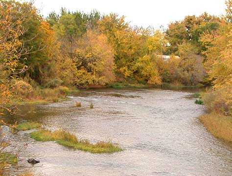 Weiser RiverCanoeing · ~52 min drivePhoto: Decumanus, CC BY-SA 3.0 (via Wikimedia Commons)
- Rainbow PointBoat launch · ~38 min drive
 Middle Fork Salmon RiverCanoeing · ~59 min drivePhoto: Rex Parker, CC BY 2.0 (via Wikimedia Commons)
- ButtercupBoat launch · ~38 min drive
 South Fork Salmon RiverCanoeing · ~26 min drivePhoto: Zachary Collier, CC BY 2.0 (via Wikimedia Commons)
Best time to visit Buckhorn Creek
Best months: May–June and September. Best months have typical highs of 55–85 °F, lows of 30 °F or warmer (32 °F where the station doesn't record snow), at most one snowy day and no more than 12 wet days.
Jan
36° / 12°
13 wet
Feb
40° / 16°
13 wet
Mar
46° / 23°
14 wet
Apr
56° / 29°
12 wet
May
64° / 35°
12 wet
Jun
74° / 41°
10 wet
Jul
87° / 45°
6 wet
Aug
87° / 45°
5 wet
Sep
76° / 37°
8 wet
Oct
59° / 30°
11 wet
Nov
43° / 22°
12 wet
Dec
34° / 15°
14 wet
Typical high / low (°F) and days with rain or snow, 1991–2020. Measured at Yellowpine, ID, 14.6 mi away at 5,050 ft. This station doesn't record snowfall. Source: NOAA NCEI U.S. Climate Normals 1991–2020.
Closures we've recorded since August 2026
Over Snow Vehicle Closure (Forestwide)
Payette National Forest · Order dated November 2, 2026; seen Nov 10, 2026, no lift recorded · Forest Service

