Weiser River
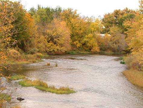 Photo: Decumanus, CC BY-SA 3.0 (via Wikimedia Commons)
- 23.0 mi
- distance
- 4,175 ft
- high point
- May–Sep
- best months
Is Weiser River open right now?
Alert in the area
The Forest Service lists 5 alerts for Payette National Forest.
Over Snow Vehicle Closure (Forestwide)
Agency alert covering Payette National Forest · Order 0412-638 · USFS · Payette National Forest
Over Snow Vehicle Closure (Brundage Mountain Resort Snowcat Routes)
Agency alert covering Payette National Forest · Order 0412-637 · USFS · Payette National Forest
Lost Valley Log Hauling
Agency alert covering Payette National Forest · USFS · Payette National Forest
Over Snow Vehicle Closure (Granite Mountain)
Agency alert covering Payette National Forest · Order 0412-635 · USFS · Payette National Forest
Gordon Titus Upper Elevation Parking Lot Winter Restrictions
Agency alert covering Payette National Forest · Order 0412-543 · USFS · Payette National Forest
As of · Source: USFS · Payette National Forest. Agencies don't list every closure — check before you go.
The Weiser River is a canoeing route in Idaho's Payette National Forest, within the New Meadows Ranger District. The Forest Service manages the surrounding land, and paddlers will find two campgrounds close at hand: Evergreen Campground is about 2 miles away and Cold Spring about 3 miles away, both good bases for a trip on the water. Summer is the most comfortable season to paddle. Typical averages from a nearby weather station show July and August highs around 85°F with lows in the low 40s, while winter highs stay near or below freezing. The West Fork Weiser River, about 5 miles away, offers another canoeing option, and the West River Recreational Trail is a hike roughly 6 miles off. Paddlers looking for more water can also head to the Little Salmon River, about 10 miles away.
Local outfitters
- Black Bear RV Park15 mi away
- Arrowhead RV Park33 mi away
Not on Roamze yet. Their page has how to reach them.
 Evergreen CampgroundCampingPhoto: Recreation.gov (RIDB) / public domain1.9 mi
- Cold SpringCamping2.8 mi
- West Fork Weiser RiverCanoeing4.6 mi
- West River Recreational TrailHiking5.9 mi
- East Branch Goose CreekCanoeing8.5 mi
 Little Salmon RiverCanoeingPhoto: NOAA, Public domain (via Wikimedia Commons)9.8 mi
Source: Roamze catalog (indexable pages within 10 miles, PostGIS distance)
- Little Salmon RiverCanoeing · ~17 min drivePhoto: NOAA, Public domain (via Wikimedia Commons)
- ButtercupBoat launch · ~37 min drive
- Island Bar Recreation SiteFloat trip · ~1h drive
 Imnaha RiverCanoeing · ~54 min drivePhoto: Sam Beebe, CC BY 2.0 (via Wikimedia Commons)
- Copper Creek Boat LaunchBoat launch · ~37 min drive
 North Fork Payette RiverCanoeing · ~35 min drivePhoto: Mll1013, Public domain (via Wikimedia Commons)
- Poison Creek CampgroundBoat launch · ~38 min drive
- West Fork Weiser RiverCanoeing · ~8 min drive
- Bob Creek Boat LaunchBoat launch · ~39 min drive
- East Branch Goose CreekCanoeing · ~15 min drive
Best time to visit Weiser River
Best months: May–September. Best months have typical highs of 55–85 °F, lows of 30 °F or warmer (32 °F where the station doesn't record snow), at most one snowy day and no more than 12 wet days.
Jan
30° / 9°
Feb
36° / 12°
Mar
45° / 21°
Apr
55° / 27°
May
64° / 33°
Jun
72° / 39°
Jul
85° / 43°
Aug
85° / 41°
Sep
75° / 33°
Oct
59° / 25°
Nov
42° / 19°
Dec
31° / 13°
Typical high / low (°F) and days with rain or snow, 1991–2020. Measured at New Meadows Rs, ID, 6.6 mi away at 3,862 ft. This station doesn't record snowfall. Source: NOAA NCEI U.S. Climate Normals 1991–2020.
Closures we've recorded since August 2026
Over Snow Vehicle Closure (Forestwide)
Payette National Forest · Order dated November 2, 2026; seen Nov 10, 2026, no lift recorded · Forest Service
