Rio Grande Pyramid
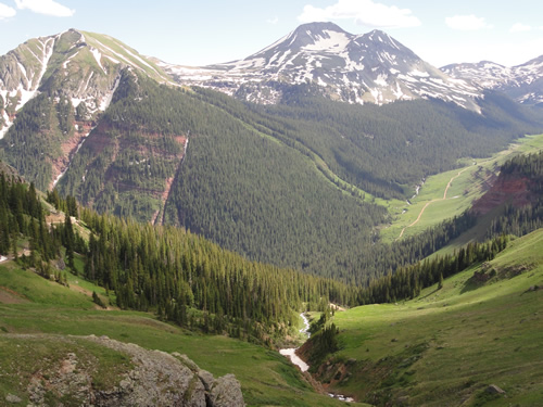 Photo: U.S. Forest Service Staff, Public domain (via Wikimedia Commons)
- 13,820 ft
- summit
- 1
- way up
- Forest Service
- managed by
Is Rio Grande Pyramid open right now?
Closure in the area
There's a closure order in Rio Grande National Forest. It doesn't name Rio Grande Pyramid, so check the source for the area it covers.
Closures and dangerous conditions on roads, bridges, and trails from flooding
Agency closure covering Rio Grande National Forest · USFS · Rio Grande National Forest
As of · Source: USFS · Rio Grande National Forest. Agencies don't list every closure — check before you go.
Rio Grande Pyramid is a summit in Hinsdale County, Colorado, rising inside the Weminuche Wilderness on the Rio Grande National Forest. It falls within the Divide Ranger District and is managed by the Forest Service. The nearest town is Howardsville, about 15 miles away. A summit route leads to the top, making this a destination for those looking to stand on a high peak deep in wilderness country rather than a roadside stop. Because the peak lies within a designated wilderness, plan for a backcountry trip and follow the rules that govern wilderness travel on Forest Service land. Getting to the mountain means traveling through the Weminuche, so a visit here is an outing into remote terrain rather than a quick hike from a parking area. Close by are the East Ute and West Ute hikes, about 2 miles off, and Ute Creek, a paddling spot roughly 3.4 miles away. Lost Trail Campground, about 6.6 miles away, offers a place to camp in the area.
Conditions and forecast
Daily highs and lows, wind and the chance of precipitation at the summit and thirty mile trailhead for the next 7 days, from the Open-Meteo model.
- Summit elevation
- 13,820 ft
- Land manager
- Forest Service
Elevation from USGS 3D Elevation Program terrain data (about 10 m resolution).
Map © Mapbox © OpenStreetMap contributors Questions about Rio Grande Pyramid
How tall is Rio Grande Pyramid?
13,820 ft (4,212 m).
How many routes go to the summit of Rio Grande Pyramid?
One: Rio Grande Pyramid.
Where do the routes up Rio Grande Pyramid start?
Rio Grande Pyramid starts at Thirty Mile Trailhead.
- East UteHiking1.9 mi
- West UteHiking2.2 mi
- Ute CreekCanoeing3.4 mi
 Los Pinos RiverCanoeingPhoto: Jeffrey Beall, CC BY 4.0 (via Wikimedia Commons)5.5 mi
- Lost Trail CampgroundCamping6.6 mi
- Jagged MountainMountaineering7.2 mi
- The Pope's NoseRock climbing7.6 mi
- Thirty MileCamping8 mi
Source: Roamze catalog (indexable pages within 10 miles, PostGIS distance)
 Irving PeakSummit · ~15 min drivePhoto: Jeremiah LaRocco, CC BY-SA 2.0 (via Wikimedia Commons)
 Greenhalgh MountainSummit · ~16 min drivePhoto: Bruno Rijsman, CC BY-SA 2.0 (via Wikimedia Commons)
 Thunder MountainSummit · ~18 min drivePhoto: Jeremiah LaRocco, CC BY-SA 2.0 (via Wikimedia Commons)
 Vestal PeakSummit · ~20 min drivePhoto: Doug Lynne, CC BY-SA 2.0 (via Wikimedia Commons)
 Cimarrona PeakSummit · ~20 min drivePhoto: Jeffrey Beall, CC BY 4.0 (via Wikimedia Commons)
 Windom PeakSummit · ~20 min drivePhoto: Jeremiah LaRocco, CC BY-SA 2.0 (via Wikimedia Commons)
 Sunlight PeakSummit · ~20 min drivePhoto: Evil.Satellite at English Wikipedia, Public domain (via Wikimedia Commons)
 Organ MountainSummit · ~20 min drivePhoto: Jeremiah LaRocco, CC BY-SA 2.0 (via Wikimedia Commons)
 Canby MountainSummit · ~20 min drivePhoto: Bruno Rijsman, CC BY-SA 2.0 (via Wikimedia Commons)
 Jupiter MountainSummit · ~20 min drivePhoto: Jeremiah LaRocco, CC BY-SA 2.0 (via Wikimedia Commons)
Also worth it near here
 Ute LakeHiking · ~5 min drivePhoto: dsearls, CC BY 2.0 (via Flickr)
- Los Pinos RiverCanoeing · ~9 min drivePhoto: Jeffrey Beall, CC BY 4.0 (via Wikimedia Commons)
- Divide LakesLake fishing · ~11 min drive
- Rio Grande Reservoir Boating SiteBoat launch · ~11 min drive
- Pine RiverMountain biking · ~12 min drive
