Pleasants Peak
 Photo: Northwalker, CC0 (via Wikimedia Commons)
- 4,004 ft
- summit
- Forest Service
- managed by
Is Pleasants Peak open right now?
Closure in the area
There's a closure order in Cleveland National Forest. It doesn't name Pleasants Peak, so check the source for the area it covers.
Airport Fire Burned Area Closure
Agency closure covering Cleveland National Forest · Order 02-26-09 · USFS · Cleveland National Forest
Cedar Creek Falls Visitor Use Permit Area
Agency alert covering Cleveland National Forest · Order 02-26-07 · USFS · Cleveland National Forest
Cedar Creek Falls Cliff Closure Area
Agency alert covering Cleveland National Forest · Order 02-26-06 · USFS · Cleveland National Forest
Cedar Creek Falls Alcohol Prohibition
Agency alert covering Cleveland National Forest · USFS · Cleveland National Forest
As of · Source: USFS · Cleveland National Forest. Agencies don't list every closure — check before you go.
Pleasants Peak is a summit of about 4,004 feet in Riverside County, California, within the Trabuco Ranger District of Cleveland National Forest. The nearest town is Silverado, about 3.6 miles away, and the Forest Service manages the surrounding land. The closest trail is Smashmouth Trail, just 0.2 miles away. Ladd Canyon and Skinsuit Trail lie within about a mile and a half, and Black Star Canyon Bouldering is about 3.2 miles off for anyone who wants to climb.
Conditions and forecast
Daily highs and lows, wind and the chance of precipitation at the summit for the next 7 days, from the Open-Meteo model.
- Summit elevation
- 4,004 ft
- Land manager
- Forest Service
Elevation from USGS 3D Elevation Program terrain data (about 10 m resolution).
We don't know of a mapped trail or route to the summit of Pleasants Peak. Plan the approach with local maps, a guidebook or a local guide, and check conditions before you go.
Questions about Pleasants Peak
How tall is Pleasants Peak?
4,004 ft (1,220 m).
Is there a trail to the top of Pleasants Peak?
We don't know of a mapped trail or route to the summit. Plan the approach with local maps, a guidebook or a local guide.
- Robbers Peak1,130 ft · California1 route8.9 mi away
- San Juan Hill1,780 ft · California2 routes11 mi away
 Los Pinos Peak4,510 ft · California2 routes12 mi awayPhoto: Shannon1, CC BY-SA 4.0 (via Wikimedia Commons)
- Gilman Peak1,681 ft · California2 routes13 mi away
- Sugarloaf3,320 ft · California1 route13 mi away
 Mount Jurupa2,221 ft · California1 route19 mi awayPhoto: Scottthezombie, CC BY-SA 4.0 (via Wikimedia Commons)
- Smashmouth TrailHiking0.2 mi
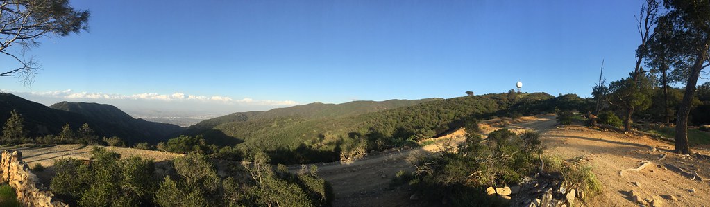
 Ladd CanyonHikingPhoto: Northwalker, CC0 (via Wikimedia Commons)1.3 mi
 Skinsuit TrailHikingPhoto: bensondoc, CC BY-SA 2.0 (via Flickr)1.6 mi
 Troy Lee TrailHikingPhoto: sergei.gussev, CC BY 2.0 (via Flickr)2.9 mi
- Black Star Canyon BoulderingRock climbing3.2 mi
 Silverado Motor WayHikingPhoto: Steve Riggins, CC BY 3.0 (via Wikimedia Commons)3.5 mi
- Silverado Truck TrailHiking4.3 mi
- Batman BoulderRock climbing9.1 mi
Source: Roamze catalog (indexable pages within 10 miles, PostGIS distance)
 Flores PeakSummit · ~10 min drivePhoto: Uncabunca, CC BY-SA 4.0 (via Wikimedia Commons)
 Modjeska PeakSummit · ~11 min drivePhoto: Justin Johnsen (Justin.Johnsen), CC BY-SA 3.0 (via Wikimedia Commons)
 Santiago PeakSummit · ~12 min drivePhoto: Nandaro, CC BY-SA 3.0 (via Wikimedia Commons)
 Trabuco PeakSummit · ~17 min drivePhoto: Don Ramey Logan, CC BY-SA 4.0 (via Wikimedia Commons)
- Los Pinos PeakSummit · ~20 min drivePhoto: Shannon1, CC BY-SA 4.0 (via Wikimedia Commons)
 Mount RubidouxSummit · ~31 min drivePhoto: No machine-readable author provided. Takwish assumed (based on copyright claims)., CC BY-SA 2.5 (via Wikimedia Commons)
- Mount JurupaSummit · ~32 min drivePhoto: Scottthezombie, CC BY-SA 4.0 (via Wikimedia Commons)
 Rome HillSummit · ~34 min drivePhoto: Z3lvs, CC0 (via Wikimedia Commons)
 Slover MountainSummit · ~41 min drivePhoto: Unknown authorUnknown author, Public domain (via Wikimedia Commons)
 Redonda MesaSummit · ~44 min drivePhoto: Temeku at English Wikipedia, CC0 (via Wikimedia Commons)
