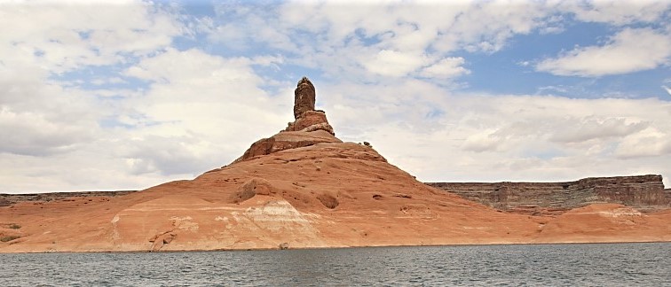
Tower Butte
 Photo: mark byzewski, CC BY 2.0 (via Wikimedia Commons)
- 5,286 ft
- summit
- Mar–May, Oct–Nov
- best months
Tower Butte is a summit in northern Arizona, rising to 5,286 feet within the Navajo Region Fire and Aviation Management area. The nearest town is LeChee, about 10 miles away. Spring and fall are the most comfortable times to visit. Typical averages from a nearby weather station at Page, which sits roughly 1,000 feet lower, show April and October highs around 72°F with lows in the upper 40s. That station's July highs average 98°F, and temperatures on the butte run cooler. Several trails lie within about 9 miles, including Alstrom Point Trail, Owl Canyon Trail and the Rim Trail. Anchovy Point, a climbing area, is about 10 miles away.
Conditions and forecast
Daily highs and lows, wind and the chance of precipitation at the summit for the next 7 days, from the Open-Meteo model.
- Summit elevation
- 5,286 ft
Elevation from USGS 3D Elevation Program terrain data (about 10 m resolution).
We don't know of a mapped trail or route to the summit of Tower Butte. Plan the approach with local maps, a guidebook or a local guide, and check conditions before you go.
Questions about Tower Butte
How tall is Tower Butte?
5,286 ft (1,611 m).
Is there a trail to the top of Tower Butte?
We don't know of a mapped trail or route to the summit. Plan the approach with local maps, a guidebook or a local guide.
- Stud Horse Point4,601 ft · Utah1 route17 mi away
- Top Rock5,556 ft · Arizona1 route38 mi away
- No Mans Mesa6,216 ft · Utah2 routes43 mi away
- Buckskin Mountains6,386 ft · Arizona2 routes47 mi away
 Powell Point10,214 ft · Utah1 route59 mi awayPhoto: A. E. Crane, U.S. Department of Transportation, Public domain (via Wikimedia Commons)
 The Cathedral7,823 ft · Utah2 routes65 mi awayPhoto: George A. Grant, Public domain (via Wikimedia Commons)
 Alstrom Point TrailHikingPhoto: Julie Edgley, CC BY-SA 2.0 (via Wikimedia Commons)6.7 mi
 Owl Canyon TrailHikingPhoto: Thank You (25 Millions ) views, CC BY 2.0 (via Flickr)8.2 mi
- Rim TrailHiking8.6 mi
- Mushroom Rock LoopHiking8.6 mi
 Hives & Hoodoos TrailHikingPhoto: Ilya Grigorik, CC BY-SA 3.0 (via Wikimedia Commons)8.9 mi
- Easy Rider TrailHikingPhoto: Ilya Grigorik, CC BY-SA 3.0 (via Wikimedia Commons)8.9 mi
- Rimview TrailHiking9.2 mi
 Anchovy PointRock climbingPhoto: dougnaka, CC BY 2.0 (via Flickr)10 mi
Source: Roamze catalog (indexable pages within 10 miles, PostGIS distance)
 Dominguez ButteSummit · ~8 min drivePhoto: mark byzewski, CC BY 2.0 (via Wikimedia Commons)
 Padres ButteSummit · ~10 min drivePhoto: mark byzewski, CC BY 2.0 (via Wikimedia Commons)
 Romana MesaSummit · ~11 min drivePhoto: ALAN SCHMIERER, CC0 (via Wikimedia Commons)
 Gunsight ButteSummit · ~11 min drivePhoto: Wilson Bilkovich, CC BY 2.0 (via Wikimedia Commons)
 Gregory ButteSummit · ~13 min drivePhoto: © Pierre André, CC BY-SA 4.0 (via Wikimedia Commons)
 Cookie Jar ButteSummit · ~14 min drivePhoto: MS-R / Michael S-R, CC BY-SA 2.0 (via Wikimedia Commons)
 Navajo MountainSummit · ~42 min drivePhoto: Solarapex at English Wikipedia, CC BY 2.5 (via Wikimedia Commons)
 Coyote ButtesSummit · ~1h 7m drivePhoto: Bureau of Land Management, Public domain (via Wikimedia Commons)
- Stud Horse PointSummit · ~28 min drive
- Top RockSummit · ~1h 6m drive
Best time to visit Tower Butte
Best months: March–May and October–November. Best months have typical highs of 55–85 °F, lows of 30 °F or warmer (32 °F where the station doesn't record snow), at most one snowy day and no more than 12 wet days.
Jan
46° / 30°
4 wet
Feb
53° / 34°
5 wet
Mar
63° / 41°
4 wet
Apr
72° / 47°
3 wet
May
82° / 56°
3 wet
Jun
94° / 66°
2 wet
Jul
98° / 73°
4 wet
Aug
95° / 70°
5 wet
Sep
87° / 62°
4 wet
Oct
72° / 49°
4 wet
Nov
57° / 38°
3 wet
Dec
45° / 30°
4 wet
Typical high / low (°F) and days with rain or snow, 1991–2020. Measured at Page Muni Ap, AZ, 8.2 mi away at 4,310 ft. The station sits about 1,000 ft lower than this place, so expect it a little cooler here. This station doesn't record snowfall. Source: NOAA NCEI U.S. Climate Normals 1991–2020.
