Manzanita.
Campground
Sites open the weekend of Nov 20 on Recreation.gov
 Photo: Don Graham from Redlands, CA, USA - God bless it!, CC BY-SA 2.0 (via Wikimedia Commons)
Alert in the area
The Forest Service lists 5 alerts for Coconino National Forest.
West Fork Temporary Area Closure - Extension to 2/27/27
Agency alert covering Coconino National Forest · Order 03-04-00-26-09 · USFS · Coconino National Forest
Temporary Closure for West Wing Pile Burn
Agency alert covering Flagstaff Ranger District · Order 03-04-08-26-08 · USFS · Flagstaff Ranger District
Newman Park Pile Burn
Agency alert covering Flagstaff Ranger District · USFS · Flagstaff Ranger District
Kachina Village and Pumphouse Wash Camping and Campfire Restrictions
Agency alert covering Flagstaff Ranger District · Order 03-04-08-25-02 · USFS · Flagstaff Ranger District
Flagstaff-area camping and campfire restrictions in effect year-round
Agency alert covering Flagstaff Ranger District · Order 03-04-08-25-01 · USFS · Flagstaff Ranger District
As of · Source: USFS · Coconino National Forest. Agencies don't list every closure — check before you go.
Geronimo is a short mountain biking route in the Flagstaff Ranger District of Coconino National Forest, about 1.3 miles from the Forest Service's listed location. It's a low-elevation ride, with a climb of only 44 feet from a starting point of about 6,506 feet to a high point of about 6,539 feet, and the steepest stretch comes at about 0.6 miles in, with a 7% grade. For comfortable weather, late spring and early fall are the sweet spots. Typical averages from a nearby weather station at Mund's Park show May highs around 69°F and October highs around 66°F, with July and August bringing the most wet days, including 13 in August. The closest trails are the Frog Tank Loop, Willard and Interstate, all about a mile away. Manzanita Campground sits about 3.9 miles off, and the Waterfall climbing area is about 3.6 miles away.
Manzanita.
Campground
The Rec Hall - Bar and Restaurant
Bar
Places © OpenStreetMap contributors, Places © Overture Maps Foundation
More in Kachina VillageNot on Roamze yet. Their page has how to reach them.
 The WaterfallRock climbingPhoto: Annemari Romero; Coconino National Forest, CC BY-SA 2.0 (via Wikimedia Commons)3.6 mi
 The Main Amphitheater- Fall WallRock climbingPhoto: Joe Stringer; Coconino National Forest, CC BY-SA 2.0 (via Wikimedia Commons)3.6 mi
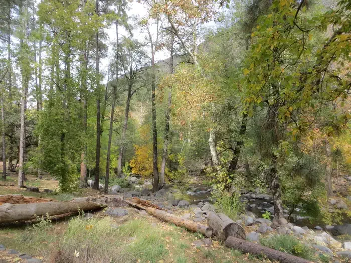 Manzanita.CampingPhoto: Recreation.gov (RIDB) / public domain3.9 mi
Source: Roamze catalog (indexable pages within 10 miles, PostGIS distance)
 Janice PlaceMountain biking · ~2 min drivePhoto: inkknife_2000 (7.5 million views +), CC BY-SA 2.0 (via Wikimedia Commons)Frog Tank LoopMountain biking · ~2 min drivePhoto: inkknife_2000 (7.5 million views +), CC BY-SA 2.0 (via Wikimedia Commons)WillardMountain biking · ~3 min drivePhoto: inkknife_2000 (7.5 million views +), CC BY-SA 2.0 (via Wikimedia Commons)
 North WilsonMountain biking · ~7 min drivePhoto: davidpinter, CC BY 3.0 (via Wikimedia Commons)
 TelephoneMountain biking · ~8 min drivePhoto: inkknife_2000 (7.5 million views +), CC BY-SA 2.0 (via Wikimedia Commons)
 Wilson MountainMountain biking · ~8 min drivePhoto: On^ste82, CC BY 3.0 (via Wikimedia Commons)
 A B YoungMountain biking · ~9 min drivePhoto: inkknife_2000 (7.5 million views +), CC BY-SA 2.0 (via Wikimedia Commons)
 Cave SpringsMountain biking · ~9 min drivePhoto: inkknife_2000 (7.5 million views +), CC BY-SA 2.0 (via Wikimedia Commons)
 Wilson CanyonMountain biking · ~9 min drivePhoto: Don Graham from Redlands, CA, USA - God bless it!, CC BY-SA 2.0 (via Wikimedia Commons)
 Oak Creek Spur AMountain biking · ~9 min drivePhoto: Brady Smith; Coconino National Forest, CC BY-SA 2.0 (via Wikimedia Commons)
Also worth it near here
 Thompson LadderHiking · ~4 min drivePhoto: inkknife_2000 (7.5 million views +), CC BY-SA 2.0 (via Wikimedia Commons)The Right WallRock climbing · ~6 min drivePhoto: Annemari Romero; Coconino National Forest, CC BY-SA 2.0 (via Wikimedia Commons)
Best months: May–July and September. Best months have typical highs of 55–85 °F, lows of 30 °F or warmer (32 °F where the station doesn't record snow), at most one snowy day and no more than 12 wet days.
Jan
46° / 17°
7 wet
Feb
47° / 19°
7 wet
Mar
53° / 23°
7 wet
Apr
60° / 27°
4 wet
May
69° / 34°
3 wet
Jun
79° / 40°
3 wet
Jul
83° / 49°
9 wet
Aug
81° / 50°
13 wet
Sep
76° / 41°
8 wet
Oct
66° / 31°
5 wet
Nov
54° / 22°
5 wet
Dec
46° / 16°
7 wet
Typical high / low (°F) and days with rain or snow, 1991–2020. Measured at Mund'S Park, AZ, 2.3 mi away at 6,470 ft. This station doesn't record snowfall. Source: NOAA NCEI U.S. Climate Normals 1991–2020.
Map and trail data © OpenStreetMap contributors
