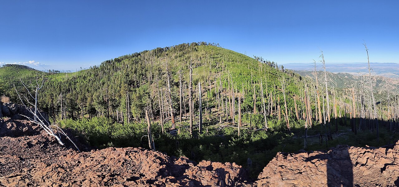
Sara Deming Trail
 Photo: w_lemay, CC BY-SA 2.0 (via Flickr)
- 1.5 mi
- round trip
- 8,340 ft
- climb
- 6,841 ft
- high point
- Out and back
- route
- Sep–May
- best months
Is Sara Deming Trail open right now?
No closures listed
The National Park Service lists no closures for Chiricahua National Monument.
As of · Source: NPS · Chiricahua National Monument. Agencies don't list every closure — check before you go.
The Sara Deming Trail is a 1.5-mile moderate hike in Arizona's Chiricahua National Monument, within the Chiricahua National Monument Wilderness. The National Park Service manages the land, and the trail is an out-and-back that starts and ends at the high point, 6,841 feet, with a total elevation gain of 892 feet over the course of the round trip. The route is a short, steep climb. The steepest stretch comes at about a mile in, with a grade of 22 percent, and the trail drops back down to 5,923 feet at the low point before returning to the top. The Heart of Rocks Loop lies just 0.1 mile away, and Inspiration Point and Big Balanced Rock are each about 0.7 mile off. Spring and fall are the most comfortable times to go. Typical averages from a nearby weather station show April highs around 74°F and October highs around 76°F, while July and August bring highs near 90°F and about 12 wet days a month. That station sits roughly 1,500 feet below the trail, so temperatures on the route run cooler. Rustler Park campground is about 6.6 miles away, and Sycamore and Herb Martyr campgrounds are both within about 10 miles.
 Heart of Rocks LoopHikingPhoto: w_lemay, CC BY-SA 2.0 (via Flickr)0.1 mi
 HailstoneHikingPhoto: w_lemay, CC BY-SA 2.0 (via Flickr)0.7 mi
 Mushroom RockHikingPhoto: Caddymob at English Wikipedia, CC BY 3.0 (via Wikimedia Commons)0.7 mi
- Big Balanced RockHikingPhoto: Caddymob at English Wikipedia, CC BY 3.0 (via Wikimedia Commons)0.7 mi
- Inspiration PointHikingPhoto: w_lemay, CC BY-SA 2.0 (via Flickr)0.7 mi
- Rustler ParkCamping6.6 mi
- SycamoreCamping9.3 mi
- Herb MartyrCamping9.9 mi
Source: Roamze catalog (indexable pages within 10 miles, PostGIS distance)
- Heart of Rocks LoopHiking · Next doorPhoto: w_lemay, CC BY-SA 2.0 (via Flickr)
- Mushroom RockHiking · ~1 min drivePhoto: Caddymob at English Wikipedia, CC BY 3.0 (via Wikimedia Commons)
- Hoovey CanyonHiking · ~6 min drive
- HailstoneHiking · ~1 min drivePhoto: w_lemay, CC BY-SA 2.0 (via Flickr)
- Lower RhyoliteHiking · ~1 min drivePhoto: w_lemay, CC BY-SA 2.0 (via Flickr)
- Fife CanyonHiking · ~8 min drive
- Inspiration PointHiking · ~1 min drivePhoto: w_lemay, CC BY-SA 2.0 (via Flickr)
 Echo CanyonHiking · ~2 min drivePhoto: w_lemay, CC BY-SA 2.0 (via Flickr)
- Bootlegger Trail #257Hiking · ~12 min drive
- Big Balanced RockHiking · ~1 min drivePhoto: Caddymob at English Wikipedia, CC BY 3.0 (via Wikimedia Commons)
Best time to visit Sara Deming Trail
Best months: September–May. Best months have typical highs of 55–85 °F, lows of 30 °F or warmer (32 °F where the station doesn't record snow), at most one snowy day and no more than 12 wet days.
Jan
56° / 30°
5 wet
Feb
61° / 33°
5 wet
Mar
67° / 37°
4 wet
Apr
74° / 40°
2 wet
May
83° / 49°
2 wet
Jun
91° / 57°
4 wet
Jul
90° / 60°
12 wet
Aug
87° / 60°
12 wet
Sep
84° / 57°
7 wet
Oct
76° / 47°
4 wet
Nov
66° / 38°
4 wet
Dec
56° / 31°
5 wet
Typical high / low (°F) and days with rain or snow, 1991–2020. Measured at Chiricahua Nm, AZ, 2.2 mi away at 5,300 ft. The station sits about 1,500 ft lower than this place, so expect it a little cooler here. Source: NOAA NCEI U.S. Climate Normals 1991–2020.