Siouxon Peak
- 4,169 ft
- summit
- 2
- ways up
Is Siouxon Peak open right now?
Alert in the area
The Forest Service lists 6 alerts for Gifford Pinchot National Forest.
Fire Restrictions
Agency alert covering Gifford Pinchot National Forest · USFS · Gifford Pinchot National Forest
Seasonal Road Closures
Agency alert covering Gifford Pinchot National Forest · USFS · Gifford Pinchot National Forest
Road Repairs & Road Closures in 2026
Agency alert covering Gifford Pinchot National Forest · USFS · Gifford Pinchot National Forest
Washout on Forest Road 93
Agency alert covering Gifford Pinchot National Forest · USFS · Gifford Pinchot National Forest
Upper State Route 504 closed at milepost 45.2 due to large slide
Agency alert covering Gifford Pinchot National Forest · USFS · Gifford Pinchot National Forest
As of · Source: USFS · Gifford Pinchot National Forest. Agencies don't list every closure — check before you go.
Siouxon Peak is a summit in Washington's Gifford Pinchot National Forest, within the Mount St. Helens National Volcanic Monument ranger district. The nearest town is Cougar, about 9 miles away. Close by, the North Fork Siouxon and Chinook Creek hikes start within about a mile and a half, and Range Creek offers canoeing under 2 miles off. For camping, Paradise Creek Campground sits just under 10 miles away.
Conditions and forecast
Daily highs and lows, wind and the chance of precipitation at the summit and route start for the next 7 days, from the Open-Meteo model.
- Summit elevation
- 4,169 ft
Elevation from USGS 3D Elevation Program terrain data (about 10 m resolution).
- Siouxon PeakEasyabout 69 ft of climbing0.4 mi
- Huffman PeakHardabout 9,572 ft of climbing17.0 mi round trip
Compare the routes Siouxon Peak Huffman Peak Climbing About 69 ft About 9,572 ft Round trip 0.4 mi 17.0 mi Difficulty Easy Hard Terrain Hike Hike Map © Mapbox © OpenStreetMap contributors Questions about Siouxon Peak
How tall is Siouxon Peak?
4,169 ft (1,271 m).
How many routes go to the summit of Siouxon Peak?
2: Siouxon Peak and Huffman Peak.
What is the shortest route up Siouxon Peak?
Siouxon Peak, about 0.4 mi.
- Mount Mitchell3,965 ft · Washington1 route4.0 mi away
- Sister Rocks4,264 ft · Washington1 route5.8 mi away
- Observation Peak4,214 ft · Washington1 route7.1 mi away
- Rock Point3,815 ft · Washington1 route7.4 mi away
- Soda Peaks4,534 ft · Washington1 route8.4 mi away
- House Rock2,497 ft · Washington1 route10 mi away
- North Fork SiouxonHiking0.6 mi
- Chinook CreekHiking1.3 mi
- Range CreekCanoeing1.9 mi
- WildcatHiking2.2 mi
- Siouxon CreekCanoeing3 mi
- Columbia GorgeRock climbing4.6 mi
- Paradise Creek campgroundCamping9.8 mi
- Govt. Mineral Springs CgCamping9.9 mi
Source: Roamze catalog (indexable pages within 10 miles, PostGIS distance)
 Mount Saint HelensSummit · ~24 min drivePhoto: U.S. Forest Service- Pacific Northwest Region, Public domain (via Wikimedia Commons)
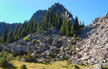 Lemei RockSummit · ~31 min drivePhoto: FizzyUnicorn, CC BY-SA 3.0 (via Wikimedia Commons)
 Greenleaf PeakSummit · ~36 min drivePhoto: Walter Siegmund (talk), CC BY-SA 3.0 (via Wikimedia Commons)
 Tumtum MountainSummit · ~18 min drivePhoto: Seattle Skier, CC BY-SA 4.0 (via Wikimedia Commons)
 Table MountainSummit · ~38 min drivePhoto: Walter Siegmund (talk), CC BY-SA 3.0 (via Wikimedia Commons)
- Mount MitchellSummit · ~7 min drive
- Sister RocksSummit · ~10 min drive
- Observation PeakSummit · ~12 min drive
- Rock PointSummit · ~13 min drive
- Soda PeaksSummit · ~14 min drive
