Beacon Rock State Park Campground
Campground
Campground · 0.4 mi from the trail
 Photo: U.S. Geological Survey, Public domain (via Wikimedia Commons)
Caution at last check
Agency alerts are in effect for this area; weather is good · USFS, OpenWeather · checked 17 h ago
Closure in the area
There's a closure order in Columbia River Gorge National Scenic Area. It doesn't name Beacon Rock State Park, so check the source for the area it covers.
Eagle Creek Area and Trail Closure
Agency closure covering Columbia River Gorge National Scenic Area · Order 06-22-01-26-04 · USFS · Columbia River Gorge National Scenic Area
Eagle Creek Fire Area Closure - CRGNSA and Mt. Hood
Agency alert covering Columbia River Gorge National Scenic Area · Order 06-22-01-26-04 · USFS · Columbia River Gorge National Scenic Area
As of · Source: USFS · Columbia River Gorge National Scenic Area. Agencies don't list every closure — check before you go.
Beacon Rock State Park is a Washington state park in the Columbia River Gorge National Scenic Area, about 2.5 miles from the town of North Bonneville. The land is managed by State Park and Recreation, and the park sits within the Beacon Rock state park unit. Summer is the most comfortable time to visit. Typical averages from the nearby Bonneville Dam weather station show July and August highs around 79 to 80°F with only four or five wet days a month, while winter brings highs in the low 40s and rain on more than 20 days a month. The Beacon Rock Trail and River to Rock Trail both start within a tenth of a mile, and the Northwest Face climbing area is just as close. For paddling, Hamilton Creek is about 3.6 miles away.
Beacon Rock State Park Campground
Campground
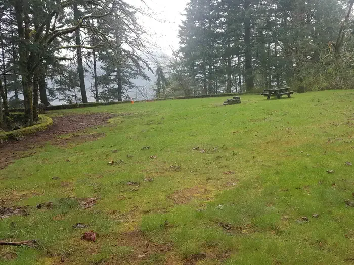
 If it rainsIan Poellet, CC BY-SA 4.0 · Wikimedia Commons
Places © OpenStreetMap contributors, Places © Overture Maps Foundation · Photos: Ian Poellet, CC BY-SA 4.0 (commons)
More in Mount Hood Villages Beacon Rock TrailHikingPhoto: mjfmjfmjf, CC BY 2.0 (via Flickr)0.1 mi
 River to Rock TrailHikingPhoto: mjfmjfmjf, CC BY 2.0 (via Flickr)0.1 mi
 North Forest BouldersRock climbingPhoto: Kingofthedead, CC BY-SA 4.0 (via Wikimedia Commons)0.1 mi
 Eagle Creek Overlook Grp SiteCampingPhoto: Recreation.gov (RIDB) / public domain4.5 mi
Source: Roamze catalog (indexable pages within 10 miles, PostGIS distance)
 Benson State Recreation AreaState park · ~8 min drivePhoto: Sarah McDevitt from Oregon, USA, CC BY 2.0 (via Wikimedia Commons)
 Rooster Rock State ParkState park · ~20 min drivePhoto: EncMstr, CC BY-SA 3.0 (via Wikimedia Commons)
 George W. Joseph State Natural AreaState park · ~21 min drivePhoto: frankenstoen, CC BY 2.0 (via Wikimedia Commons)
 Guy W. Talbot State ParkState park · ~21 min drivePhoto: David Prasad from Welches, OR., United States, CC BY-SA 2.0 (via Wikimedia Commons)
 Starvation Creek State ParkState park · ~28 min drivePhoto: --b--, CC BY-SA 2.0 (via Wikimedia Commons)
 Dabney State Recreation AreaState park · ~30 min drivePhoto: Ian Poellet, CC BY-SA 3.0 (via Wikimedia Commons)
 Lewis And Clark State Recreation SiteState park · ~31 min drivePhoto: Ian Poellet (User:Werewombat), CC BY-SA 3.0 (via Wikimedia Commons)
 Battle Ground LakeState park · ~44 min drivePhoto: David Burn from Portland, OR, USA, CC BY-SA 2.0 (via Wikimedia Commons)
 Bonnie Lure State Recreation AreaState park · ~45 min drivePhoto: brx0, CC BY-SA 2.0 (via Wikimedia Commons)
 Koberg Beach State Recreation SiteState park · ~48 min drivePhoto: Tedder, CC BY 3.0 (via Wikimedia Commons)
Also worth it near here
Beacon Rock TrailHiking · Next doorPhoto: mjfmjfmjf, CC BY 2.0 (via Flickr)North Forest BouldersRock climbing · Next doorPhoto: Kingofthedead, CC BY-SA 4.0 (via Wikimedia Commons) Elowah FallsWaterfall · ~3 min drivePhoto: Walter Siegmund (talk), CC BY-SA 3.0 (via Wikimedia Commons)
Best months: June–September. Best months have typical highs of 55–85 °F, lows of 30 °F or warmer (32 °F where the station doesn't record snow), at most one snowy day and no more than 12 wet days.
Jan
43° / 34°
21 wet · 2 snow
Feb
47° / 36°
18 wet · 1 snow
Mar
53° / 38°
20 wet
Apr
59° / 42°
18 wet
May
67° / 48°
15 wet
Jun
72° / 52°
11 wet
Jul
79° / 57°
5 wet
Aug
80° / 57°
4 wet
Sep
74° / 53°
8 wet
Oct
62° / 47°
15 wet
Nov
50° / 40°
20 wet
Dec
42° / 35°
22 wet · 1 snow
Typical high / low (°F) and days with rain or snow, 1991–2020. Measured at Bonneville Dam, OR, 3.4 mi away at 62 ft. Source: NOAA NCEI U.S. Climate Normals 1991–2020.
