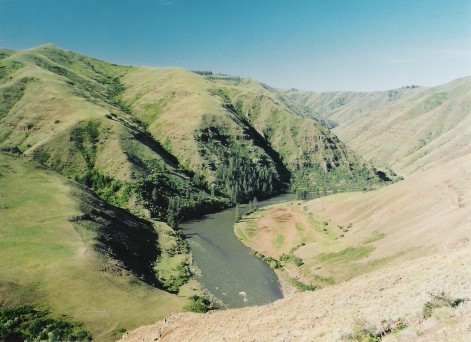
Middle Fork John Day River
 Photo: Sam Beebe, CC BY 2.0 (via Wikimedia Commons)
- 41.3 mi
- distance
- 4,252 ft
- high point
- May–Sep
- best months
Is Middle Fork John Day River open right now?
No closures listed
The Forest Service lists no closures for Malheur National Forest.
As of · Source: USFS · Malheur National Forest. Agencies don't list every closure — check before you go.
The Middle Fork John Day River is a canoeing destination in eastern Oregon, running through the Blue Mountain Ranger District of the Malheur National Forest, which the Forest Service manages. The route is roughly 41 miles long. Summer is the most comfortable time to paddle. July and August typically reach highs around 83°F with only four or five wet days a month, according to typical averages from a nearby weather station. Winter is cold, with January highs around 34°F and lows near 15°F. Several campgrounds sit within a few miles of the river, including Middle Fork Campground and Lower Camp Creek Forest Camp. The Princess Trail and Lost Lake Trail are also close by.
- Lower Camp Creek Forest CampCamping5.1 mi
- Middle Fork CgCamping5.3 mi
- Princess TrailHiking5.5 mi
- Head O' Boulder Forest CampCamping5.6 mi
- Deerhorn Forest CampCamping6.7 mi
- Lost Lake TrailHiking8.1 mi
 Saddle Camp - Lost Creek tie trailHikingPhoto: Forest Service Pacific Northwest Region, Public Domain Mark (via Flickr)8.6 mi
- Saddle Camp TrailHikingPhoto: Forest Service Pacific Northwest Region, Public Domain Mark (via Flickr)8.7 mi
Source: Roamze catalog (indexable pages within 10 miles, PostGIS distance)
 Grande Ronde RiverCanoeing · ~1h 3m drivePhoto: Dsdugan, Public domain (via Wikimedia Commons)
- Anthony Lake Boat LaunchBoat launch · ~52 min drive
 Malheur RiverCanoeing · ~1h 15m drivePhoto: Bureau of Land Management, Public domain (via Wikimedia Commons)
- Grande Ronde Boat LaunchBoat launch · ~52 min drive
- Clear CreekCanoeing · ~21 min drive
- Union Creek Boat LaunchBoat launch · ~57 min drive
- Granite CreekCanoeing · ~28 min drive
- Mason Dam Boat LaunchBoat launch · ~58 min drive
- North Fork Burnt RiverCanoeing · ~33 min drive
- Magone Lake Boat LaunchBoat launch · ~24 min drive
Also worth it near here
- Saddle Camp - Lost Creek tie trailHiking · ~15 min drivePhoto: Forest Service Pacific Northwest Region, Public Domain Mark (via Flickr)
 Sheep RockSummit · ~20 min drivePhoto: Finetooth, CC BY-SA 3.0 (via Wikimedia Commons)
- Northeast OregonRock climbing · ~30 min drive
- Antlers Guard Station CabinCamping · ~35 min drive
Best time to visit Middle Fork John Day River
Best months: May–September. Best months have typical highs of 55–85 °F, lows of 30 °F or warmer (32 °F where the station doesn't record snow), at most one snowy day and no more than 12 wet days.
Jan
34° / 15°
14 wet
Feb
39° / 18°
12 wet
Mar
46° / 23°
13 wet
Apr
53° / 28°
12 wet
May
62° / 34°
12 wet
Jun
71° / 39°
9 wet
Jul
83° / 43°
5 wet
Aug
83° / 42°
4 wet
Sep
73° / 35°
5 wet
Oct
59° / 28°
7 wet
Nov
42° / 22°
12 wet
Dec
33° / 16°
15 wet
Typical high / low (°F) and days with rain or snow, 1991–2020. Measured at Austin 3 S, OR, 12.1 mi away at 4,213 ft. This station doesn't record snowfall. Source: NOAA NCEI U.S. Climate Normals 1991–2020.
