Sandbanks Dunes Trail
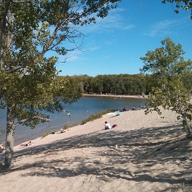 Photo: mathewingram, CC BY 2.0 (via Flickr)
- 0.5 mi
- round trip
- 89 ft
- climb
- Out and back
- route
- Moderate
- difficulty
- Jun–Sep
- best months
Sandbanks Dunes Trail is a short, out-and-back hike in New York, set in a landscape of dunes and low ground. The trail covers about a mile, with a total climb of about 89 feet up to a high point of 282 feet, and it is rated moderate. The route starts at roughly 257 feet and ends at the same level, with a small rise in the middle, about 0.4 miles in, where the grade reaches about 4 percent. Summer is the most comfortable time to go. Typical averages from a nearby weather station run to highs around 77 to 81°F in June through August, with July the warmest month. That station sits at a similar elevation to the trail, so conditions on the dunes should be comparable. The hike takes about half an hour. The Woodlands Trail lies just 0.2 miles away, so it's easy to pair the two on a short outing.
Best time to go · Jun–Sep
Best time to visit Sandbanks Dunes Trail
Best months: June–September. Best months have typical highs of 55–85 °F, lows of 30 °F or warmer (32 °F where the station doesn't record snow), at most one snowy day and no more than 12 wet days.
Jan
34° / 17°
19 wet · 16 snow
Feb
36° / 18°
17 wet · 14 snow
Mar
44° / 25°
15 wet · 9 snow
Apr
56° / 35°
15 wet · 3 snow
May
68° / 47°
14 wet
Jun
77° / 56°
12 wet
Jul
81° / 61°
11 wet
Aug
80° / 61°
12 wet
Sep
73° / 53°
12 wet
Oct
61° / 42°
16 wet · 1 snow
Nov
49° / 32°
16 wet · 5 snow
Dec
39° / 24°
19 wet · 12 snow
Typical high / low (°F) and days with rain or snow, 1991–2020. Measured at Webster 2 Ne, NY, 46.4 mi away at 275 ft. Source: NOAA NCEI U.S. Climate Normals 1991–2020.
Keep exploring — more trails worth the drive
 Photo: Community Archives, Public domain (via Wikimedia Commons)
Gunpo Trail
~31 min drive
3.14-mile out-and-back trail in New York with 338 ft elevation gain
 Photo: Community Archives, Public domain (via Wikimedia Commons)
Trans Canada Trail
~1h 7m drive
32.28-mile out-and-back trail in New York with 1,313 ft elevation gain
 Photo: Carrotflower Productions International, CC BY-SA 2.0 (via Flickr)
Drumlin Trail
~1h 20m drive
0.73-mile point-to-point trail in New York with 173 ft gain
 Photo: sillygwailo, CC BY 2.0 (via Flickr)
Newcastle Trail
~37 min drive
Newcastle Trail is a 3.19-mile point-to-point trail in New York.
HIKE
Trans Canada Trail
~1h 7m drive
35.74-mile out-and-back trail in New York with 1,113 ft elevation gain.
HIKE
Hastings Heritage Trail
~53 min drive
A moderate 2.73-mile out-and-back trail in New York featuring dirt and gravel road surfaces.
 Photo: Bobolink, CC BY 2.0 (via Flickr)
Batawa Riverfront Trail
~41 min drive
1.44-mile out-and-back trail in New York with 108 ft of elevation gain
HIKE
Trans Canada Trail Connection
~1h 18m drive
19.6-mile out-and-back trail in New York with 414 ft elevation gain.
HIKE
Rt K&p Blue Loop
~1h 18m drive
6.04-mile point-to-point trail in New York with 302 ft gain.
 Photo: Bobolink, CC BY 2.0 (via Flickr)
Trans Canada Trail
~55 min drive
3.8-mile out-and-back trail in New York with 168 ft elevation gain/loss.

Map and trail data © OpenStreetMap contributors
