Bonanza Trail
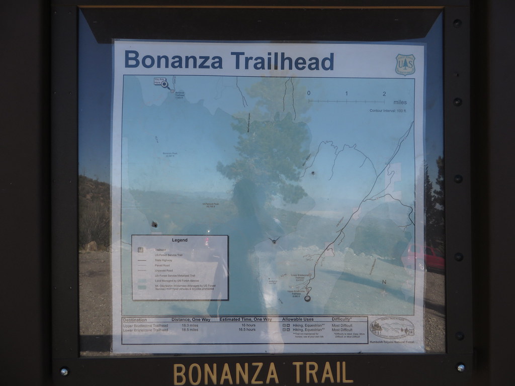 Photo: Ken Lund — CC BY-SA 2.0 (via Flickr)
- 25.8 mi
- round trip
- 3,153 ft
- climb
- 10,282 ft
- high point
- Out and back
- route
Is Bonanza Trail open right now?
Closure in the area
There's a closure order in Humboldt-Toiyabe National Forest. It doesn't name Bonanza Trail, so check the source for the area it covers.
Elephant Fire Closure
Agency closure covering Humboldt-Toiyabe National Forest · Order 04-17-26-01-04 · USFS · Humboldt-Toiyabe National Forest
Area, Road, and Trail Closures (Spring Mountains National Recreation Area)
Agency alert covering Humboldt-Toiyabe National Forest · Order 04-17-25-04 · USFS · Humboldt-Toiyabe National Forest
Year-Round Fire Restrictions (Spring Mountains National Recreation Area)
Agency alert covering Humboldt-Toiyabe National Forest · Order 04-17-24-01 · USFS · Humboldt-Toiyabe National Forest
Vehicle Snow Chain Requirements during Inclement Weather (Spring Mountains National Recreation Area)
Agency alert covering Humboldt-Toiyabe National Forest · Order 04-17-23-01 · USFS · Humboldt-Toiyabe National Forest
Rainbow Canyon Flood Diversion Structure Closure (Spring Mountains National Recreation Area)
Agency alert covering Humboldt-Toiyabe National Forest · Order 04-17-15-01 · USFS · Humboldt-Toiyabe National Forest
As of · Source: USFS · Humboldt-Toiyabe National Forest. Agencies don't list every closure — check before you go.
Bonanza Trail is a hard hike in Nevada's Spring Mountains National Recreation Area, part of the Humboldt-Toiyabe National Forest. The trail is an out-and-back route of about 25.8 miles, with a total elevation gain of 3,153 feet. It starts at the Bonanza Trailhead, where the parking is labeled "BONANZA TRAILHEAD," and it climbs from a low point of about 7,516 feet to a high point of about 10,282 feet. The trail is managed by the Forest Service, and bikes are not allowed. Plan for a full day on foot, with time to rest and take in the high-country setting. Several other routes lie within a couple of miles, including Arrowleaf Trail and Loopdy Trail. For an overnight stay, McWilliams campground is about 6 miles away, and the Icehouse climbing area is about 7.5 miles off.
Keep exploring — more trails worth the drive
 Photo: Ken Lund, CC BY-SA 2.0 (via Flickr)
Arrowleaf Trail
~2 min drive
8.26-mile out-and-back trail in Nevada with 1,776 ft gain/loss.
 Photo: Ken Lund, CC BY-SA 2.0 (via Flickr)
SHORTAWN FOXTAIL TRAIL
~4 min drive
1.78-mile out-and-back trail in Nevada with 237 ft elevation gain and loss.
 Photo: bahniuk, CC BY 3.0 (via Wikimedia Commons)
North Loop
~15 min drive
9.61-mile loop trail in Nevada with 2,725 ft elevation gain.
 Photo: Ken Lund, CC BY-SA 2.0 (via Flickr)
Charleston Peak Trail South Loop
~14 min drive
8.40-mile out-and-back trail in Nevada with 949 ft elevation gain and 5,115 ft loss.
 Photo: bahniuk, CC BY 3.0 (via Wikimedia Commons)
North Camp Loop
~13 min drive
2.1-mile out-and-back trail in Nevada with 1,488 ft gain and 8,860 ft max elevation
 Photo: redlicks, CC BY 3.0 (via Wikimedia Commons)
Wildhorse Ridge
~14 min drive
1.52-mile out-and-back trail in Nevada with 659 ft elevation gain/loss
 Photo: Ken Lund, CC BY-SA 2.0 (via Flickr)
Trail Canyon
~16 min drive
3.91-mile out-and-back trail in Nevada with 1,527 ft elevation gain.
Photo: redlicks, CC BY 3.0 (via Wikimedia Commons)Wildhorse Canyon
~15 min drive
2.42-mile out-and-back trail in Nevada with 1,215 ft gain/loss
 Photo: bahniuk, CC BY 3.0 (via Wikimedia Commons)
Robber's Roost Trail
~16 min drive
0.6-mile out-and-back hike in Nevada with 506 ft gain and 8,234 ft max elevation.
 Photo: Ken Lund, CC BY-SA 2.0 (via Flickr)
Bristlecone
~11 min drive
10.20-mile out-and-back trail in Nevada with 590 ft elevation gain.

Map and trail data © OpenStreetMap contributors
