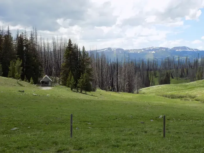
Black Butte
 Photo: Mike Cline, CC BY-SA 3.0 (via Wikimedia Commons)
- 10,539 ft
- summit
Is Black Butte open right now?
Closure in the area
There's a closure order in Beaverhead-Deerlodge National Forest. It doesn't name Black Butte, so check the source for the area it covers (2 listed).
Annual Food Storage Order
Agency closure covering Beaverhead-Deerlodge National Forest · Order 02-00-22-02 · USFS · Beaverhead-Deerlodge National Forest
Pallet Prohibition Order Butte Ranger District
Agency closure covering Beaverhead-Deerlodge National Forest · Order 01020425-01 · USFS · Beaverhead-Deerlodge National Forest
Lost Creek Area - Road Closure
Agency alert covering Beaverhead-Deerlodge National Forest · USFS · Beaverhead-Deerlodge National Forest
Montana BDR Alternative Route
Agency alert covering Beaverhead-Deerlodge National Forest · USFS · Beaverhead-Deerlodge National Forest
Lost Creek Area - Road Closure
Agency alert covering Beaverhead-Deerlodge National Forest · Order 01020826-02 · USFS · Beaverhead-Deerlodge National Forest
As of · Source: USFS · Beaverhead-Deerlodge National Forest. Agencies don't list every closure — check before you go.
Black Butte is a summit in Madison County, Montana, within the Madison Ranger District of the Beaverhead-Deerlodge National Forest. The nearest town is Lakeview, about 21 miles away. The peak rises high in the district's backcountry and makes a natural goal for hikers already exploring the surrounding trails. The closest trail is Rebish Cutoff, about 1.3 miles away. Black Butte Cabin sits about 1.7 miles off for an overnight stay, and the Horse Creek trail lies about 3.3 miles out. Cottonwood Campground is about 7.7 miles away.
Conditions and forecast
Daily highs and lows, wind and the chance of precipitation at the summit for the next 7 days, from the Open-Meteo model.
- Summit elevation
- 10,539 ft
Elevation from USGS 3D Elevation Program terrain data (about 10 m resolution).
We don't know of a mapped trail or route to the summit of Black Butte. Plan the approach with local maps, a guidebook or a local guide, and check conditions before you go.
Questions about Black Butte
How tall is Black Butte?
10,539 ft (3,212 m).
Is there a trail to the top of Black Butte?
We don't know of a mapped trail or route to the summit. Plan the approach with local maps, a guidebook or a local guide.
- REBISH CUTOFFHiking1.3 mi
- Black Butte CabinCamping1.7 mi
- HORSE CREEKHiking3.3 mi
- BARNETT TRAILHiking3.3 mi
- STANDARD CREEKHiking4.4 mi
 West Fork Cabin (s of Ennis)CampingPhoto: Recreation.gov (RIDB) / public domain7.1 mi
- Vig/Brunt Creek/Cottonwood Road Rest AreasCamping7.5 mi
- Cottonwood CampgroundCamping7.7 mi
Source: Roamze catalog (indexable pages within 10 miles, PostGIS distance)
 The HelmetSummit · ~43 min drivePhoto: Mike Cline, CC BY-SA 4.0 (via Wikimedia Commons)
 Cedar MountainSummit · ~48 min drivePhoto: Mike Cline, CC BY-SA 4.0 (via Wikimedia Commons)
 Mount JeffersonSummit · ~50 min drivePhoto: Metrodyne, Public domain (via Wikimedia Commons)
 Sawtell PeakSummit · ~53 min drivePhoto: DJ Cane, CC BY-SA 4.0 (via Wikimedia Commons)
 Fan MountainSummit · ~54 min drivePhoto: Mike Cline, CC BY-SA 4.0 (via Wikimedia Commons)
 Gray PeakSummit · ~1h 22m drivePhoto: Bryan Harry, Public domain (via Wikimedia Commons)
 Echo PeakSummit · ~1h 22m drivePhoto: J. P. Iddings, Public domain (via Wikimedia Commons)
 Mount HaynesSummit · ~1h 23m drivePhoto: Mike Cline, Public domain (via Wikimedia Commons)
 Storm CastleSummit · ~1h 23m drivePhoto: Mike Cline, CC BY-SA 4.0 (via Wikimedia Commons)
 White PeaksSummit · ~1h 24m drivePhoto: Mike Cline, Public domain (via Wikimedia Commons)
