Zapata Falls Campground
- from $11
- fee
- May–Sep
- best months
- At 7,765 ft
- San Luis Valley Field Office
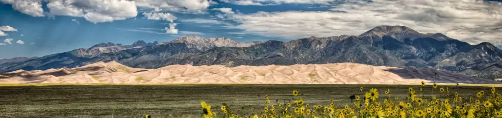
A short drive up the gravel road that leads to the Bureau of Land Management’s Zapata Falls Campground (CG) will let visitors to the area see the San Luis Valley and Great Sand Dunes National Park & Preserve from a whole new perspective. The campground offers bird’s-eye views of the valley floor below, the San Juan Mountains to the west, the adjacent Great Sand Dunes National Park and Preserve, and several 14er’s and many other towering peaks of the Sangre de Cristo Mountain range that Zapata Falls CG sits on — not to mention spectacular sunrises, sunsets and night skies! Zapata Falls CG has 23 single campsites, 1 group site and 1 camp host site nestled among piñon pines along two one-mile long loops. The sites on one loop are designed for tent campers. Parking spurs on the second loop vary a little in length but in general can handle RVs, towed campers, or other configurations of vehicles up to about 50 feet long. A new trailhead in the campground supplies a link to the South Zapata Creek Trail and the Sangre de Cristo Wilderness. A second trail, next door to the campground in the day-use area, leads visitors on a mildly steep half-mile hike to Zapata Falls, which gives the campground its name.
Local outfitters
- Ramble13 mi away
- Valley View Hot Springs41 mi away
Not on Roamze yet. Their page has how to reach them.
 California PeakHikingPhoto: Eric Johnson, CC BY-SA 3.0 (via Wikimedia Commons)2 mi
- Twin PeaksHikingPhoto: Eric Johnson, CC BY-SA 3.0 (via Wikimedia Commons)2 mi
- Zapata Falls TrailMountain biking2.2 mi
- RaspberryHiking3.1 mi
 Oasis CampgroundCampingPhoto: Thomson M, CC BY 3.0 (via Wikimedia Commons)5.1 mi
- Great Sand Dunes OasisCamping5.2 mi
 Mosca CampgroundCampingPhoto: Doss Imaging, CC BY 3.0 (via Wikimedia Commons)8.4 mi
 Pinon Flats CampgroundCampingPhoto: Recreation.gov (RIDB) / public domain9.4 mi
Source: Roamze catalog (indexable pages within 10 miles, PostGIS distance)
 Zapata Falls CampgroundCamping · ~4 min drivePhoto: Fredlyfish4, CC BY-SA 4.0 (via Wikimedia Commons)
- Oasis CampgroundCamping · ~9 min drivePhoto: Thomson M, CC BY 3.0 (via Wikimedia Commons)
- Mosca CampgroundCamping · ~14 min drivePhoto: Doss Imaging, CC BY 3.0 (via Wikimedia Commons)
- Pinon Flats CampgroundCamping · ~16 min drive
 Base Camp Family CampgroundCamping · ~22 min drivePhoto: David Herrera from Albuquerque, NM, Bernalillo, CC BY 2.0 (via Wikimedia Commons)
 Camper VillageCamping · ~45 min drivePhoto: Ej Lowell, CC BY-SA 3.0 (via Wikimedia Commons)
- Bear Lake Campground (co)Camping · ~56 min drive
 Circle The Wagons RV ParkCamping · ~57 min drivePhoto: Jeffrey Beall, CC BY 4.0 (via Wikimedia Commons)
- Blue Lake Campground - San Isabel NF (CO)Camping · ~57 min drive
- Sammies Motel/RVCamping · ~57 min drivePhoto: Jeffrey Beall, CC BY 4.0 (via Wikimedia Commons)
Also worth it near here
- California PeakHiking · ~3 min drivePhoto: Eric Johnson, CC BY-SA 3.0 (via Wikimedia Commons)
- Zapata Falls TrailMountain biking · ~4 min drive
 Zapata FallsWaterfall · ~4 min drivePhoto: XenonofArcticus (talk), CC BY-SA 3.0 (via Wikimedia Commons)
 Twin PeaksSummit · ~8 min drivePhoto: David Herrera, CC BY 2.5 (via Wikimedia Commons)
Best time to visit Zapata Falls Campground
Best months: May–September. Best months have typical highs of 55–85 °F, lows of 30 °F or warmer (32 °F where the station doesn't record snow), at most one snowy day and no more than 12 wet days.
Jan
37° / 4°
3 wet
Feb
42° / 10°
3 wet
Mar
52° / 20°
5 wet
Apr
59° / 26°
5 wet
May
68° / 35°
6 wet
Jun
78° / 44°
6 wet
Jul
83° / 49°
8 wet
Aug
80° / 47°
10 wet
Sep
75° / 39°
6 wet
Oct
63° / 28°
5 wet
Nov
49° / 15°
4 wet
Dec
36° / 5°
3 wet
Typical high / low (°F) and days with rain or snow, 1991–2020. Measured at Blanca 4 Nw, CO, 10.4 mi away at 7,709 ft. This station doesn't record snowfall. Source: NOAA NCEI U.S. Climate Normals 1991–2020.
Zapata Falls Campground
Book on Recreation.gov
