Mountain · 2 routes
Cleghorn Mountain
5,334 ft · California
- Summit
- 5,334 ft
- Routes
- 2 ways up
Routes up Cleghorn Mountain
- Cleghorn Ridge TrailEasyabout 327 ft of climbing0.9 mi round tripSee the route
- Cleghorn Ridge TrailHardabout 2,133 ft of climbing15.1 mi round tripSee the route
| Cleghorn Ridge Trail | Cleghorn Ridge Trail | |
|---|---|---|
| Climbing | About 327 ft | About 2,133 ft |
| Round trip | 0.9 mi | 15.1 mi |
| Difficulty | Easy | Hard |
| Terrain | Hike | Hike |
About Cleghorn Mountain
Cleghorn Mountain is a summit of 5,334 feet in the Front Country Ranger District of San Bernardino National Forest in California, about 6 miles from the community of Lytle Creek. Late spring and early fall are the most comfortable times to go. Typical averages from the nearby Lake Arrowhead weather station show May highs around 67°F and September highs around 74°F, while winter brings highs in the low 40s and a few snowy days each month. The Cleghorn Ridge Trail starts just 0.1 mile away, and the Summit Trail is about 3 miles off. Within roughly 6 to 7 miles you'll also find the Lake Arrowhead Area climbing area and the Lytle Creek - Cajon Pass Recreation Area for river fishing.
Forecast on Cleghorn Mountain
Daily highs and lows, wind and the chance of precipitation at the summit and route start for the next 7 days, from the Open-Meteo model.
Questions about Cleghorn Mountain
How tall is Cleghorn Mountain?
5,334 ft (1,626 m).
How many routes go to the summit of Cleghorn Mountain?
2: Cleghorn Ridge Trail and Cleghorn Ridge Trail.
What is the shortest route up Cleghorn Mountain?
Cleghorn Ridge Trail, about 0.9 mi round trip.
Mountains nearby
- Baldy Mesa4,708 ft · California2 routes6.9 mi away
- Marshall Peak4,014 ft · California1 route8.5 mi away
- Pilot Rock5,242 ft · California1 route8.9 mi away
- The Pinnacles5,728 ft · California1 route11 mi away
- Telegraph Peak8,980 ft · California2 routes11 mi away
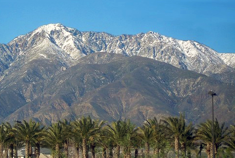 Cucamonga Peak8,859 ft · California1 route11 mi awayPhoto: Cliff Hutson; later cropping and color editing by Daniel Case., CC BY 2.0 (via Wikimedia Commons)
Facts about this place
When to go
Best time to go: Apr–Oct. The mildest months here, with typical highs of 60–82°F and lows of 36–57°F.
Typical monthly averages (not a forecast) from the Lake Arrowhead, CA weather station, 13 mi away. High / low in °F, and days with snow.
- Jan44° high29° low1 days with snow
- Feb45° high30° low1 days with snow
- Mar52° high32° low1 days with snow
- Apr60° high36° low1 days with snow
- May67° high41° low
- Jun76° high49° low
- Jul81° high57° low
- Aug82° high57° low
- Sep74° high52° low
- Oct63° high43° low
- Nov52° high34° low
- Dec43° high29° low1 days with snow
Where it is
- Front Country Ranger District · Ranger district
- San Bernardino National Forest · National forest
- Nearest town
- Lytle Creek, California · 6.1 mi
Conditions
Active alerts for Front Country Ranger District as of Oct 9, 2026:
Applewhite Picnic Area Closure
caution · posted Aug 24, 2026
caution · posted Aug 24, 2026
information · posted Aug 24, 2026
Source: USFS forest alerts
Nearby
 Cleghorn Ridge TrailHikingPhoto: Stiggs13, CC BY 2.0 (via Flickr)0.1 mi
 Summit TrailHikingPhoto: InSapphoWeTrust from Los Angeles, California, USA, CC BY-SA 2.0 (via Wikimedia Commons)2.9 mi
 Cleghorn TrailHikingPhoto: Moo.The.Cow, CC BY 2.0 (via Flickr)4.1 mi
- power pole inspector pathHiking4.1 mi
- Lytle Creek - Cajon Pass Recreation AreaRiver fishing5.7 mi
 Lake Arrowhead AreaRock climbingPhoto: bdearth, CC BY 2.0 (via Flickr)6.5 mi
- Cajon WashCanoeing7 mi
- Lake Gregory County Regional ParkLake fishing8.6 mi
Source: Roamze catalog (indexable pages within 10 miles, PostGIS distance)
Is Cleghorn Mountain open right now?
Alert in the area
The Forest Service lists 4 alerts for San Bernardino National Forest.
Safety Alert - Falling Rocks at Bonita Falls
Agency alert covering San Bernardino National Forest · USFS · San Bernardino National Forest
Upper Big Falls Area Closure
Agency alert covering Front Country Ranger District · Order 05-12-53-26-03 · USFS · Front Country Ranger District
Fire Restrictions
Agency alert covering San Bernardino National Forest · Order 05-12-00-26-05 · USFS · San Bernardino National Forest
Applewhite Picnic Area Closure
Agency alert covering Front Country Ranger District · Order 05-12-53-26-01 · USFS · Front Country Ranger District
As of · Source: USFS · San Bernardino National Forest. Agencies don't list every closure — check before you go.
Best time to visit Cleghorn Mountain
Best months: April–October. Best months have typical highs of 55–85 °F, lows of 30 °F or warmer (32 °F where the station doesn't record snow), at most one snowy day and no more than 12 wet days.
Jan
44° / 29°
6 wet · 1 snow
Feb
45° / 30°
6 wet · 1 snow
Mar
52° / 32°
6 wet · 1 snow
Apr
60° / 36°
4 wet · 1 snow
May
67° / 41°
2 wet
Jun
76° / 49°
1 wet
Jul
81° / 57°
1 wet
Aug
82° / 57°
1 wet
Sep
74° / 52°
1 wet
Oct
63° / 43°
2 wet
Nov
52° / 34°
3 wet
Dec
43° / 29°
5 wet · 1 snow
Typical high / low (°F) and days with rain or snow, 1991–2020. Measured at Lake Arrowhead, CA, 13.2 mi away at 5,205 ft. Source: NOAA NCEI U.S. Climate Normals 1991–2020.
