Chavez Crossing
Campground
The next 6 weekends are full on Recreation.gov
 Photo: Brady Smith; Coconino National Forest, CC BY-SA 2.0 (via Wikimedia Commons)
Closure in the area
There's a closure order in Red Rock Ranger District. It doesn't name Gibraltar Rock Area, so check the source for the area it covers (3 listed).
Beaver Creek Picnic Site temporarily closed
Agency closure covering Red Rock Ranger District · Order 03-04-06-26-05 · USFS · Red Rock Ranger District
Red Rock Ranger District affected by severe flooding; many closures in effect
Agency closure covering Red Rock Ranger District · USFS · Red Rock Ranger District
Banjo Bill Picnic Area Closure
Agency closure covering Red Rock Ranger District · Order 03-04-06-25-01 · USFS · Red Rock Ranger District
West Fork Temporary Area Closure - Extension to 2/27/27
Agency alert covering Coconino National Forest · Order 03-04-00-26-09 · USFS · Coconino National Forest
West Sedona Camping and Campfire Restrictions
Agency alert covering Red Rock Ranger District · Order 03-04-06-26-04 · USFS · Red Rock Ranger District
As of · Source: USFS · Red Rock Ranger District. Agencies don't list every closure — check before you go.
Gibraltar Rock Area is a climbing area in the Munds Mountain Wilderness, part of the Red Rock Ranger District of Coconino National Forest in Arizona. The Forest Service manages the land, and the area sits within designated wilderness. The climbing here is all trad, with three routes ranging from 5.9 to 5.10. Creationism and Sedona's Scenic Cruise are both 5.9, and IMAX Experience is 5.10. Sedona's Scenic Cruise was first climbed by John Burcham and James Q Martin in 2001, and IMAX Experience by Derek and Giselle Field in April 2017. Spring and fall are the most comfortable times to visit. Typical averages from a nearby weather station at Oak Creek Canyon show May highs around 78°F and October highs around 74°F, while July highs reach about 90°F. Crown Butte, a climbing area, is about 0.3 miles away, and the Church Spires Area is about 0.8 miles away. For camping, Chavez Crossing is about 2.2 miles away and Crescent Moon Ramada about 3.3 miles away.
Chavez Crossing
Campground
Stan Rose Images
Gallery
Places © OpenStreetMap contributors, Places © Overture Maps Foundation
More in Kachina Village Crown ButteRock climbingPhoto: Brady Smith; Coconino National Forest, CC BY-SA 2.0 (via Wikimedia Commons)0.3 miJim BryantMountain bikingPhoto: Brady Smith; Coconino National Forest, CC BY-SA 2.0 (via Wikimedia Commons)0.4 mi
 Jim Bryant #199HikingPhoto: jasonwoodhead23, CC BY 2.0 (via Flickr)0.6 miChurch Spires AreaRock climbingPhoto: Brady Smith; Coconino National Forest, CC BY-SA 2.0 (via Wikimedia Commons)0.8 mi
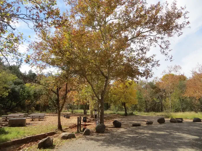 Chavez CrossingCampingPhoto: Recreation.gov (RIDB) / public domain2.2 mi
Source: Roamze catalog (indexable pages within 10 miles, PostGIS distance)
Church Spires AreaRock climbing · ~1 min drivePhoto: Brady Smith; Coconino National Forest, CC BY-SA 2.0 (via Wikimedia Commons) East Twin ButteRock climbing · ~1 min drivePhoto: Coconino National Forest, CC BY-SA 2.0 (via Wikimedia Commons)Blowjob RockRock climbing · ~2 min drivePhoto: Brady Smith; Coconino National Forest, CC BY-SA 2.0 (via Wikimedia Commons)
 Upper Religion WallRock climbing · ~2 min drivePhoto: Coconino National Forest, CC BY-SA 2.0 (via Wikimedia Commons)Church WallRock climbing · ~2 min drivePhoto: Coconino National Forest, CC BY-SA 2.0 (via Wikimedia Commons)
 VaticanRock climbing · ~2 min drivePhoto: Andrew Gnias, CC BY-SA 4.0 (via Wikimedia Commons)
 Oak Creek Spire AreaRock climbing · ~2 min drivePhoto: Coconino National Forest, CC BY-SA 2.0 (via Wikimedia Commons)Upper BeachRock climbing · ~2 min drivePhoto: Andrew Gnias, CC BY-SA 4.0 (via Wikimedia Commons)
 Courthouse ButteRock climbing · ~2 min drivePhoto: BriYYZ from Toronto, Canada, CC BY-SA 2.0 (via Wikimedia Commons)
 The PlanetariumRock climbing · ~3 min drivePhoto: Coconino NF Photography, Public Domain Mark (via Flickr)
Best months: March–May and September–November. Best months have typical highs of 55–85 °F, lows of 30 °F or warmer (32 °F where the station doesn't record snow), at most one snowy day and no more than 12 wet days.
Jan
54° / 30°
Feb
57° / 31°
Mar
64° / 35°
Apr
70° / 39°
May
78° / 46°
Jun
88° / 54°
Jul
90° / 61°
Aug
88° / 60°
Sep
84° / 54°
Oct
74° / 44°
Nov
63° / 36°
Dec
53° / 30°
Typical high / low (°F) and days with rain or snow, 1991–2020. Measured at Oak Creek Canyon, AZ, 9.6 mi away at 5,118 ft. This station doesn't record snowfall. Source: NOAA NCEI U.S. Climate Normals 1991–2020.
