Horseshoe Bend on the Colorado River
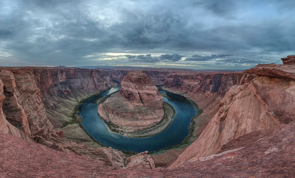 Photo: NPS / public domain
- Mar–May, Sep–Nov
- best months
Is Horseshoe Bend on the Colorado River open right now?
Closure in the area
There's a closure order in Glen Canyon National Recreation Area. It doesn't name Horseshoe Bend on the Colorado River, so check the source for the area it covers (2 listed).
Chains Road and The Chains day-use area are temporarily closed
Park closure covering Glen Canyon National Recreation Area · NPS · Glen Canyon National Recreation Area
Launch Ramp Updates
Park closure covering Glen Canyon National Recreation Area · NPS · Glen Canyon National Recreation Area
Lees Ferry Campground Partial Closure
Park alert covering Glen Canyon National Recreation Area · NPS · Glen Canyon National Recreation Area
Lake Powell Recreational Water Advisory
Park alert covering Glen Canyon National Recreation Area · NPS · Glen Canyon National Recreation Area
As of · Source: NPS · Glen Canyon National Recreation Area. Agencies don't list every closure — check before you go.
A social media darling, Horseshoe Bend has become one of the most recognized and visited places in Glen Canyon National Recreation Area. The parking lot and trailhead is located off US Highway 89, approximately 5 miles (8 km) south of the Carl Hayden Visitor Center. Changes are underway in this busy and beautiful place, including expanded parking and trail maintenance. Please respect construction closures. Much of the rim remains exposed, so watch your footing and keep track of children. Hiking The hike to the overlook is 1.5 miles (2.4 km) round-trip over a hardened path. The trail is accessible under the regulations of the Americans with Disabilities Act. There are two shade strctures along the length of the trail, but not at the overlook. There are railings at the edge of the overlook's viewing platform, but not along the trail. As with any hike, be prepared with plenty of water, sturdy footwear, sunscreen, and other basic hiking essentials. Know that there is little shade along the Horseshoe Bend Trail. Avoid hiking during the hottest part of the day. Where Am I? Horseshoe Bend has been featured as a landmark for Glen Canyon National Recreation Area, Grand Canyon National Park, the Cities of Page AZ, Kanab UT, St George UT, and the Navajo Nation. Boundary lines are very close in some places. Horseshoe Bend itself, and that part of the Colorado River, are a part of Glen Canyon National Recreation Area. About nine miles downstream is where Grand Canyon National Park begins. US Highway 89, the land north of the trail to the Horseshoe Bend overlook, and the parking area for the trailhead are in the City of Page. The land south of the parking area and the trail and overlook are on the Navajo Nation. This mixture of jurisdictions provides a unique opportunity in the management of this magnificent trail and overlook. An Entrenched Meander Below the rim, the Colorado River makes a wide sweep around a sandstone escarpment. On its long downward journey to the sea, the river meandered, sometimes making wide bends, but always seeking the path of least resistance. Around 5 million years ago, the Colorado Plateau uplifted and the meandering rivers that crossed the ancient landscape were trapped in their beds. Over time, the rivers cut through the uplifted layers of sandstone. Here at Horseshoe Bend, the Colorado River created a roughly 1,000 ft (305 m) deep, 270º horseshoe-shaped bend in Glen Canyon. Parking Fees Horseshoe Bend itself is in the park, but the parking lot is on city land. The City of Page requires visitors to pay for parking at the Horseshoe Bend trailhead. National Park Service passes do not apply for the parking lot. Contact the City of Page for questions about the parking at Horseshoe Bend at their website here. PLEASE NOTE: On Holidays and busy weekends, the City of Page may require all visitors to use a shuttle to visit once the parking lot is full. Check with them if you plan to visit during busy times.
Local outfitters
- Dixie's Lower Antelope Canyon Tours4 mi away
- Antelope Slot Canyon Tours4 mi away
Not on Roamze yet. Their page has how to reach them.
 Vermilion View TrailHikingPhoto: itia4u, CC BY 2.0 (via Flickr)0.1 mi
 Horseshoe Bend TrailHikingPhoto: itia4u, CC BY 2.0 (via Flickr)0.2 mi
- Path Through Nine-Mile DrawHikingPhoto: itia4u, CC BY 2.0 (via Flickr)0.5 mi
- Waterhole Canyon TrailHiking2.8 mi
- Waterhole Canyon TourHiking3 mi
- Colorado River ViewpointMountain biking3.6 mi
 Anchovy PointRock climbingPhoto: dougnaka, CC BY 2.0 (via Flickr)5.5 mi
 Northern ArizonaRock climbingPhoto: The Greater Southwestern Exploration Company from Claremont, California, United States, CC BY 2.0 (via Wikimedia Commons)9.9 mi
Source: Roamze catalog (indexable pages within 10 miles, PostGIS distance)
- Vermilion View TrailHiking · Next doorPhoto: itia4u, CC BY 2.0 (via Flickr)
- Horseshoe Bend TrailHiking · Next doorPhoto: itia4u, CC BY 2.0 (via Flickr)
 Spencer TrailHiking · ~7 min drivePhoto: Capt' Gorgeous, CC BY 2.0 (via Flickr)
- Spencer TrailHiking · ~7 min drivePhoto: Capt' Gorgeous, CC BY 2.0 (via Flickr)
 Wildcat Tank PathHiking · ~16 min drivePhoto: Stephen Edmonds, CC BY-SA 3.0 (via Wikimedia Commons)
- Path Through Nine-Mile DrawHiking · Next doorPhoto: itia4u, CC BY 2.0 (via Flickr)
 Historic District River TrailHiking · ~7 min drivePhoto: Capt' Gorgeous, CC BY 2.0 (via Flickr)
- Rimview TrailHiking · ~7 min drive
- Skylight Arch TrailsHiking · ~18 min drivePhoto: Stephen Edmonds, CC BY-SA 3.0 (via Wikimedia Commons)
- Upper Ferry TrailHiking · ~7 min drivePhoto: Capt' Gorgeous, CC BY 2.0 (via Flickr)
Best time to visit Horseshoe Bend on the Colorado River
Best months: March–May and September–November. Best months have typical highs of 55–85 °F, lows of 30 °F or warmer (32 °F where the station doesn't record snow), at most one snowy day and no more than 12 wet days.
Jan
45° / 26°
4 wet
Feb
51° / 30°
5 wet
Mar
62° / 38°
5 wet
Apr
71° / 44°
4 wet
May
81° / 54°
3 wet
Jun
92° / 63°
2 wet
Jul
97° / 70°
4 wet
Aug
94° / 68°
6 wet
Sep
85° / 59°
5 wet
Oct
71° / 47°
4 wet
Nov
55° / 35°
3 wet
Dec
44° / 27°
4 wet
Typical high / low (°F) and days with rain or snow, 1991–2020. Measured at Page, AZ, 4.5 mi away at 4,270 ft. This station doesn't record snowfall. Source: NOAA NCEI U.S. Climate Normals 1991–2020.

