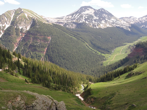
Los Pinos River
 Photo: Jeffrey Beall, CC BY 4.0 (via Wikimedia Commons)
At a glance
Los Pinos River is a 12-mile paddling stretch near Pagosa Springs, Colorado, within the Weminuche Wilderness. The San Juan National Forest's Columbine Ranger District manages the land, and the U.S. Forest Service oversees it. The river is intermittent and may run dry in some seasons. USGS models an average flow of about 84 cubic feet per second and a gradient of about 146.7 feet per mile. Summer is the most comfortable time to paddle. Typical averages from a nearby weather station show July highs around 76°F with lows near 42°F, while winter brings highs in the mid-30s and frequent snow days from December through February. Granite Lake and Divide Lakes are both within about a mile of the river. Weminuche Creek and Ute Creek, other paddling spots, lie roughly 8 miles away.
- distance
- 11.6 mi
- high point
- 10,511 ft
- best months
- Jun–Jul, Sep
Where it is: Weminuche Wilderness · Columbine Ranger District
Near: Bayfield
Best time to visit Los Pinos River
Best months: June–July and September. Best months have typical highs of 55–85 °F, lows of 30 °F or warmer (32 °F where the station doesn't record snow), at most one snowy day and no more than 12 wet days.
Jan
34°
-4°
4 wet · 4 snow
Feb
37°
-2°
4 wet · 4 snow
Mar
43°
9°
5 wet · 5 snow
Apr
50°
20°
6 wet · 5 snow
May
60°
29°
5 wet · 2 snow
Jun
71°
36°
5 wet
Jul
76°
42°
11 wet
Aug
73°
41°
13 wet
Sep
68°
35°
9 wet
Oct
58°
25°
6 wet · 2 snow
Nov
44°
12°
4 wet · 3 snow
Dec
34°
-3°
4 wet · 3 snow
Typical high / low (°F) and days with rain or snow, 1991–2020. Measured at Rio Grande Rsvr, CO, 9.3 mi away at 9,492 ft. The station sits about 1,000 ft lower than this place, so expect it a little cooler here. Source: NOAA NCEI U.S. Climate Normals 1991–2020.
Been here? Tell people how it was.
 Animas RiverCanoeingPhoto: Clyde frogg, CC BY-SA 3.0 (via Wikimedia Commons)~36 min drive
- Rio Grande Reservoir Boating SiteBoat launch~15 min drive
 West Fork San Juan RiverCanoeingPhoto: Jeffrey Beall, CC BY 4.0 (via Wikimedia Commons)~41 min drive
- Teal Boat RampBoat launch~16 min drive
 Henson CreekCanoeingPhoto: Jeffrey Beall, CC BY 4.0 (via Wikimedia Commons)~48 min drive
- Rito Hondo Reservoir Boating SiteBoat launch~38 min drive
 San Juan RiverCanoeingPhoto: Kkaufman11 at English Wikipedia, Public domain (via Wikimedia Commons)~50 min drive
- Haviland Lake Boating SiteBoat launch~44 min drive
 Hermosa CreekCanoeingPhoto: Jeffrey Beall, CC BY 4.0 (via Wikimedia Commons)~52 min drive
- Big Meadows Reservoir Boating SiteBoat launch~52 min drive
Conditions and forecast
Caution todayAgency alerts are in effect for this areaUSFS · checked 3 min agoDaily highs and lows, wind and the chance of precipitation at Start for the next 7 days, from the Open-Meteo model.
Ask about this place
Questions about Los Pinos River: conditions, access, timing. Answers say when something isn't known.
Local outfitters
- Wilderness Journeys Pagosa29 mi away
- Blue Creek Lodge33 mi away
Not on Roamze yet. Their page has how to reach them.
