Jenny Lake Campground
Campground
Campground · 0.4 mi from the trail
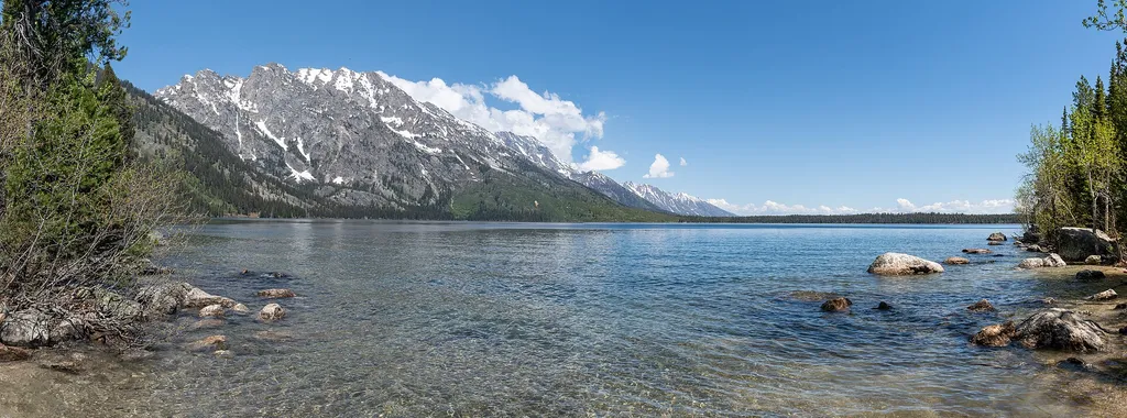 Photo: Hansueli Krapf — Wikimedia Commons (CC BY-SA 4.0)
Alert in the area
The National Park Service lists 2 alerts for Grand Teton National Park.
Construction in the South End of the Park
Park alert covering Grand Teton National Park · NPS · Grand Teton National Park
Construction on HWY 26/89/191
Park alert covering Grand Teton National Park · NPS · Grand Teton National Park
As of · Source: NPS · Grand Teton National Park. Agencies don't list every closure — check before you go.
Jenny Lake East Shore Boat Dock is a short, easy walk in Grand Teton National Park, managed by the National Park Service, about 4.5 miles from the town of Beaver Creek. The route is an out-and-back of about 1.8 miles, with a one-way climb of about 20 feet from a low point of roughly 6,791 feet to a high of about 6,899 feet. The dock is the starting point for the shuttle boat to the western side of Jenny Lake, which runs only in summer. It is also where you can buy tickets for scenic cruises and rent canoes and kayaks. Jenny Lake Boating, the park's authorized concessionaire, runs the shuttle service. Scenic cruises require a reservation. Summer is the season to plan around. Typical averages from a nearby weather station at Moose put July highs near 79°F with lows around 43°F, and August is similar. Winter is far colder, with January highs in the mid-20s. Lines are common in peak summer, so plan for that. There are no restrooms on the western side of the lake, so use the facilities before crossing. For more details, visit the Jenny Lake Boating website. Reimer's Cabin, the South Jenny Lake Walkways and the Discovery Spot: Gopher/Marten are all about 0.1 mile away. Climbers can find Falling Ant Slab about 0.4 mile off.
Jenny Lake Campground
Campground
Kelly Warm Springs
Hot spring
Places © OpenStreetMap contributors
More in JacksonNot on Roamze yet. Their page has how to reach them.
 Reimer's CabinHikingPhoto: Hansueli Krapf — Wikimedia Commons (CC BY-SA 4.0)0.1 mi
 South Jenny Lake WalkwaysHikingPhoto: inkknife_2000 (7.5 million views +), CC BY-SA 2.0 (via Wikimedia Commons)0.1 mi
 Discovery Spot: Gopher/MartenHikingPhoto: inkknife_2000 (7.5 million views +), CC BY-SA 2.0 (via Wikimedia Commons)0.1 mi
 Falling Ant SlabRock climbingPhoto: Michael Kirsh, CC BY-SA 2.0 (via Flickr)0.4 miCutfinger RockRock climbingPhoto: Michael Kirsh, CC BY-SA 2.0 (via Flickr)0.4 mi
Source: Roamze catalog (indexable pages within 10 miles, PostGIS distance)
South Jenny Lake WalkwaysHiking · Next doorPhoto: inkknife_2000 (7.5 million views +), CC BY-SA 2.0 (via Wikimedia Commons) Teton Crest TrailHiking · ~4 min drivePhoto: Bas van Oorschot, CC BY-SA 3.0 (via Wikimedia Commons)Discovery Spot: Gopher/MartenHiking · Next doorPhoto: inkknife_2000 (7.5 million views +), CC BY-SA 2.0 (via Wikimedia Commons)S Jenny Lake Parking WalkwaysHiking · Next doorPhoto: inkknife_2000 (7.5 million views +), CC BY-SA 2.0 (via Wikimedia Commons)
 Laurel Hill Climb TrailHiking · ~4 min drivePhoto: Cal Wolfe, CC BY-SA 3.0 (via Wikimedia Commons)
Also worth it near here
Cutfinger RockRock climbing · Next doorPhoto: Michael Kirsh, CC BY-SA 2.0 (via Flickr) Jenny Lake CampgroundCamping · Next doorPhoto: LikeGrantTookRichmond, CC BY-SA 3.0 (via Wikimedia Commons)
Best months: June–September. Best months have typical highs of 55–85 °F, lows of 30 °F or warmer (32 °F where the station doesn't record snow), at most one snowy day and no more than 12 wet days.
Jan
24° / 2°
17 wet
Feb
28° / 7°
16 wet
Mar
38° / 15°
15 wet
Apr
47° / 24°
14 wet
May
60° / 32°
14 wet
Jun
69° / 37°
11 wet
Jul
79° / 43°
10 wet
Aug
78° / 41°
8 wet
Sep
68° / 35°
9 wet
Oct
53° / 25°
11 wet
Nov
36° / 15°
13 wet
Dec
25° / 3°
17 wet
Typical high / low (°F) and days with rain or snow, 1991–2020. Measured at Moose 1 Nne, WY, 6.3 mi away at 6,466 ft. This station doesn't record snowfall. Source: NOAA NCEI U.S. Climate Normals 1991–2020.
