


Ruby's Inn Bryce Canyon RV Park & Campground
Hiking business nearby (~14 mi away) — hasn't claimed their Roamze page yet
Free — you'll pick up right here.
Watch this trail
Sign up to watch it — saving subscribes you to gate, closure and report changes.
Utah
822 ft
Gain
We won't guess. Here is exactly what we do and don't know.
What we do know
Inside Bryce Canyon National Park
National Park unit boundary is mapped — agency alerts for it feed this page automatically.
Boundary data
What's missing
No access route mapped
We don't yet know which road reaches this trailhead, so we can't tell you if it's gated.
Nobody's filed a report here yet — be the first.
Why you'll love it
Riggs Spring Loop Trailhead at Yovimpa
AI-suggested draft · review before you go
No permit or access details on file for this trail — check with the local land manager before you go.
<h2>Riggs Spring Loop</h2> <p><strong>Difficulty: Strenuous<br /> Total Distance: 8.8 miles (14.2 km)<br /> Ascent: 2,503 feet (763 m)<br /> Average time: 4-6 Hours<br /> <br /> <span style="color:#2980b9;">This trail may be inaccessible during mid-winter due to snow depths ranging from 2-15 ft (0.7-5 m).</span></strong><br /> Descending from the rim, this 8.8 mile (14.2 km) trail meanders through forests and raised promontories, offering stunning views of pink-hued cliffs in the distance. Gain a new perspective of the Grand Staircase by descending to its next stair--the Cretaceous sandstones of the Grey Cliffs. To preserve this experience, backcountry camping is permitted only in designated campsites. A backcountry permit must be obtained at the Visitor Center prior to any overnight trips. This trail is not as easily followed as developed trails within the Bryce Amphitheater.</p> <h4>Camping (Permits Available at Visitor Center)</h4> <p>There are 4 campsites on the 8.8 mile (14.2 km) Riggs Spring Loop Trail, which also can be accessed from here. You must obtain a permit to use these sites.</p> <h4>Under-the-Rim Trail</h4> <p>Access the Under-the-Rim Trail by following signs for the Bristlecone Loop Trail east toward Rainbow Point.</p> <h2>Backcountry Hiking and Camping</h2> <p>The Under-the-Rim Trail is approximately 22.9 miles (36.9 km) from Bryce Point to Rainbow Point. Connecting trails offer access from the park's Scenic Drive and intersect the Under-the-Rim Trail at Swamp Canyon, and Whiteman Bench. Agua Canyon Connector Trail **is closed** until further notice due to storm damage.<br /> <br /> The Riggs Spring Loop is an 8.6 mile (13.9 km) hike beginning and ending at the Rainbow and Yovimpa Point parking lot at the south end of the Scenic Drive. Either the Yovimpa or Rainbow Point trailhead may be used to access this loop.<br /> <br /> A backcountry hiking map with mileage is available at the Visitor Center. <a href="https://nps.gov/brca/planyourvisit/backcountryinfo.htm">More information</a></p> <h3>Permits Required</h3> <p>A Backcountry Permit is required for all overnight stays in the backcountry. Permits may be purchased at the Visitor Center from 9 am - 12:30 pm and 1:30 pm to 6 pm. Backcountry campsites are limited to 6 people per regular site, and 15 people per group site.</p> <h3>No Fires Permitted</h3> <p>Though gas-powered cooking stoves are allowed, no open fires are allowed anywhere in the park outside of North and Sunset Campground's established fire rings.</p> <h3>Bears and Other Wildlife</h3> <p>Bryce Canyon is home to many animals including mountain lions, coyotes and black bears. Squirrels, snakes and other small animals may also be present near your campsite.<br /> Due to the presence of black bears within Bryce Canyon National Park, the use of bear-resistant food canisters on overnight backcountry hikes is highly recommended. Bear-resistant canisters are available for loan, free of charge, at the Visitor Center.</p> <h3>Transportation</h3> <p>No park-provided transportation is provided south of Bryce Point. You can arrange a private shuttle using approved providers listed on our <a href="https://www.nps.gov/brca/planyourvisit/commercial-tours-and-services.htm">Commercial Tours and Services</a> page.</p>
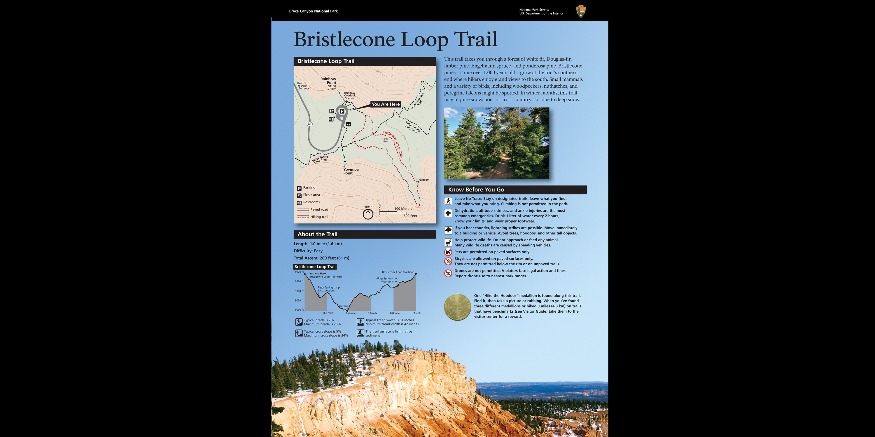
Bristlecone Loop wayside (108)
~0 min drive
This trail takes you through a forest of white fir, Douglas-fir, limber pine, and ponderosa pine. Bristlecone pines—some over 1,000 years old—grow at the trail's southern end where hikers enjoy grand views to the south. Small mammals and a variety of birds, including woodpecke…
Crawford Pass Trail
~7 min drive
Moderate 6.32-mile climb to Crawford Pass with 1,380 ft elevation gain.
Sheep Creek
~11 min drive
Easy 2.6-mile creek-side hike with 303 ft gain in northeastern Utah.
Mill Creek Trail
~11 min drive
Scenic 4.46-mile creek-side hike with 486 ft elevation gain.

Bristlecone Loop wayside (107)
~0 min drive
This trail takes you through a forest of white fir, Douglas-fir, limber pine, and ponderosa pine. Bristlecone pines—some over 1,000 years old—grow at the trail's southern end where hikers enjoy grand views to the south. Small mammals and a variety of birds, including woodpecke…
Grand View Trail
~11 min drive
Epic 150-mile Utah backcountry traverse with diverse terrain and expansive views.
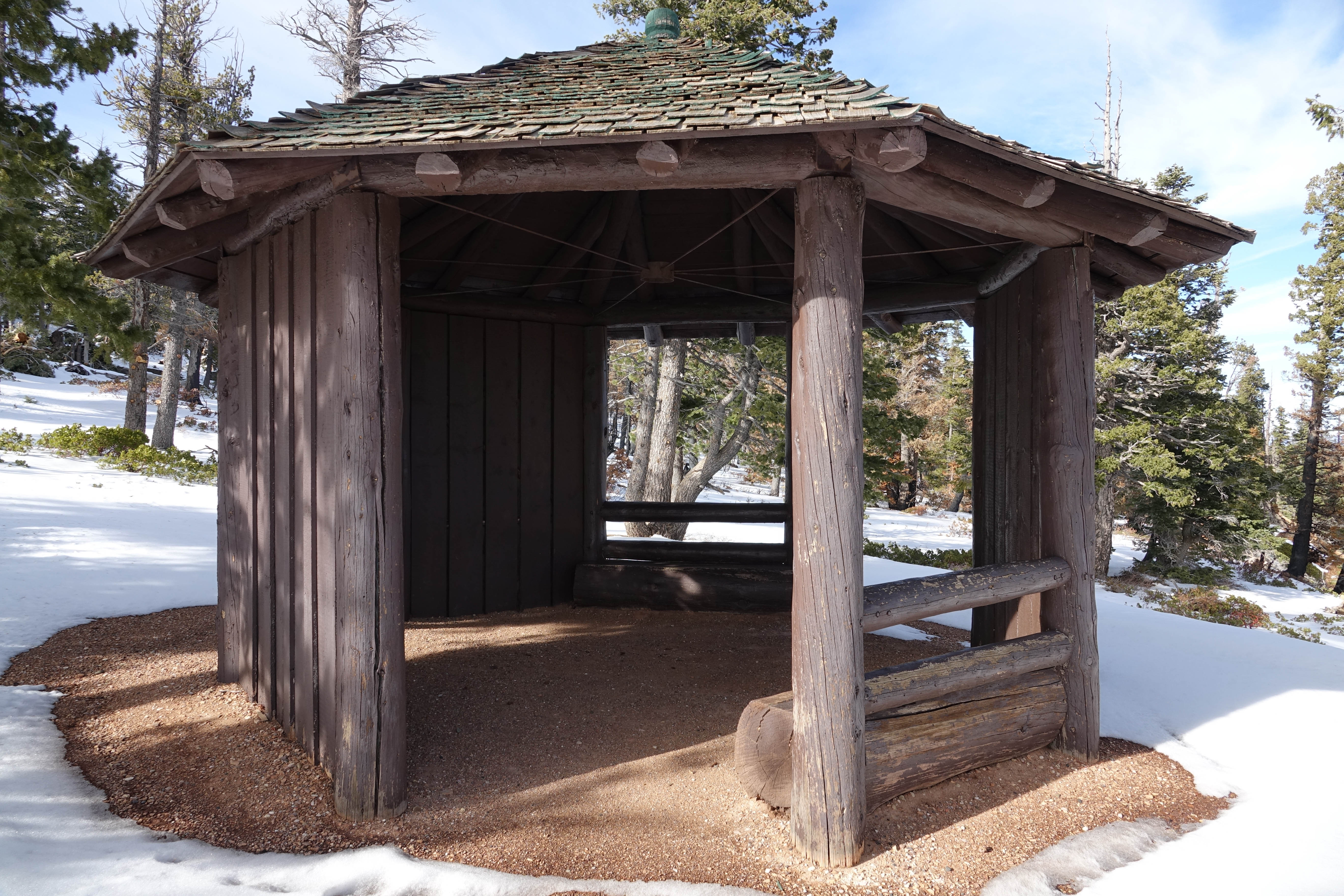
Bristlecone Loop Gazebo
~1 min drive
<p>A small octagon shaped log shelter built by the park in the 1980s after the Bristlecone Loop was completed. At this point in the trail you might recognize smaller bristlecone pines nearby. Look for densely bunched needles travelling in a bushy arrangement up the branch. Nee…
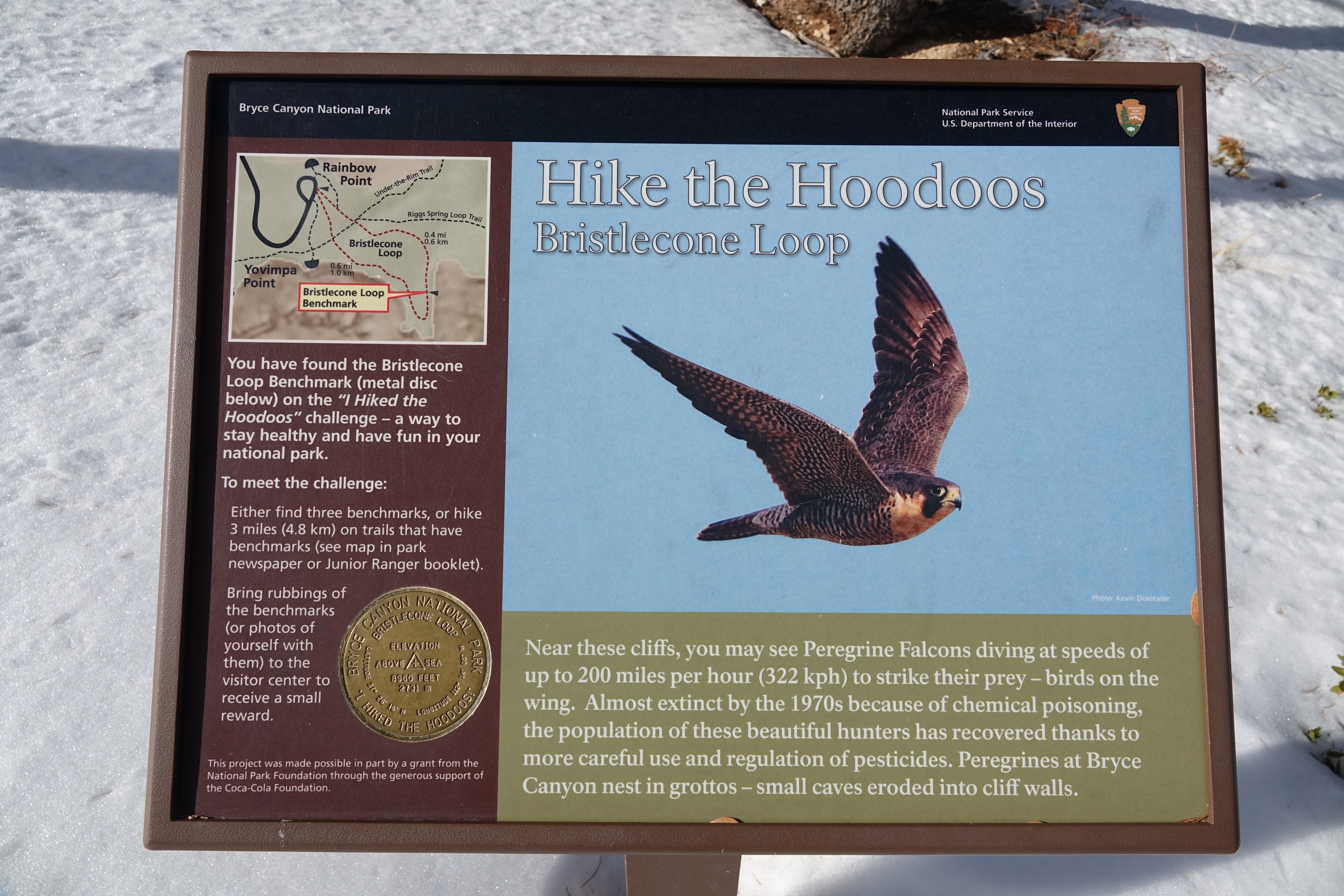
Bristlecone Loop Hike the Hoodoos
~1 min drive
<h2>I Hiked the Hoodoos</h2> <p>Hiking is great exercise and Bryce Canyon's "I Hiked the Hoodoos!" program is not just hiking, it's also a scavenger hunt with a special reward!<br /> <br /> <strong>1. Hike a minimum of 3 mi / 4.8 km, or find at least 3 benchmarks and complete…
Whiteman Trail Connections wayside
~11 min drive
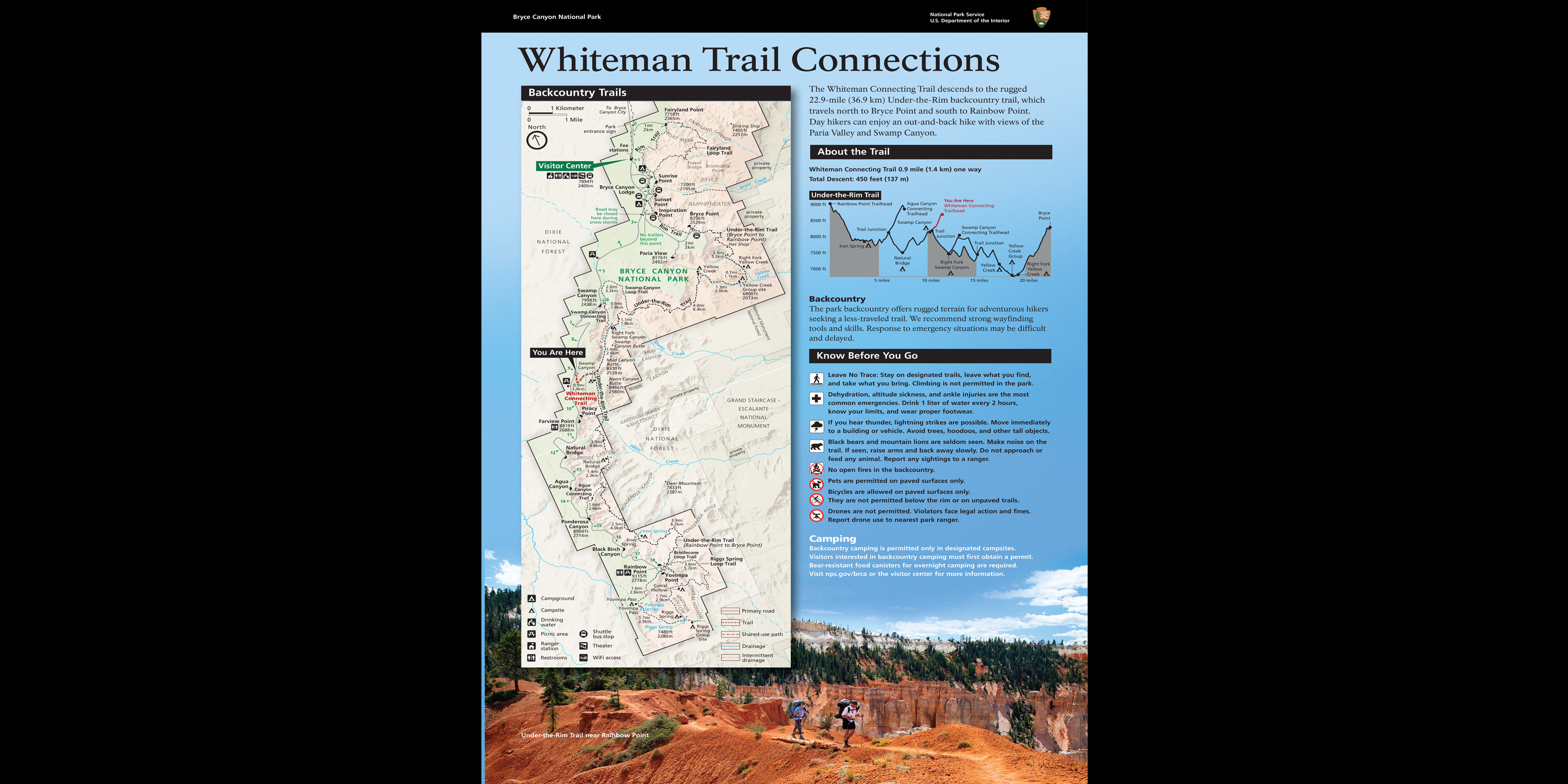
Here, the Whiteman Connecting Trail descends to the rugged 22.9-mile (36.9 km) Under-the-Rim backcountry trail, which travels north to Bryce Point and south to Rainbow Point. Day hikers can enjoy an out-and-back hike with views of the Paria Valley and Swamp Canyon.
Whiteman Connecting Trail Trailhead
~11 min drive
<h3>Whiteman Connecting Trail</h3> <p><strong>Difficulty: Moderate<br /> Total Distance: 1.0 miles (1.6 km)<br /> Ascent/Descent: 16 feet (4.9 m) / 490 feet (149 m)<br /> Average time: 1-2 hours</strong><br /> <br /> <span style="color:#2980b9;"><strong>This trail may be inacc…
Local operatorsoffering guided trips. You book directly with them — Roamze doesn’t take a cut.
Ruby's Inn Bryce Canyon RV Park & Campground
Hiking business nearby (~14 mi away) — hasn't claimed their Roamze page yet
Bryce Canyon Horseback Tours
Hiking business nearby (~15 mi away) — hasn't claimed their Roamze page yet
Red Canyon Village
Hiking business nearby (~20 mi away) — hasn't claimed their Roamze page yet