Bristlecone Loop Trailhead at Rainbow Point
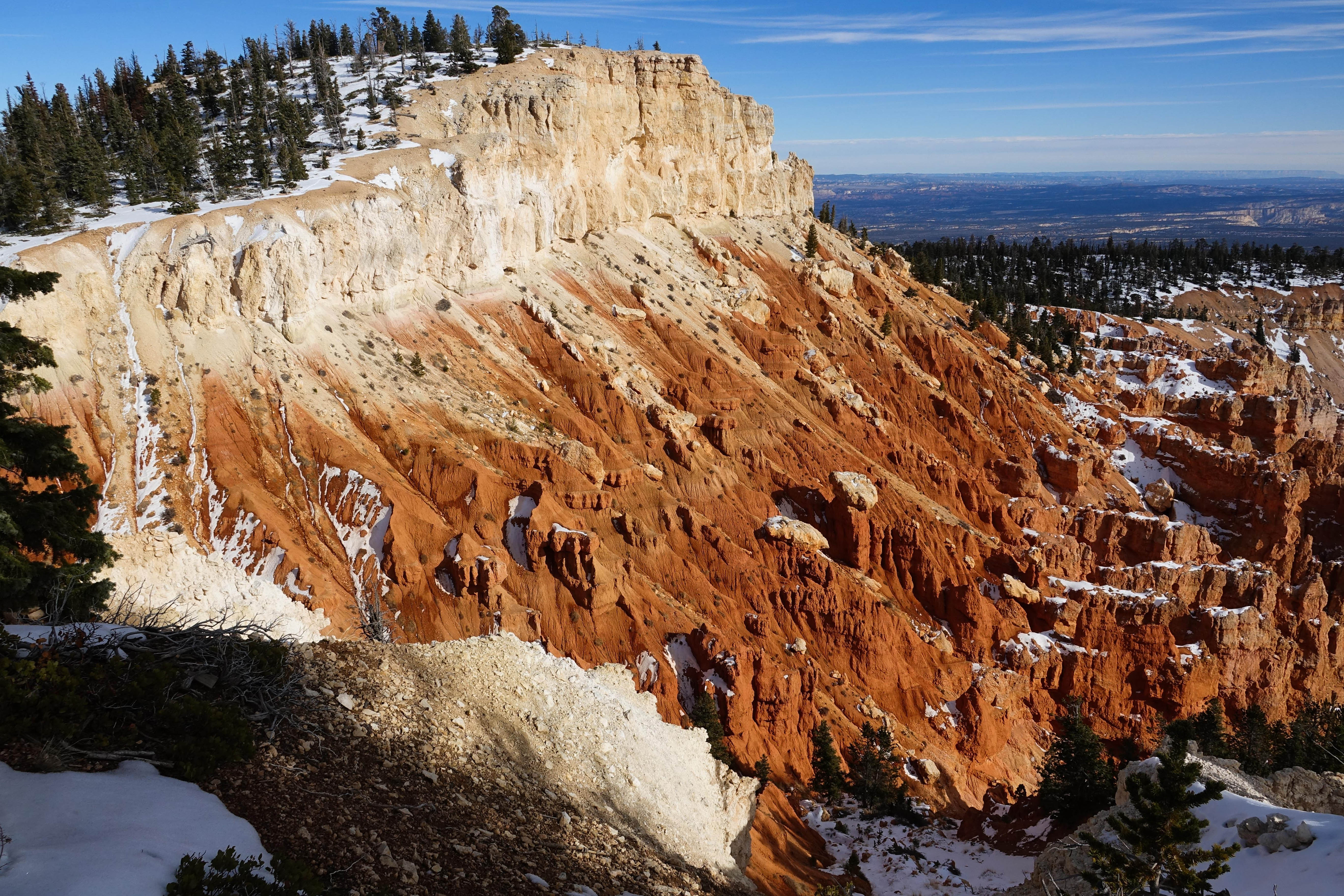 Photo: NPS Photo / Peter Densmore
- 0.8 mi
- loop
- 79 ft
- climb
- 9,093 ft
- high point
- Loop
- route
- May–Oct
- best months
Is Bristlecone Loop Trailhead at Rainbow Point open right now?
Closure in the area
There's a closure order in Bryce Canyon National Park. It doesn't name Bristlecone Loop Trailhead at Rainbow Point, so check the source for the area it covers.
Trail Closures Due to Recent Weather
Park closure covering Bryce Canyon National Park · NPS · Bryce Canyon National Park
Current Fire Restrictions
Park alert covering Bryce Canyon National Park · NPS · Bryce Canyon National Park
As of · Source: NPS · Bryce Canyon National Park. Agencies don't list every closure — check before you go.
Bristlecone Loop Trail Difficulty: Easy Total Distance: 1.0 miles (1.6 km) Elevation change: 200 feet (61 m) Average time: 1-2 hours This trail may be inaccessible during mid-winter due to snow depths ranging from 2-15 ft (0.7-5 m). The Bristlecone Loop reaches elevations over 9,100 feet (2778 m). Here you will pass by bristlecone pines up to 1,600 years old and on clear days experience vistas over 100 miles (171 km) across the Grand Staircase geologic area. The majority of the forest here is dominated by White Fir and Douglas Fir, making this good habitat for grouse, woodpeckers, owls, and a variety of squirrels and chipmunks. Many of these animals use dead and burned trees (such as those burned in the 2018 Riggs and Lonely fires) for habitat. A trail guide with map and information is available in your newspaper Visitor Guide. More about the trail Nature Bristlecone Pines Note that bristlecone pines share dolomitic limestones with some of the park's most delicate plants. Stay on the trail and help us to protect them. Though Bryce Canyon is well known for its geology, the park also contains a fantastic diversity of trees. Among the most impressive of these is the Great Basin bristlecone pine (Pinus longaeva). These trees are known for thriving where few other plants can, and for far longer too. Look for bristlecone pines on exposures of dolomitic limestone. These areas of white to grey stone are found in the park's hoodoo-forming Claron formation as low as the Queen's Garden and Fairyland Loop trails and as high as this trail. Dolomitic limestone is high in calcium and magnesium, and low in phosphorus. This chemistry is difficult for other plants to tolerate, giving the bristlecone pine plenty of room to grow as slowly as it likes. You'll also typically find higher-elevation bristlecones growing at the edges of cliffs, where competition is even further reduced. Free to take its time, bristlecones pines can grow as slowly as an inch (2.5 cm) per century if conditions are challenging. This gives these trees incredibly dense heartwood, which is capable of providing structural support to the tree long after a section of limb or trunk has lost its life-protecting bark. The oldest tree at Bryce Canyon was estimated to be 1,600 years old, though trees across its range into Nevada and California have been dated at over 5,000 years old, giving Pinus longaeva the honor of being the longest living non-clonal species on Earth. You can identify a Bristlecone pine by its densely bundled needles of five (making it a white pine). Unlike many other pines that shed their needles every few years, bristlecone pines can retain needles for up to forty years. Their 1.5 in (1.2 cm) long needles remain vibrant and green for typically a full 12 inches (30 cm) along the branch. This appearance is often compared to that of a bottlebrush or pipe cleaner. Like the limber pine (another white pine found at Bryce Canyon) seeds of the bristlecone pine may be harvested and dispersed to unlikely places by Clark's nutcrackers (Nucifraga columbiana). The seeds of their bristle-tipped cones are often among the first to colonize recently burnt areas. The Grand Staircase The Grand Staircase is an immense sequence of sedimentary rock layers that stretch south from Bryce Canyon National Park through Zion National Park and into the Grand Canyon. In the 1870s, geologist Clarence Dutton first conceptualized this region as a huge stairway ascending out of the bottom of the Grand Canyon northward with the cliff edge of each layer forming giant steps. Dutton divided this layer cake of Earth history into five steps that he colorfully named Pink Cliffs, Grey Cliffs, White Cliffs, Vermilion Cliffs, and Chocolate Cliffs. Since then, modern geologists have further divided Dutton's steps into individual rock formations. What makes the Grand Staircase worldly unique is that it preserves more Earth history than any other place on Earth. Geologists often liken the study of sedimentary rock layers to reading a history book--layer by layer, detailed chapter by detailed chapter. The problem is that in most places in the world, the book has been severely damaged by the rise and fall of mountains, the scouring of glaciers, etc. Usually these chapters are completely separated from each other and often whole pages are just missing. Yet the Grand Staircase and the lower cliffs that comprise the Grand Canyon remain largely intact speaking to over 600 million years of continuous Earth history with only a few paragraphs missing here and there. Unfortunately, the Grand Staircase is such a vast region of rock that no matter where you stand on its expanse, most of it will be hidden behind the curvature of Earth. Places such as Yovimpa Point, the Bristlecone Loop trail, and the north slope of the Kaibab Plateau are the exception where even a non-geologist can discern the individual chapters of this colossal history book--these immense steps of Dutton's Grand Staircase. Fire Natural fire is a good and necessary part of this landscape. It promotes new growth, diversity of species, removes sick and dead plant matter, and limits insect populations and the spread of plant disease. Without fire, forests become crowded, diseased, less diverse, and ultimately create conditions for large-scale destructive wildfire. In ponderosa forests within the park, fire was once common on a 3-7 year cycle, as lightning strikes would ignite low-intensity ground fires. The Ponderosa pine's thick bark protects healthy trees from the flames, while clearing the ground for new growth. At higher elevations, mixed conifer forests would burn on 11-25 year cycles, allowing first grasses, then shrubs and trees like Quaking Aspen to thrive in newly opened space. Over the last 150 years, a history of fire suppression has deprived many western forests of the benefits of fire, creating large-scale beetle attacks, loss of biodiversity, and a build-up of dead and dry plant matter ready to ignite. Here at Bryce Canyon, fire crews are working to provide these forests with the fire they need. This often begins with mechanical thinning: cutting down dead, diseased, and overcrowded trees and building burn piles that are ignited in winter. You may see these piles throughout the park. This is often a first step before broadcast ground fires can be set--if too much plant matter is present, the fire can easily grow beyond control. Burn piles reduce vegetation to a manageable level. They also help fire crews defend areas of the park when lightning starts an unexpected fire. Previous fuels reduction work in the Rainbow Point area was crucial to wildland fire crews' ability to safely manage the August 2018 Riggs and Lonely fires, which burned over 2,200 acres across National Forest, Bureau of Land Management, and National Park Service land to the southeast of Rainbow Point.
Local outfitters
- Ruby's Inn Bryce Canyon RV Park & Campground14 mi away
- Bryce Canyon Horseback Tours15 mi away
Not on Roamze yet. Their page has how to reach them.
Best time to go · May–Oct
Best time to visit Bristlecone Loop Trailhead at Rainbow Point
Best months: May–October. Best months have typical highs of 55–85 °F, lows of 30 °F or warmer (32 °F where the station doesn't record snow), at most one snowy day and no more than 12 wet days.
Jan
37° / 17°
6 wet
Feb
39° / 18°
7 wet
Mar
46° / 23°
7 wet
Apr
54° / 29°
6 wet
May
63° / 37°
5 wet
Jun
75° / 45°
4 wet
Jul
80° / 52°
8 wet
Aug
77° / 50°
10 wet
Sep
70° / 42°
7 wet
Oct
58° / 32°
5 wet
Nov
46° / 23°
5 wet
Dec
37° / 17°
6 wet
Typical high / low (°F) and days with rain or snow, 1991–2020. Measured at Bryce Canyon Np Hqrs, UT, 12.2 mi away at 7,890 ft. The station sits about 1,200 ft lower than this place, so expect it a little cooler here. This station doesn't record snowfall. Source: NOAA NCEI U.S. Climate Normals 1991–2020.
Keep exploring — more trails worth the drive
HIKE
Bristlecone Loop wayside (108)
Next door
This trail takes you through a forest of white fir, Douglas-fir, limber pine, and ponderosa pine. Bristlecone pines—some over 1,000 years old—grow at the trail's southern end where hikers enjoy grand views to the south. Small mammals and a variety of birds, including woodpecke…
HIKE
Bristlecone Loop wayside (107)
Next door
This trail takes you through a forest of white fir, Douglas-fir, limber pine, and ponderosa pine. Bristlecone pines—some over 1,000 years old—grow at the trail's southern end where hikers enjoy grand views to the south. Small mammals and a variety of birds, including woodpecke…
 Photo: Greg Willis from Denver, CO, usa, CC BY-SA 2.0 (via Wikimedia Commons)
Agua Canyon Connecting Trail
~4 min drive
1.62-mile out-and-back trail in Utah with 387 ft gain and 1,172 ft loss.
HIKE
Under-The-Rim Trail
Next door
22.06-mile out-and-back trail in Utah with 5,230 ft elevation gain.
HIKE
East Side Road
~6 min drive
7.87-mile out-and-back trail in Utah with 1,206 ft elevation gain.
HIKE
Bristlecone Loop Gazebo
Next door
A small octagon shaped log shelter built by the park in the 1980s after the Bristlecone Loop was completed. At this point in the trail you might recognize smaller bristlecone pines nearby. Look for densely bunched needles travelling in a bushy arrangement up the branch.…
HIKE
Bristlecone Loop Hike the Hoodoos
Next door
I Hiked the Hoodoos Hiking is great exercise and Bryce Canyon's "I Hiked the Hoodoos!" program is not just hiking, it's also a scavenger hunt with a special reward! 1. Hike a minimum of 3 mi / 4.8 km, or find at least 3 benchmarks and complete steps 2 through 4 below. 2.…
HIKE
Bullrush Hollow
~5 min drive
3.43-mile out-and-back trail in Utah with 63 ft of elevation gain.
HIKE
Riggs Spring Loop Trail
Next door
8.27-mile out-and-back trail in Utah with 618 ft elevation gain.
HIKE
Podunk East Road
~7 min drive
6.07-mile out-and-back trail in Utah with 1,202 ft elevation gain.

