Fossenvue Trail
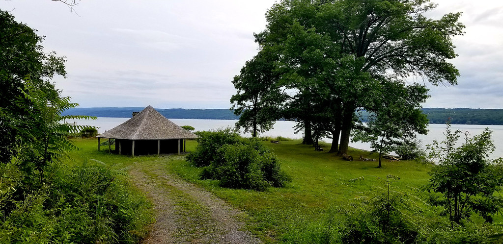 Photo: usfs_Eastern_Region, Public Domain Mark (via Flickr)
- 0.4 mi
- one way
- 243 ft
- climb
- 710 ft
- high point
- Point to point
- route
- Jul, Sep
- best months
Is Fossenvue Trail open right now?
Closure in the area
There's a closure order in Green Mountain and Finger Lakes National Forests. It doesn't name Fossenvue Trail, so check the source for the area it covers (3 listed).
Klondike Fire Incident Report
Agency closure covering Green Mountain and Finger Lakes National Forests · USFS · Green Mountain and Finger Lakes National Forests
Heavily damaged or closed trails
Agency closure covering Green Mountain and Finger Lakes National Forests · USFS · Green Mountain and Finger Lakes National Forests
Glastenbury fire tower is closed to public use
Agency closure covering Green Mountain and Finger Lakes National Forests · USFS · Green Mountain and Finger Lakes National Forests
Moosalamoo Campground Water System
Agency alert covering Green Mountain and Finger Lakes National Forests · USFS · Green Mountain and Finger Lakes National Forests
As of · Source: USFS · Green Mountain and Finger Lakes National Forests. Agencies don't list every closure — check before you go.
Fossenvue Trail is a short, easy hike in the Hector Ranger District of the Green Mountain and Finger Lakes National Forests in New York, managed by the Forest Service. The trail is about 0.4 miles long, with a one-way elevation gain of 243 feet, and it runs from a low point of about 449 feet to a high of about 710 feet. The route is a point-to-point trail, and the steepest stretch comes at about 0.23 miles in, with a grade of about 20 percent. Bikes and horses are both allowed, so the trail works for riders and equestrians as well as hikers. Summer is the most comfortable time to go. Typical averages from a nearby weather station at Penn Yan put July highs around 81°F with lows near 62°F, while September cools to highs around 73°F. Nearby options include the No-Tan-Takto Trail about 4.4 miles away, fishing on Seneca Lake about 5.2 miles away, and Backbone Horse Camp about 5.9 miles away.
Best time to go · Jul, Sep
Best time to visit Fossenvue Trail
Best months: July and September. Best months have typical highs of 55–85 °F, lows of 30 °F or warmer (32 °F where the station doesn't record snow), at most one snowy day and no more than 12 wet days.
Jan
33° / 18°
10 wet
Feb
35° / 19°
10 wet
Mar
43° / 25°
12 wet
Apr
56° / 36°
13 wet
May
69° / 47°
13 wet
Jun
77° / 57°
13 wet
Jul
81° / 62°
12 wet
Aug
80° / 60°
13 wet
Sep
73° / 53°
12 wet
Oct
61° / 43°
14 wet
Nov
48° / 33°
11 wet
Dec
38° / 25°
10 wet
Typical high / low (°F) and days with rain or snow, 1991–2020. Measured at Penn Yan Ap, NY, 11 mi away at 903 ft. This station doesn't record snowfall. Source: NOAA NCEI U.S. Climate Normals 1991–2020.
Keep exploring — more trails worth the drive
 Photo: andyarthur, CC BY 2.0 (via Flickr)
Horse
~10 min drive
0.76-mile out-and-back trail in New York with 118 ft of elevation gain.
 Photo: javajoe6, CC BY-SA 3.0 (via Wikimedia Commons)
Backbone Trail
~11 min drive
11.22-mile out-and-back trail in New York with 1,127 ft elevation gain
 Photo: javajoe6, CC BY-SA 3.0 (via Wikimedia Commons)
Burnt Hill
~12 min drive
Burnt Hill is a 4.05-mile loop in New York with 163 ft gain.
 Photo: andyarthur, CC BY 2.0 (via Flickr)
Ravine Loop
~10 min drive
0.62-mile out-and-back trail in New York with 58 ft of elevation gain.
 Photo: Seabamirum from Ithaca, CC BY 2.0 (via Wikimedia Commons)
Interloken Trail
~14 min drive
A 10.91-mile point-to-point New York trail through scenic terrain.
Photo: Seabamirum from Ithaca, CC BY 2.0 (via Wikimedia Commons)Finger Lakes / North Country Trail
~14 min drive
4.6-mile out-and-back trail in New York with 1,151 ft elevation gain
 Photo: javajoe6, CC BY-SA 3.0 (via Wikimedia Commons)
Ravine
~11 min drive
Ravine is a 1.05-mile out-and-back trail in New York with 182 feet of elevation gain.
 Photo: Carrotflower Productions International, CC BY-SA 2.0 (via Flickr)
Keuka Lake Outlet Trail Hiking
~21 min drive
6.79-mile point-to-point trail in New York with 1,348 ft gain
Photo: Seabamirum from Ithaca, CC BY 2.0 (via Wikimedia Commons)Gorge Trail
~13 min drive
Gorge Trail is a 0.79-mile point-to-point trail in New York with 4 ft gain.
 Photo: Ron Shawley, CC BY 3.0 (via Wikimedia Commons)
Indian Trail
~21 min drive
0.97-mile point-to-point trail in New York with 322 ft gain and 416 ft loss.
Map and trail data © OpenStreetMap contributors
