Saint Anthony Falls
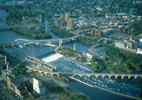 Photo: The original uploader was Mulad at English Wikipedia., Public domain (via Wikimedia Commons)
- 782 ft
- elevation
- Apr–Oct
- best months
Clear today
Weather is good · OpenWeather · checked just now
Is Saint Anthony Falls open right now?
No closures listed
The National Park Service lists no closures for Mississippi National River and Recreation Area.
As of · Source: NPS · Mississippi National River and Recreation Area. Agencies don't list every closure — check before you go.
Saint Anthony Falls is a waterfall in the Mississippi National River and Recreation Area in Minnesota, about 1.4 miles from Minneapolis. It sits at an elevation of 782 feet, and its location within the recreation area makes it an easy addition to a day spent exploring the river corridor. Summer is the most comfortable time to visit. Typical averages from a nearby weather station show July highs around 83°F with lows near 64°F, while January highs average about 22°F. The station sits at a similar elevation, so these figures are a fair guide to conditions at the falls. The Mississippi East Bank Trail, a mountain biking route, is about a mile away. The Winchell Trail is roughly 2 miles off. In winter, the Luce Line Regional Trail and the JD Rivers Trail, both cross-country ski routes, lie about 3 miles from the falls.
- Elevation
- 782 ft
Elevation from USGS 3D Elevation Program terrain data (about 10 m resolution).
- Mississippi East Bank TrailMountain biking1.1 mi
- Winchell TrailHiking2.2 mi
- Luce Line Regional TrailCross-country skiing3 mi
- JD Rivers TrailCross-country skiing3.2 mi
- Wirth Lake TrailCross-country skiing3.2 mi
- Tornado AlleyCross-country skiing3.3 mi
- Bde Maka Ska ConnectorCross-country skiing3.3 mi
- Skyline TrailCross-country skiing3.3 mi
Source: Roamze catalog (indexable pages within 10 miles, PostGIS distance)
Best time to visit Saint Anthony Falls
Best months: April–October. Best months have typical highs of 55–85 °F, lows of 30 °F or warmer (32 °F where the station doesn't record snow), at most one snowy day and no more than 12 wet days.
Jan
22° / 8°
8 wet
Feb
27° / 12°
6 wet
Mar
40° / 24°
8 wet
Apr
55° / 36°
10 wet
May
69° / 49°
12 wet
Jun
79° / 59°
12 wet
Jul
83° / 64°
10 wet
Aug
80° / 62°
8 wet
Sep
72° / 54°
9 wet
Oct
56° / 41°
9 wet
Nov
40° / 27°
7 wet
Dec
27° / 15°
8 wet
Typical high / low (°F) and days with rain or snow, 1991–2020. Measured at Lower St Anthony Falls, MN, 0.5 mi away at 754 ft. This station doesn't record snowfall. Source: NOAA NCEI U.S. Climate Normals 1991–2020.

