Observation Peak
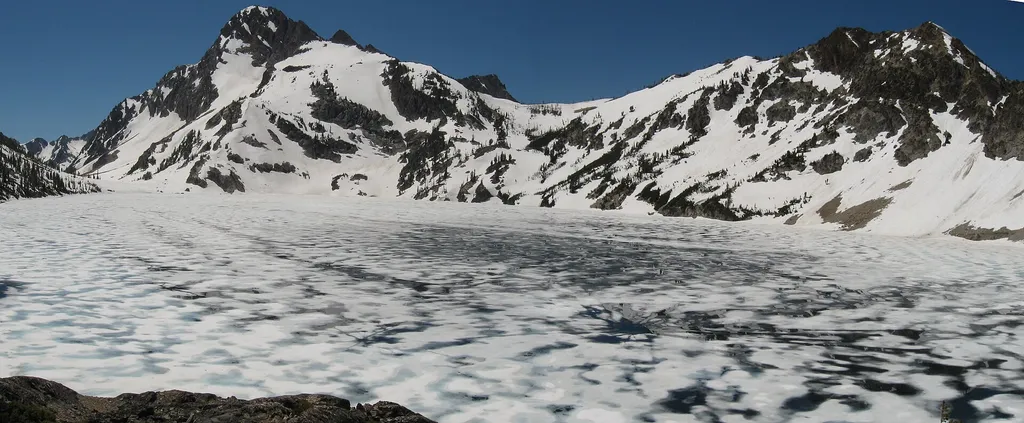 Photo: Fredlyfish4 — Wikimedia Commons (CC BY-SA 4.0)
- 2.4 mi
- round trip
- 1,013 ft
- climb
- 9,145 ft
- high point
- Out and back
- route
Is Observation Peak open right now?
Alert in the area
The Forest Service lists 4 alerts for Sawtooth National Forest.
Paradise Prescribed Burn Restricted Access
Agency alert covering Sawtooth National Forest · USFS · Sawtooth National Forest
Grandjean Area, Road, and Trail Closure
Agency alert covering Sawtooth National Forest · Order 0414-04-165 · USFS · Sawtooth National Forest
Over-Snow Vehicle and Bicycle Prohibitions
Agency alert covering Sawtooth National Forest · Order 0414-00-028 · USFS · Sawtooth National Forest
Occupancy and Use - Food Storage
Agency alert covering Sawtooth National Forest · Order 0414-04-143 · USFS · Sawtooth National Forest
As of · Source: USFS · Sawtooth National Forest. Agencies don't list every closure — check before you go.
Observation Peak is an easy out-and-back hike in Idaho's Sawtooth National Recreation Area, part of the Sawtooth National Forest managed by the Forest Service. The trail is about 2.4 miles long, with a one-way climb of about 1,000 feet from a low point of roughly 8,000 feet to a high of about 9,145 feet. The route is on natural surface, and horses are allowed. That makes it a practical choice for riders as well as hikers. For more time in the area, Trail Creek Lakes Trail lies about a mile away and North Fork Baron-Sawtooth Lake Trail about 1.7 miles off. Grandjean Campground is about 3.2 miles away, and the Salmon River offers fishing roughly 9 miles from the peak.
Local outfitters
- Camp Perkins21 mi away
- The Sawmill Station32 mi away
Not on Roamze yet. Their page has how to reach them.
Keep exploring — more trails worth the drive
 Photo: jfdervin, CC BY-SA 2.0 (via Flickr)
Goat Lake Trail
~7 min drive
2.46-mile out-and-back hike in Idaho with 830 ft elevation gain.
 Photo: Fredlyfish4 at English Wikipedia, Public domain (via Wikimedia Commons)
Alpine Way Trail
~8 min drive
35.46-mile out-and-back trail in Idaho with 1,745 ft elevation gain.
 Photo: Stephen Hanafin from Twin Falls, ID, United States, CC BY-SA 2.0 (via Wikimedia Commons)
ELK MOUNTAIN LOOKOUT
~9 min drive
6.14-mile out-and-back trail to Elk Mountain Lookout in Idaho with 1,923 ft gain
 Photo: Sam Beebe, CC BY 2.0 (via Flickr)
North Fork Boise River
~12 min drive
4.94-mile out-and-back trail on the North Fork Boise River in Idaho.
Photo: Fredlyfish4 at English Wikipedia, Public domain (via Wikimedia Commons)Iron Creek-Stanley Lake Trail
~9 min drive
1.16-mile out-and-back trail with 162 ft gain and loss, reaching 6,593 ft.
 Photo: Argyleist from Sugarhood, Utah, USA, CC BY 2.0 (via Wikimedia Commons)
ELK MOUNTAIN CUTOFF
~11 min drive
11.14-mile out-and-back trail in Idaho with 1,386 ft elevation gain.
Photo: Fredlyfish4 at English Wikipedia, Public domain (via Wikimedia Commons)ELK MOUNTAIN
~10 min drive
7.12-mile out-and-back trail in Idaho with 626 ft gain and 7,120 ft max elevation.
HIKE
Trail Creek Trail
~5 min drive
10.68-mile out-and-back trail in Idaho with 2,810 ft gain.
 Photo: bgwashburn, CC BY 2.0 (via Flickr)
Fishhook Trail
~12 min drive
1.17-mile out-and-back trail in Idaho with 63 ft of elevation gain.
 Photo: Argyleist from Sugarhood, Utah, USA, CC BY 2.0 (via Wikimedia Commons)
Redfish Creek - Baron Creek Trail
~15 min drive
42.35-mile out-and-back trail in Idaho with 1,444 ft elevation gain.

Route details
- Distance
- 2.4 mi round trip
- Climbing
- About 1,013 ft
- Summit
- 9,150 ft
- Difficulty
- Moderate
Season
Season: Year-round.
Questions about this route
How long is the Observation Peak on Observation Peak?
About 2.4 mi round trip.
How much elevation gain is on the Observation Peak?
About 1,013 ft of climbing round trip.
How hard is the Observation Peak?
It is rated moderate.
When is the best time for the Observation Peak?
Year-round.
Conditions and forecast on Observation Peak
Daily highs and lows, wind and the chance of precipitation at the summit and route start for the next 7 days, from the Open-Meteo model.
