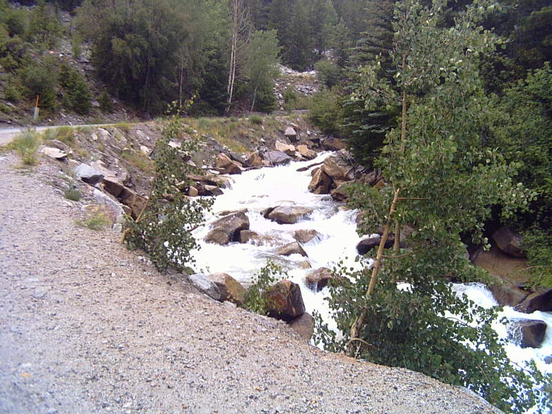
Taylor River
 Photo: Jeffrey Beall, CC BY-SA 3.0 (via Wikimedia Commons)
- 18.2 mi
- distance
- 11,255 ft
- high point
- Jun–Jul, Sep
- best months
Is Taylor River open right now?
Closure in the area
There's a closure order in Grand Mesa, Uncompahgre and Gunnison National Forests. It doesn't name Taylor River, so check the source for the area it covers (2 listed).
Gold Mountain Wildfire Roads and Trails Closure Order v 4.0
Agency closure covering Grand Mesa, Uncompahgre and Gunnison National Forests · USFS · Grand Mesa, Uncompahgre and Gunnison National Forests
Ophir Pass Road Closure
Agency closure covering Grand Mesa, Uncompahgre and Gunnison National Forests · USFS · Grand Mesa, Uncompahgre and Gunnison National Forests
Potter Basin Road Closure Order
Agency alert covering Grand Mesa, Uncompahgre and Gunnison National Forests · USFS · Grand Mesa, Uncompahgre and Gunnison National Forests
Beaver Park Road Closure Order
Agency alert covering Grand Mesa, Uncompahgre and Gunnison National Forests · USFS · Grand Mesa, Uncompahgre and Gunnison National Forests
TERMINATION OF ORDER - FIRE RESTRICTIONS
Agency alert covering Grand Mesa, Uncompahgre and Gunnison National Forests · USFS · Grand Mesa, Uncompahgre and Gunnison National Forests
As of · Source: USFS · Grand Mesa, Uncompahgre and Gunnison National Forests. Agencies don't list every closure — check before you go.
Taylor River is an 18-mile paddling stretch in Colorado, running near the town of Almont. It is a year-round waterway, with a typical average flow of about 111 cubic feet per second and a gradient of roughly 87.4 feet per mile. The land along the river is managed by the U.S. Forest Service within the Gunnison Ranger District of the Grand Mesa, Uncompahgre and Gunnison National Forests. Summer is the most comfortable season for a paddle. Typical averages from a nearby weather station show July highs around 71°F with lows near 39°F, and while that station sits about 1,300 feet lower than the river, temperatures on the water run cooler. Dorchester Campground sits just 0.7 miles away, and the Star Lily Connector Trail 623 and Bowman Creek hikes are both within about 2.5 miles. Lincoln Creek, a canoeing option, is roughly 7.6 miles from the Taylor River.
Local outfitters
- Taylor Park Marina11 mi away
- Arrowhead Point Campground and Cabins28 mi away
Not on Roamze yet. Their page has how to reach them.
- Dorchester CampgroundCamping0.7 mi
 Star Lily Connector Trail 623HikingPhoto: John Sowell, CC BY-SA 4.0 (via Wikimedia Commons)2.4 mi
- Bowman CreekHiking2.5 mi
- Lily Pond TrailHiking2.6 mi
- Campsite CC20Camping5.7 mi
- Lincoln CreekCanoeing7.6 mi
- Main ButtressRock climbing9.9 mi
- Reese's PiecesRock climbing9.9 mi
Source: Roamze catalog (indexable pages within 10 miles, PostGIS distance)
 Slate RiverCanoeing · ~31 min drivePhoto: Jeffrey Beall, CC BY 3.0 (via Wikimedia Commons)
- Taylor Reservoir MarinaBoat launch · ~20 min drive
- Lodgepole (Taylor River Canyon near Gunnison, COLORADO)Float trip · ~24 min drive
 Fryingpan RiverCanoeing · ~37 min drivePhoto: Jeffrey Beall, CC BY 4.0 (via Wikimedia Commons)
- The Slot Boating SiteBoat launch · ~24 min drive
- One MileFloat trip · ~29 min drive
 Quartz CreekCanoeing · ~49 min drivePhoto: Jeffrey Beall, CC BY 3.0 (via Wikimedia Commons)
- South Bank Access Boating SiteBoat launch · ~29 min drive
 Chalk CreekCanoeing · ~50 min drivePhoto: LanceBarber, CC BY-SA 3.0 (via Wikimedia Commons)
- Five Mile AccessBoat launch · ~33 min drive
Also worth it near here
Best time to visit Taylor River
Best months: June–July and September. Best months have typical highs of 55–85 °F, lows of 30 °F or warmer (32 °F where the station doesn't record snow), at most one snowy day and no more than 12 wet days.
Jan
30° / 5°
10 wet
Feb
31° / 6°
10 wet
Mar
37° / 12°
11 wet
Apr
43° / 19°
11 wet
May
54° / 27°
9 wet
Jun
66° / 34°
7 wet
Jul
71° / 39°
12 wet
Aug
68° / 38°
13 wet
Sep
61° / 32°
9 wet
Oct
50° / 24°
8 wet
Nov
37° / 13°
9 wet
Dec
29° / 5°
10 wet
Typical high / low (°F) and days with rain or snow, 1991–2020. Measured at Leadville Lake Co Ap, CO, 26.4 mi away at 9,932 ft. The station sits about 1,300 ft lower than this place, so expect it a little cooler here. This station doesn't record snowfall. Source: NOAA NCEI U.S. Climate Normals 1991–2020.

