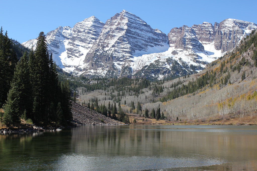
Scenic Trail (Maroon Lake)
 Photo: Michael Kirsh, CC BY-SA 2.0 (via Flickr)
- 1.4 mi
- loop
- 123 ft
- climb
- 9,716 ft
- high point
- Loop
- route
- May–Sep
- best months
Is Scenic Trail (Maroon Lake) open right now?
Alert in the area
The Forest Service lists 6 alerts for White River National Forest.
FSR 286, Radical Hill, is closed due to washouts and unsafe conditions
Agency alert covering White River National Forest · USFS · White River National Forest
Limited parking at Snowmass Creek Trailhead
Agency alert covering White River National Forest · USFS · White River National Forest
Grizzly Creek Trail Closure
Agency alert covering White River National Forest · Order 2026-02 · USFS · White River National Forest
Ruedi Marina Day Use area Dump Station is CLOSED
Agency alert covering White River National Forest · USFS · White River National Forest
Asbestos safety closure - Camp Hale
Agency alert covering White River National Forest · USFS · White River National Forest
As of · Source: USFS · White River National Forest. Agencies don't list every closure — check before you go.
The Scenic Trail (Maroon Lake) is a short, easy loop in the Maroon Bells-Snowmass Wilderness, part of the Aspen Ranger District of White River National Forest in Colorado. The Forest Service manages the land, and the trail sits within designated wilderness. The route is about 1.4 miles long, with a total elevation gain of 123 feet. It starts and ends at roughly 9,580 feet and reaches about 9,716 feet at its highest point. The trail surface is natural, and the Forest Service records show no allowance for bikes or horses. Summer is the most comfortable time to go. Typical averages from a nearby weather station in Aspen put July highs around 76°F with lows near 48°F, and the station sits well below the trail, so temperatures on the route run cooler. The Maroon-Snowmass Trail and the Maroon Lake Trail both lie about 0.4 miles away, and North Maroon Peak is about 0.6 miles off. For an overnight stay, Silver Queen Campground is about 3.5 miles away.
Go with a guide
- Mineral Belt Trail Guided WalkNexPM AI · $25 per person · 37 mi away
- Maroon Bells Guide and Outfitters6 mi away
 Maroon-Snowmass TrailSki touringPhoto: John Fowler from Placitas, NM, USA, CC BY 2.0 (via Wikimedia Commons)0.4 mi
- Maroon Lake TrailSki touringPhoto: John Fowler from Placitas, NM, USA, CC BY 2.0 (via Wikimedia Commons)0.4 mi
 North Maroon PeakHikingPhoto: Sandy Horvath-Dori from Grand Junction, CO, USA, CC BY 2.0 (via Wikimedia Commons)0.6 mi
- Maroon Lake ScenicLake fishing0.8 mi
- Silver Queen CampgroundCamping3.5 mi
- Silver Bell CampgroundCamping4.5 mi
- Castle CreekCanoeing6.8 mi
- Crested ButteRock climbing8.5 mi
Source: Roamze catalog (indexable pages within 10 miles, PostGIS distance)
- Maroon-Snowmass TrailHiking · Next doorPhoto: Michael Kirsh, CC BY-SA 2.0 (via Flickr)
- Trail near Maroon LakeHiking · Next doorPhoto: Michael Kirsh, CC BY-SA 2.0 (via Flickr)
 East Snowmass TrailHiking · ~3 min drivePhoto: Jeffrey Beall, CC BY-SA 2.0 (via Flickr)
- North Maroon PeakHiking · ~1 min drivePhoto: Sandy Horvath-Dori from Grand Junction, CO, USA, CC BY 2.0 (via Wikimedia Commons)
 West MaroonHiking · ~2 min drivePhoto: KimonBerlin, CC BY-SA 2.0 (via Wikimedia Commons)
 SummitHiking · ~10 min drivePhoto: NHV, CC BY 3.0 (via Wikimedia Commons)
 Willow LakeHiking · ~3 min drivePhoto: kalestews, CC BY 2.0 (via Flickr)
- Maroon PeakHiking · ~1 min drivePhoto: Sandy Horvath-Dori from Grand Junction, CO, USA, CC BY 2.0 (via Wikimedia Commons)
 East MaroonHiking · ~4 min drivePhoto: Cal Wolfe, CC BY-SA 3.0 (via Wikimedia Commons)
- Sierra Club LoopHiking · ~11 min drivePhoto: NHV, CC BY 3.0 (via Wikimedia Commons)
Also worth it near here
- Maroon Lake TrailSki touring · Next doorPhoto: John Fowler from Placitas, NM, USA, CC BY 2.0 (via Wikimedia Commons)
- Maroon Lake ScenicLake fishing · ~1 min drive
 Sievers MountainSummit · ~3 min drivePhoto: Robert Tadlock, CC BY 2.0 (via Wikimedia Commons)
- Conundrum Hot SpringsHot spring · ~11 min drive
Best time to visit Scenic Trail (Maroon Lake)
Best months: May–September. Best months have typical highs of 55–85 °F, lows of 30 °F or warmer (32 °F where the station doesn't record snow), at most one snowy day and no more than 12 wet days.
Jan
32° / 10°
13 wet
Feb
35° / 13°
12 wet
Mar
43° / 20°
12 wet
Apr
50° / 27°
12 wet
May
60° / 35°
11 wet
Jun
71° / 42°
8 wet
Jul
76° / 48°
11 wet
Aug
73° / 47°
12 wet
Sep
67° / 40°
10 wet
Oct
55° / 30°
9 wet
Nov
42° / 19°
10 wet
Dec
32° / 10°
12 wet
Typical high / low (°F) and days with rain or snow, 1991–2020. Measured at Aspen 1sw, CO, 8.7 mi away at 8,175 ft. The station sits about 1,500 ft lower than this place, so expect it a little cooler here. This station doesn't record snowfall. Source: NOAA NCEI U.S. Climate Normals 1991–2020.
