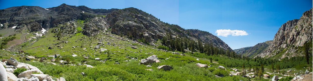
Chipmunk Flat
Chipmunk Flat in California has 11 climbing routes across 11 grades, offering bouldering, sport, and trad.
 Photo: RuggyBearLA, CC BY 2.0 (via Flickr)
- 11 routes
- 5.6 – 5.11a
- Sport · Trad · Bouldering
Is Chipmunk Flat open right now?
Closure in the area
There's a closure order in Stanislaus National Forest. It doesn't name Chipmunk Flat, so check the source for the area it covers (2 listed).
Stanislaus National Forest extends seasonal MVUM closure for two high elevation roads
Agency closure covering Stanislaus National Forest · USFS · Stanislaus National Forest
Extension of Seasonal Road Closures
Agency closure covering Stanislaus National Forest · USFS · Stanislaus National Forest
Temporary Fire Restrictions High Hazard Area Stanislaus National Forest
Agency alert covering Stanislaus National Forest · USFS · Stanislaus National Forest
Temporary Moderate Hazard Fire Restrictions Stanislaus National Forest
Agency alert covering Stanislaus National Forest · USFS · Stanislaus National Forest
As of · Source: USFS · Stanislaus National Forest. Agencies don't list every closure — check before you go.
Best time to visit Chipmunk Flat
Best months: June–September. Best months have typical highs of 55–85 °F, lows of 30 °F or warmer (32 °F where the station doesn't record snow), at most one snowy day and no more than 12 wet days.
Jan
41° / 13°
Feb
38° / 12°
Mar
42° / 15°
Apr
45° / 22°
May
54° / 27°
Jun
65° / 33°
Jul
71° / 38°
Aug
70° / 36°
Sep
65° / 32°
Oct
57° / 26°
Nov
47° / 20°
Dec
40° / 12°
Typical high / low (°F) and days with rain or snow, 1991–2020. Measured at Tuolumne Meadows Rs, CA, 35.6 mi away at 8,694 ft. This station doesn't record snowfall. Source: NOAA NCEI U.S. Climate Normals 1991–2020.
Chipmunk Flat is a climbing area in California's Stanislaus National Forest, within the Summit Ranger District, on land managed by the Forest Service. Summer is the most comfortable season to climb here. Typical averages from a nearby weather station at Tuolumne Meadows show July highs around 71°F and lows near 38°F. Winter highs at that station stay around 40°F. Blue Canyon, a hike, starts about half a mile away. Crunchy Boulder and the Stanislaus Peak hike are each roughly 1.8 miles off, and Deadman campground sits about 4 miles from the flat.
Routes (11)
Campsite Boulder(3)
Eastbound Wall(3)
First Buttress / Second Gully(1)
Keep exploring — more climbs worth the drive
 Photo: Mikeiamunion21, CC BY-SA 3.0 (via Wikimedia Commons)
Lta
~11 min drive
LTA in California offers 3 climbing routes with mixed and sport styles.
 Photo: GSEC, CC BY 2.0 (via Flickr)
Columns of the Giants
~12 min drive
Columns of the Giants in California has 2 climbing routes.
 Photo: RuggyBearLA, CC BY 2.0 (via Flickr)
Donnell Vista Parking Lot
~24 min drive
Donnell Vista Parking Lot is a California climbing crag with 7 routes.
 Photo: A Silly Person, CC BY-SA 2.0 (via Flickr)
Pinecrest Lake
~31 min drive
Pinecrest Lake is a California climbing area with 2 routes and 2 difficulty grades.
 Photo: Kurt Minard, CC BY-SA 3.0 (via Wikimedia Commons)
The Juggernaut
~33 min drive
Juggernaut, The in California has 8 climbing routes with 6 difficulty grades.
 Photo: Tom Hilton, CC BY 2.0 (via Flickr)
Incredible Hulk
~34 min drive
Incredible Hulk in California has 20 routes with 17 difficulty grades.
 Photo: Ken Lund, CC BY-SA 2.0 (via Flickr)
Walker River Canyon
~23 min drive
Walker River Canyon in California has 3 trad climbing routes with 3 difficulty grades.
Photo: Ken Lund, CC BY-SA 2.0 (via Flickr)South Buttress
~23 min drive
South Buttress in California has 5 climbing routes across 5 grades, featuring mixed and traditional styles.
Crunchy Boulder
~3 min drive
Crunchy Boulder is a bouldering area in California with 6 routes.
Big Face
~11 min drive
Big Face in California has 5 traditional climbing routes across 5 difficulty grades.