Lodgepole Campground-Sequoia and Kings Canyon National Park
Campground
The next 8 weekends are full on Recreation.gov
No closures listed
The National Park Service lists no closures for Sequoia National Park.
As of · Source: NPS · Sequoia National Park. Agencies don't list every closure — check before you go.
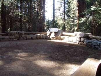
There it is! is a short exhibit in Sequoia National Park, managed by the National Park Service, about 0.1 mile from the General Sherman Tree Trail: Near the Bottom and the General Sherman Tree Trail: Halfway Point. It sits on the path leading to the base of the General Sherman Tree, the world's largest tree. The exhibit is a tactile experience. The pavement underfoot is textured, with rows of paving stones radiating in concentric circles from a central point. These stones represent a cross-section through the base of the tree, and the smooth tiles at the outer edge of the landing stand in for the bark. Walking along the edge lets you feel the "footprint" of the tree. Summer is the most comfortable time to visit. Typical averages from the nearby Lodgepole weather station show July and August highs around 76°F with lows in the mid-40s and only about two wet days a month. Winter brings highs in the upper 30s and frequent snow days. The General Sherman Tree Accessible Trail is also about 0.1 mile away. Marble Fork Overlook, a climbing area, is roughly 1.4 miles off, and Lodgepole Campground-Sequoia and Kings Canyon National Park is about 2.2 miles away.
Lodgepole Campground-Sequoia and Kings Canyon National Park
Campground
Lodgepole Market Center
Fast food
 If it rainsDavid Fulmer, CC BY 2.0 · Wikimedia Commons
Giant Forest Museum
Museum
Places © OpenStreetMap contributors · Photos: David Fulmer, CC BY 2.0 (commons)
More in Silver CityNot on Roamze yet. Their page has how to reach them.
Best months: June–October. Best months have typical highs of 55–85 °F, lows of 30 °F or warmer (32 °F where the station doesn't record snow), at most one snowy day and no more than 12 wet days.
Jan
39° / 17°
9 wet · 8 snow
Feb
41° / 18°
10 wet · 8 snow
Mar
45° / 22°
10 wet · 8 snow
Apr
50° / 26°
8 wet · 5 snow
May
58° / 33°
5 wet · 2 snow
Jun
68° / 40°
3 wet
Jul
76° / 46°
2 wet
Aug
76° / 44°
2 wet
Sep
70° / 39°
2 wet
Oct
59° / 31°
4 wet · 1 snow
Nov
47° / 23°
6 wet · 4 snow
Dec
37° / 17°
8 wet · 6 snow
Typical high / low (°F) and days with rain or snow, 1991–2020. Measured at Lodgepole, CA, 1.8 mi away at 6,735 ft. Source: NOAA NCEI U.S. Climate Normals 1991–2020.
HIKE
General Sherman Tree Trail: Near the Bottom
Next door
This wayside exhibit, titled "Near the Bottom," shows your location in relationship to the height of the General Sherman Tree.
HIKE
General Sherman Tree Trail: Halfway Point
Next door
This wayside exhibit, titled "Halfway Point," shows your location in relationship to the height of the General Sherman Tree.
 Photo: NealVickers, CC BY-SA 4.0 (via Wikimedia Commons)
Wolverton Cutoff
Next door
3.73-mile out-and-back trail in California with 772 ft gain and 7,539 ft max elevation.
HIKE
Panther Gap-Lakes
~2 min drive
1.79-mile out-and-back trail in California with 766 ft gain and 8,048 ft max elevation.
 Photo: Harald Hoyer from Schwerin, Germany, CC BY-SA 2.0 (via Wikimedia Commons)
Lodgepole-Sherman Tree
Next door
2.85-mile out-and-back trail in California reaching 7,086 ft elevation.
HIKE
There it is! (General Sherman Tree Accessible Trail)
Next door
This wayside exhibit, titled "There it is!", shows photos about the General Sherman Tree. You can also find this exhibit southwest of the General Sherman Tree, near the General Highway Parking Access.
 Photo: Henning Leweke, CC BY-SA 2.0 (via Wikimedia Commons)
Sherman Tree
Next door
0.89-mile out-and-back trail to Sherman Tree in California's national park.
HIKE
Why so big and so old? (General Sherman Tree Accessible Trail)
Next door
This wayside exhibit, titled "Why so big and so old,?" shows the sequoia's survival system. You can also find this exhibit on the west side of the General Sherman Tree.
HIKE
General Sherman Tree Accessible Trailhead
Next door
This trailhead orientation panel shows a map and images of the General Sherman Tree Accessible Trail area. You are getting close to the famous General Sherman Tree. The volume of wood in its trunk alone makes it the largest tree in the world. This trail runs from the…
HIKE
What Brings Them Down?
Next door
This wayside exhibit, titled "What Brings Them Down?," shows photos and explains why sequoia trees fall.


